Arlington Topo Map Texas
To zoom in, hover over the map of Arlington
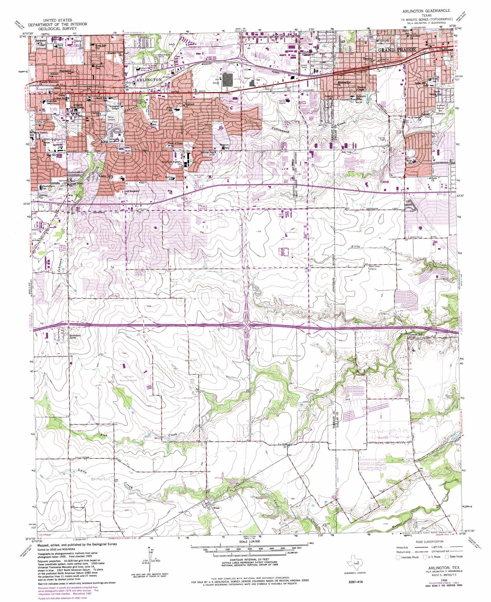
USGS Topo Quad 32097f1 - 1:24,000 scale
| Topo Map Name: | Arlington |
| USGS Topo Quad ID: | 32097f1 |
| Print Size: | ca. 21 1/4" wide x 27" high |
| Southeast Coordinates: | 32.625° N latitude / 97° W longitude |
| Map Center Coordinates: | 32.6875° N latitude / 97.0625° W longitude |
| U.S. State: | TX |
| Filename: | o32097f1.jpg |
| Download Map JPG Image: | Arlington topo map 1:24,000 scale |
| Map Type: | Topographic |
| Topo Series: | 7.5´ |
| Map Scale: | 1:24,000 |
| Source of Map Images: | United States Geological Survey (USGS) |
| Alternate Map Versions: |
Arlington TX 1959, updated 1960 Download PDF Buy paper map Arlington TX 1959, updated 1968 Download PDF Buy paper map Arlington TX 1959, updated 1969 Download PDF Buy paper map Arlington TX 1959, updated 1974 Download PDF Buy paper map Arlington TX 1959, updated 1982 Download PDF Buy paper map Arlington TX 1959, updated 1982 Download PDF Buy paper map Arlington TX 1995, updated 2002 Download PDF Buy paper map Arlington TX 2010 Download PDF Buy paper map Arlington TX 2012 Download PDF Buy paper map Arlington TX 2016 Download PDF Buy paper map |
1:24,000 Topo Quads surrounding Arlington
Keller |
Colleyville |
Grapevine |
Carrollton |
Addison |
Haltom City |
Hurst |
Euless |
Irving |
Dallas |
Fort Worth |
Kennedale |
Arlington |
Duncanville |
Oak Cliff |
Burleson |
Mansfield |
Britton |
Cedar Hill |
Lancaster |
Keene |
Alvarado |
Venus |
Midlothian |
Waxahachie |
> Back to 32097e1 at 1:100,000 scale
> Back to 32096a1 at 1:250,000 scale
> Back to U.S. Topo Maps home
Arlington topo map: Gazetteer
Arlington: Airports
Aerospatiale Helicopter Corporation Heliport elevation 163m 534′Aerospatiale Helicopter Corporation Heliport elevation 178m 583′
Arlington Memorial Hospital Heliport elevation 191m 626′
Arlington Municipal Airport elevation 188m 616′
Dallas/Fort Worth Medical Center Heliport elevation 175m 574′
Grand Prairie Municipal Airport elevation 178m 583′
Premier Aviation Incorporated Heliport elevation 180m 590′
Turbomeca Heliport elevation 178m 583′
Arlington: Crossings
Interchange 450 elevation 212m 695′Interchange 451 elevation 184m 603′
Interchange 453A elevation 177m 580′
Interchange 453B elevation 174m 570′
Interchange 454 elevation 170m 557′
Interchange 456 elevation 147m 482′
Arlington: Parks
Arlington Tennis Center - University of Texas elevation 188m 616′Bob Cook Park elevation 190m 623′
Bowie High School Stadium elevation 174m 570′
College Hill Park elevation 188m 616′
Cottonwood Park elevation 143m 469′
Cowboys Stadium elevation 175m 574′
Cravens Park elevation 183m 600′
Darena Sports Arena elevation 201m 659′
Doug Russel Park elevation 183m 600′
Freedom Park elevation 163m 534′
G Stevens Park elevation 187m 613′
Helen Wessler Park elevation 178m 583′
Holland Street Park elevation 173m 567′
Kennedy Middle School Baseball Field elevation 156m 511′
Kirby Creek Park elevation 148m 485′
Lyndon Baines Johnson Park elevation 158m 518′
Lynn Creek Park elevation 163m 534′
Meadowbrook Park elevation 174m 570′
Moore Park elevation 192m 629′
Nance James Park elevation 165m 541′
Parkhill Park elevation 162m 531′
Peppermint Park elevation 164m 538′
Pirie Park elevation 191m 626′
Senter Park elevation 183m 600′
Tyre Park elevation 167m 547′
Vandergriff Park elevation 196m 643′
Wilemon Stadium elevation 193m 633′
Winsom Park elevation 164m 538′
Workman Junior High School Field elevation 192m 629′
Arlington: Populated Places
Arlington elevation 184m 603′Florence Hill elevation 149m 488′
Southland Acres elevation 208m 682′
Webb elevation 181m 593′
Arlington: Post Offices
Bardin Road Post Office elevation 180m 590′East Arlington Post Office elevation 195m 639′
Grand Prairie Post Office elevation 158m 518′
Westchester Post Office elevation 152m 498′
Arlington: Trails
Fish Creek Linear Park Trail elevation 174m 570′Founders Park Trail elevation 196m 643′
Johnson Creek Linear Park Trail elevation 162m 531′
Arlington digital topo map on disk
Buy this Arlington topo map showing relief, roads, GPS coordinates and other geographical features, as a high-resolution digital map file on DVD: