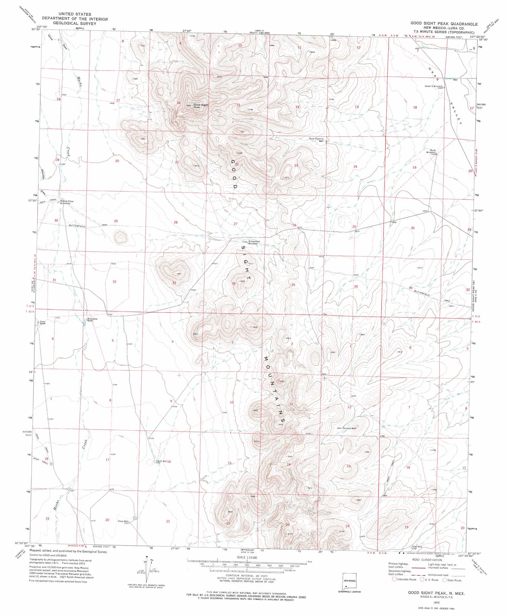
Good Sight Peak Topo Map New Mexico
To zoom in, hover over the map of Good Sight Peak
USGS Topo Quad 32107d4 - 1:24,000 scale
| Topo Map Name: | Good Sight Peak |
| USGS Topo Quad ID: | 32107d4 |
| Print Size: | ca. 21 1/4" wide x 27" high |
| Southeast Coordinates: | 32.375° N latitude / 107.375° W longitude |
| Map Center Coordinates: | 32.4375° N latitude / 107.4375° W longitude |
| U.S. State: | NM |
| Filename: | o32107d4.jpg |
| Download Map JPG Image: | Good Sight Peak topo map 1:24,000 scale |
| Map Type: | Topographic |
| Topo Series: | 7.5´ |
| Map Scale: | 1:24,000 |
| Source of Map Images: | United States Geological Survey (USGS) |
| Alternate Map Versions: |
Good Sight Peak NM 1972, updated 1975 Download PDF Buy paper map Good Sight Peak NM 2010 Download PDF Buy paper map Good Sight Peak NM 2013 Download PDF Buy paper map Good Sight Peak NM 2017 Download PDF Buy paper map |
1:24,000 Topo Quads surrounding Good Sight Peak
Whiterock Mountain |
Lake Valley |
Jug Canyon |
Arroyo Cuervo |
Hatch |
Ok Canyon |
Greg Hills |
Nutt |
Hockett |
Souse Springs |
Massacre Peak |
Florida |
Good Sight Peak |
Good Sight Peak Ne |
Magdalena Peak |
Deming East |
Carne |
Myndus |
Lazy E Ranch |
Magdalena Gap |
Capitol Dome |
Florida Gap |
Akela |
Cambray |
Mount Aden |
> Back to 32107a1 at 1:100,000 scale
> Back to 32106a1 at 1:250,000 scale
> Back to U.S. Topo Maps home
Good Sight Peak topo map: Gazetteer
Good Sight Peak: Ranges
Good Sight Mountains elevation 1540m 5052′Good Sight Peak: Springs
Williams Ranch Spring elevation 1437m 4714′Good Sight Peak: Summits
Good Sight Peak elevation 1699m 5574′Good Sight Peak: Valleys
Chandler Draw elevation 1365m 4478′China Draw elevation 1390m 4560′
Good Sight Peak: Wells
01211 Water Well elevation 1320m 4330′01272 Water Well elevation 1365m 4478′
05000 Water Well elevation 1386m 4547′
05013 Water Well elevation 1394m 4573′
05014 Water Well elevation 1329m 4360′
10017 Water Well elevation 1382m 4534′
7-E Water Well elevation 1377m 4517′
Deep Well elevation 1460m 4790′
NH 16 Water Well elevation 1372m 4501′
NH 261 Water Well elevation 1372m 4501′
Number 1208 Water Well elevation 1328m 4356′
Rush Pipeline Well elevation 1434m 4704′
Slope Well elevation 1320m 4330′
South Well elevation 1328m 4356′
Stinson Well elevation 1477m 4845′
Good Sight Peak digital topo map on disk
Buy this Good Sight Peak topo map showing relief, roads, GPS coordinates and other geographical features, as a high-resolution digital map file on DVD: