Pell City Topo Map Alabama
To zoom in, hover over the map of Pell City
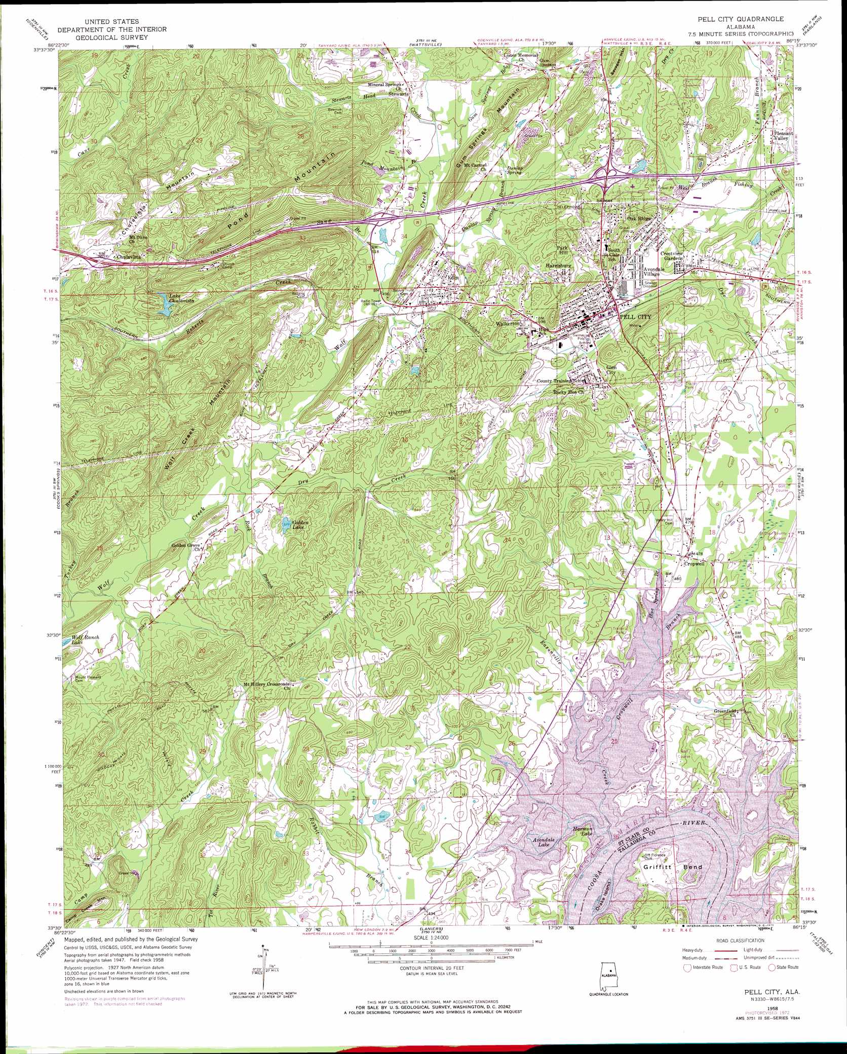
USGS Topo Quad 33086e3 - 1:24,000 scale
| Topo Map Name: | Pell City |
| USGS Topo Quad ID: | 33086e3 |
| Print Size: | ca. 21 1/4" wide x 27" high |
| Southeast Coordinates: | 33.5° N latitude / 86.25° W longitude |
| Map Center Coordinates: | 33.5625° N latitude / 86.3125° W longitude |
| U.S. State: | AL |
| Filename: | o33086e3.jpg |
| Download Map JPG Image: | Pell City topo map 1:24,000 scale |
| Map Type: | Topographic |
| Topo Series: | 7.5´ |
| Map Scale: | 1:24,000 |
| Source of Map Images: | United States Geological Survey (USGS) |
| Alternate Map Versions: |
Pell City AL 1958, updated 1960 Download PDF Buy paper map Pell City AL 1958, updated 1966 Download PDF Buy paper map Pell City AL 1958, updated 1973 Download PDF Buy paper map Pell City AL 1958, updated 1973 Download PDF Buy paper map Pell City AL 1975, updated 1977 Download PDF Buy paper map Pell City AL 2011 Download PDF Buy paper map Pell City AL 2014 Download PDF Buy paper map |
1:24,000 Topo Quads surrounding Pell City
Remlap |
Springville |
Ashville |
Cox Gap |
Ohatchee |
Argo |
Odenville |
Wattsville |
Ragland |
Francis Mill |
Leeds |
Cooks Springs |
Pell City |
Riverside |
Eastaboga |
Vandiver |
Vincent |
Laniers |
Sleeping Giants |
Talladega |
Westover |
Harpersville |
Childersburg |
Winterboro |
Porter Gap |
> Back to 33086e1 at 1:100,000 scale
> Back to 33086a1 at 1:250,000 scale
> Back to U.S. Topo Maps home
Pell City topo map: Gazetteer
Pell City: Bays
Skippers Cove elevation 142m 465′Pell City: Bends
Griffitt Bend elevation 144m 472′Pell City: Crossings
Griffiths Ferry (historical) elevation 142m 465′Interchange 153 elevation 231m 757′
Interchange 156 elevation 158m 518′
Interchange 158 elevation 185m 606′
Pell City: Dams
Chulavista Dam elevation 164m 538′Lewis Dam elevation 181m 593′
W L Golden Dam elevation 165m 541′
Pell City: Islands
Drake Island elevation 142m 465′Harmons Island elevation 144m 472′
Pell City: Lakes
Avondale Lake elevation 142m 465′Golden Lake elevation 165m 541′
Harmon Lake elevation 142m 465′
Pell City: Populated Places
Avondale Village elevation 169m 554′Carl Smith Subdivision elevation 146m 479′
Catatoga Estates elevation 148m 485′
Chulavista elevation 235m 770′
Crestview Gardens elevation 172m 564′
Cropwell elevation 146m 479′
Davis Subdivision elevation 148m 485′
Dellwood elevation 175m 574′
Eden elevation 165m 541′
Fairview Heights elevation 153m 501′
Forest Hills elevation 169m 554′
Glen City elevation 178m 583′
Griffitts Lake Shore Subdivision elevation 143m 469′
Harmon elevation 146m 479′
Harrisburg elevation 182m 597′
Hunting Ridge elevation 158m 518′
Jonny Smith Subdivision elevation 164m 538′
Lakeview elevation 169m 554′
Oak Ridge elevation 186m 610′
Park Hill elevation 194m 636′
Pell City elevation 177m 580′
Pine Orchard elevation 176m 577′
Pleasant Valley elevation 169m 554′
Riveria Estates elevation 146m 479′
Rock Inn Estates elevation 147m 482′
Stewarts elevation 165m 541′
Walkerton elevation 188m 616′
Woodmont elevation 166m 544′
Pell City: Post Offices
Pell City Post Office elevation 170m 557′Pell City: Reservoirs
Lake Chulavista elevation 168m 551′Lake Lewis elevation 181m 593′
Pell City: Ridges
Chulavista Mountain elevation 249m 816′Gum Springs Mountain elevation 227m 744′
Pell City: Springs
Dunlap Spring elevation 162m 531′Gum Springs elevation 169m 554′
Pell City: Streams
Blue Spring Branch elevation 142m 465′Cropwell Branch elevation 142m 465′
Dry Creek elevation 145m 475′
Dunlap Spring Branch elevation 152m 498′
Easonville Creek elevation 142m 465′
Fannin Branch elevation 158m 518′
Gum Springs Branch elevation 152m 498′
Pond Mountain Branch elevation 152m 498′
Roberts Creek elevation 145m 475′
Rock Branch elevation 145m 475′
Sand Branch elevation 150m 492′
Stewarts Head Creek elevation 152m 498′
Turkey Branch elevation 142m 465′
Pell City: Summits
Camp Creek Mountain elevation 215m 705′Pond Mountain elevation 275m 902′
Savages Mountain elevation 227m 744′
Wolf Creek Mountain elevation 230m 754′
Pell City digital topo map on disk
Buy this Pell City topo map showing relief, roads, GPS coordinates and other geographical features, as a high-resolution digital map file on DVD: