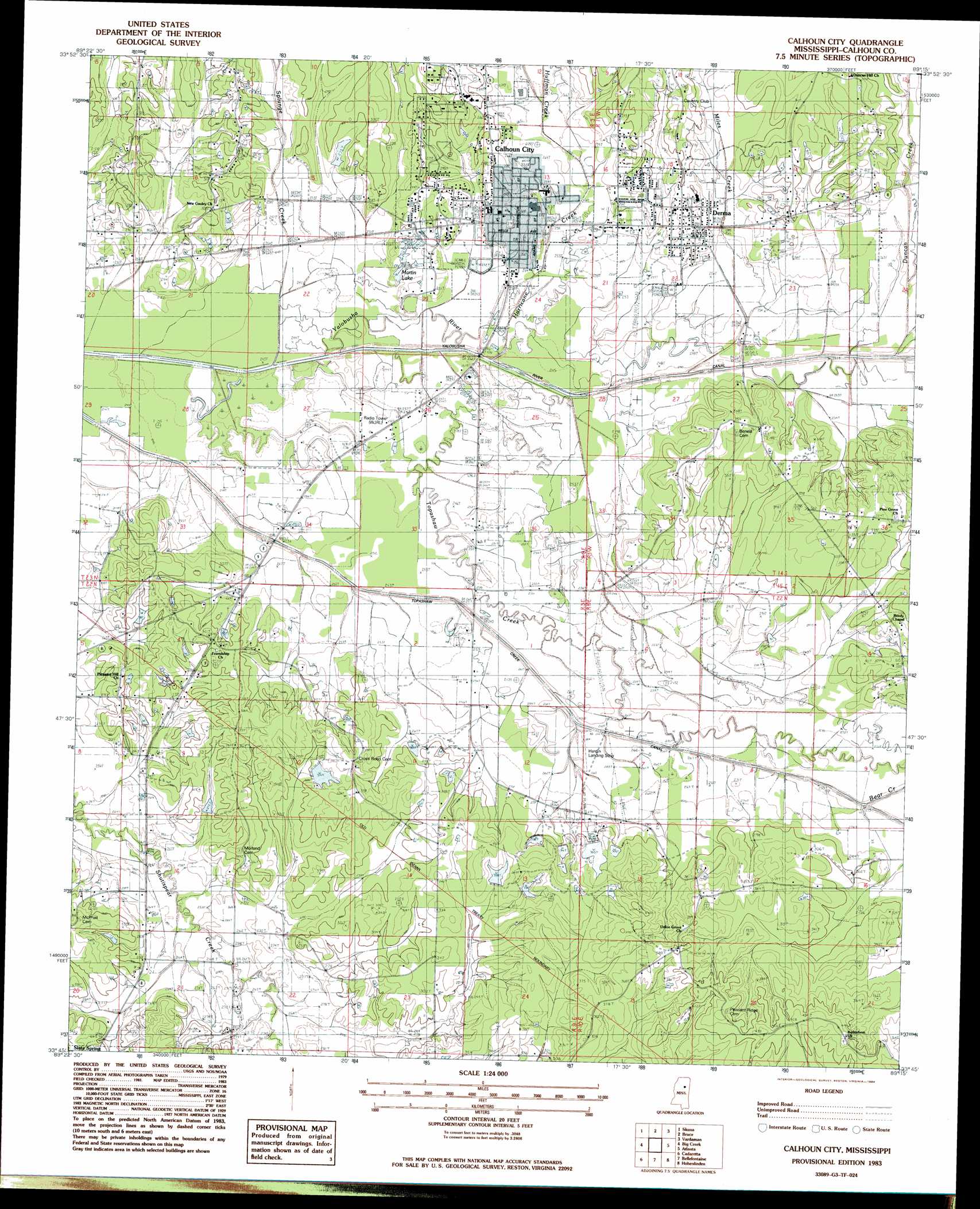
Calhoun City Topo Map Mississippi
To zoom in, hover over the map of Calhoun City
USGS Topo Quad 33089g3 - 1:24,000 scale
| Topo Map Name: | Calhoun City |
| USGS Topo Quad ID: | 33089g3 |
| Print Size: | ca. 21 1/4" wide x 27" high |
| Southeast Coordinates: | 33.75° N latitude / 89.25° W longitude |
| Map Center Coordinates: | 33.8125° N latitude / 89.3125° W longitude |
| U.S. State: | MS |
| Filename: | o33089g3.jpg |
| Download Map JPG Image: | Calhoun City topo map 1:24,000 scale |
| Map Type: | Topographic |
| Topo Series: | 7.5´ |
| Map Scale: | 1:24,000 |
| Source of Map Images: | United States Geological Survey (USGS) |
| Alternate Map Versions: |
Pittsboro SE MS 1976, updated 1977 Download PDF Buy paper map Calhoun City MS 1983, updated 1984 Download PDF Buy paper map Calhoun City MS 2012 Download PDF Buy paper map Calhoun City MS 2015 Download PDF Buy paper map |
1:24,000 Topo Quads surrounding Calhoun City
Pine Valley |
Banner |
Sarepta |
Robbs |
Houlka |
Benwood |
Skuna |
Bruce |
Vardaman |
Houston West |
Gore Springs |
Big Creek |
Calhoun City |
Atlanta |
Woodland |
Sweatman |
Cadaretta |
Bellefontaine |
Hohenlinden |
Mantee |
Lodi |
Little Sand Creek |
Eupora |
Sapa |
Maben |
> Back to 33089e1 at 1:100,000 scale
> Back to 33088a1 at 1:250,000 scale
> Back to U.S. Topo Maps home
Calhoun City topo map: Gazetteer
Calhoun City: Airports
Rainbow Field elevation 79m 259′Calhoun City: Bridges
Keas Bridge (historical) elevation 73m 239′Calhoun City: Dams
Dobbs Lake Dam elevation 88m 288′Dolan Lake Dam elevation 81m 265′
Hardin Lake Dam elevation 97m 318′
Hardin Lake Dam elevation 98m 321′
Hardin Lake Dam elevation 86m 282′
Lusious Lake Dam elevation 84m 275′
Martin Lake Dam elevation 73m 239′
Parker Pond Dam elevation 93m 305′
Calhoun City: Populated Places
Benela elevation 110m 360′Calhoun City elevation 83m 272′
Derma elevation 89m 291′
Calhoun City: Reservoirs
Martin Lakes elevation 80m 262′Calhoun City: Streams
Bear Creek elevation 78m 255′Duncan Creek elevation 77m 252′
Huffman Creek elevation 78m 255′
Hurricane Creek elevation 73m 239′
Miles Creek elevation 74m 242′
Splunge Creek elevation 73m 239′
Topashaw Creek elevation 72m 236′
Calhoun City digital topo map on disk
Buy this Calhoun City topo map showing relief, roads, GPS coordinates and other geographical features, as a high-resolution digital map file on DVD: