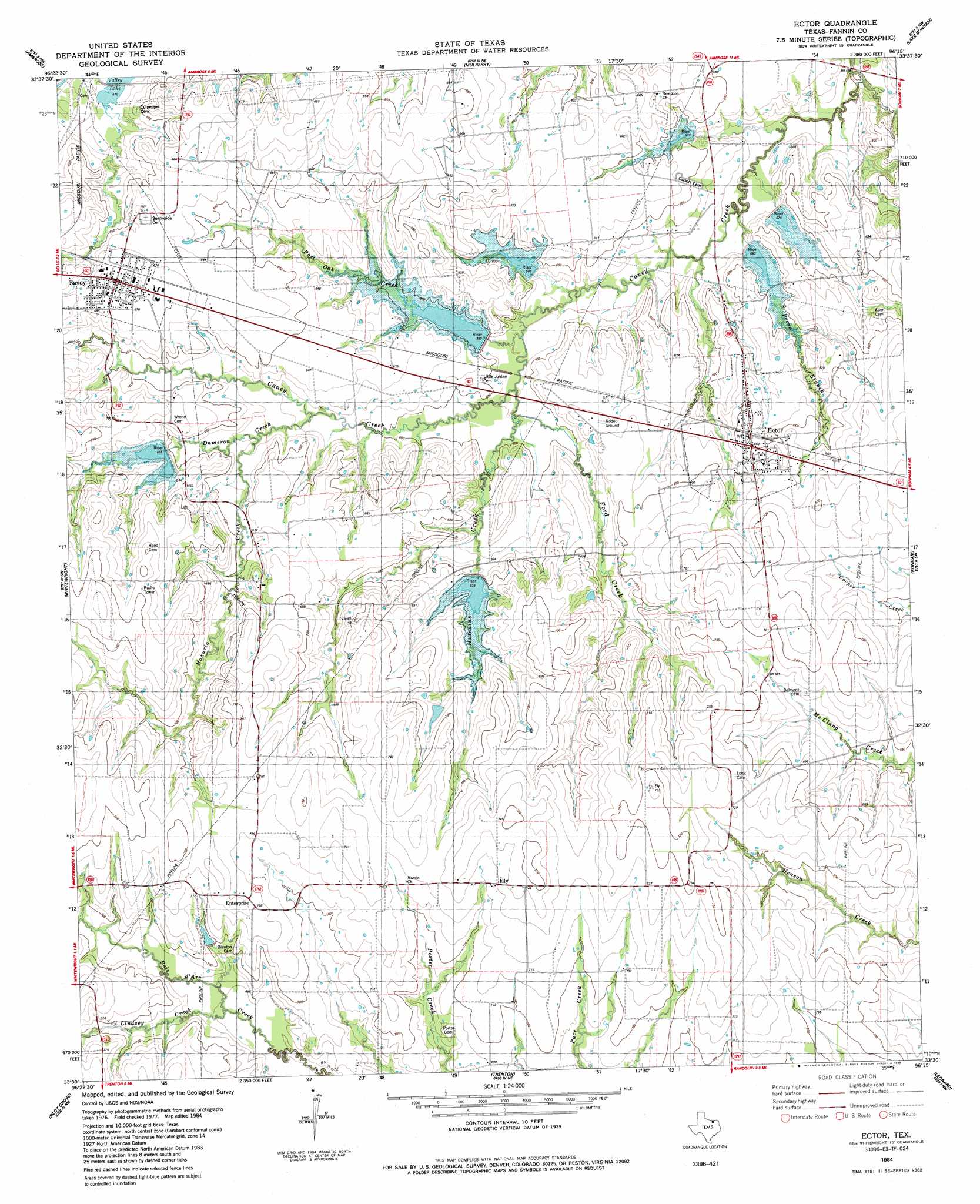
Ector Topo Map Texas
To zoom in, hover over the map of Ector
USGS Topo Quad 33096e3 - 1:24,000 scale
| Topo Map Name: | Ector |
| USGS Topo Quad ID: | 33096e3 |
| Print Size: | ca. 21 1/4" wide x 27" high |
| Southeast Coordinates: | 33.5° N latitude / 96.25° W longitude |
| Map Center Coordinates: | 33.5625° N latitude / 96.3125° W longitude |
| U.S. State: | TX |
| Filename: | o33096e3.jpg |
| Download Map JPG Image: | Ector topo map 1:24,000 scale |
| Map Type: | Topographic |
| Topo Series: | 7.5´ |
| Map Scale: | 1:24,000 |
| Source of Map Images: | United States Geological Survey (USGS) |
| Alternate Map Versions: |
Ector TX 1984, updated 1985 Download PDF Buy paper map Ector TX 2010 Download PDF Buy paper map Ector TX 2013 Download PDF Buy paper map Ector TX 2016 Download PDF Buy paper map |
1:24,000 Topo Quads surrounding Ector
Denison Dam |
Achille |
Kemp |
Yuba |
Telephone |
Sherman |
Ambrose |
Mulberry |
Lake Bonham |
Lamasco |
Howe |
Whitewright |
Ector |
Bonham |
Dodd City |
Van Alstyne |
Pilot Grove |
Trenton |
Leonard |
Gober |
Anna |
Blue Ridge |
Pike |
Celeste |
Wolfe City |
> Back to 33096e1 at 1:100,000 scale
> Back to 33096a1 at 1:250,000 scale
> Back to U.S. Topo Maps home
Ector topo map: Gazetteer
Ector: Airports
Parker Place Airport elevation 189m 620′Valley Plant Airport elevation 229m 751′
Ector: Dams
Soil Conservation Service Site 10 Dam elevation 183m 600′Soil Conservation Service Site 11 Dam elevation 171m 561′
Soil Conservation Service Site 12 Dam elevation 176m 577′
Soil Conservation Service Site 2 Dam elevation 200m 656′
Soil Conservation Service Site 5 Dam elevation 196m 643′
Soil Conservation Service Site 7 Dam elevation 183m 600′
Soil Conservation Service Site 8 Dam elevation 177m 580′
Ector: Populated Places
Ector elevation 198m 649′Ely elevation 223m 731′
Enterprise elevation 222m 728′
Savoy elevation 207m 679′
Ector: Reservoirs
Soil Conservation Service Site 10 Reservoir elevation 183m 600′Soil Conservation Service Site 11 Reservoir elevation 171m 561′
Soil Conservation Service Site 12 Reservoir elevation 176m 577′
Soil Conservation Service Site 2 Reservoir elevation 200m 656′
Soil Conservation Service Site 5 Reservoir elevation 196m 643′
Soil Conservation Service Site 7 Reservoir elevation 183m 600′
Soil Conservation Service Site 8 Reservoir elevation 177m 580′
Ector: Streams
Dameron Creek elevation 186m 610′Ford Creek elevation 181m 593′
Hutchins Creek elevation 177m 580′
Lindsey Creek elevation 201m 659′
Mahurin Creek elevation 189m 620′
Pecan Branch elevation 171m 561′
Post Oak Creek elevation 177m 580′
Ector digital topo map on disk
Buy this Ector topo map showing relief, roads, GPS coordinates and other geographical features, as a high-resolution digital map file on DVD: