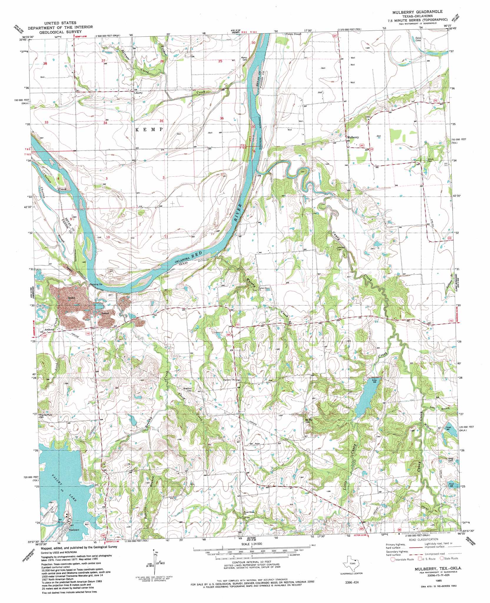
Mulberry Topo Map Texas
To zoom in, hover over the map of Mulberry
USGS Topo Quad 33096f3 - 1:24,000 scale
| Topo Map Name: | Mulberry |
| USGS Topo Quad ID: | 33096f3 |
| Print Size: | ca. 21 1/4" wide x 27" high |
| Southeast Coordinates: | 33.625° N latitude / 96.25° W longitude |
| Map Center Coordinates: | 33.6875° N latitude / 96.3125° W longitude |
| U.S. States: | TX, OK |
| Filename: | o33096f3.jpg |
| Download Map JPG Image: | Mulberry topo map 1:24,000 scale |
| Map Type: | Topographic |
| Topo Series: | 7.5´ |
| Map Scale: | 1:24,000 |
| Source of Map Images: | United States Geological Survey (USGS) |
| Alternate Map Versions: |
Mulberry TX 1985, updated 1985 Download PDF Buy paper map Mulberry TX 2010 Download PDF Buy paper map Mulberry TX 2013 Download PDF Buy paper map Mulberry TX 2016 Download PDF Buy paper map |
1:24,000 Topo Quads surrounding Mulberry
Platter |
Durant South |
Roberta |
Blue |
Bennington South |
Denison Dam |
Achille |
Kemp |
Yuba |
Telephone |
Sherman |
Ambrose |
Mulberry |
Lake Bonham |
Lamasco |
Howe |
Whitewright |
Ector |
Bonham |
Dodd City |
Van Alstyne |
Pilot Grove |
Trenton |
Leonard |
Gober |
> Back to 33096e1 at 1:100,000 scale
> Back to 33096a1 at 1:250,000 scale
> Back to U.S. Topo Maps home
Mulberry topo map: Gazetteer
Mulberry: Dams
Carpenter Lake Dam elevation 161m 528′Klose Lake Dam elevation 173m 567′
Soil Conservation Service Site 13 Dam elevation 168m 551′
Soil Conservation Service Site 14 Dam elevation 170m 557′
Soil Conservation Service Site 15 Dam elevation 164m 538′
Texas No Name Number 31 Dam elevation 178m 583′
Valley Lake Dam elevation 171m 561′
Mulberry: Guts
Caney Slough elevation 149m 488′Choctaw Slough elevation 152m 498′
Mulberry: Lakes
Spies Lake elevation 149m 488′Mulberry: Populated Places
Anthony elevation 163m 534′Liberty elevation 170m 557′
Mulberry elevation 167m 547′
Mulberry: Reservoirs
Carpenter Lake elevation 161m 528′Klose Lake elevation 173m 567′
Soil Conservation Service Site 13 Reservoir elevation 168m 551′
Soil Conservation Service Site 14 Reservoir elevation 170m 557′
Soil Conservation Service Site 15 Reservoir elevation 164m 538′
Valley Lake elevation 171m 561′
Mulberry: Streams
Brushy Creek elevation 148m 485′Caney Creek elevation 149m 488′
Caney Creek elevation 147m 482′
Choctaw Creek elevation 147m 482′
Choctaw Creek elevation 147m 482′
Lees Branch elevation 159m 521′
Little Caney Creek elevation 154m 505′
Murphy Creek elevation 149m 488′
Pattillo Branch elevation 168m 551′
Pepper Creek elevation 145m 475′
Sand Creek elevation 148m 485′
Sheep Creek elevation 162m 531′
Skinner Creek elevation 159m 521′
Wilhoit Branch elevation 159m 521′
Mulberry digital topo map on disk
Buy this Mulberry topo map showing relief, roads, GPS coordinates and other geographical features, as a high-resolution digital map file on DVD: