Kemp Topo Map Oklahoma
To zoom in, hover over the map of Kemp
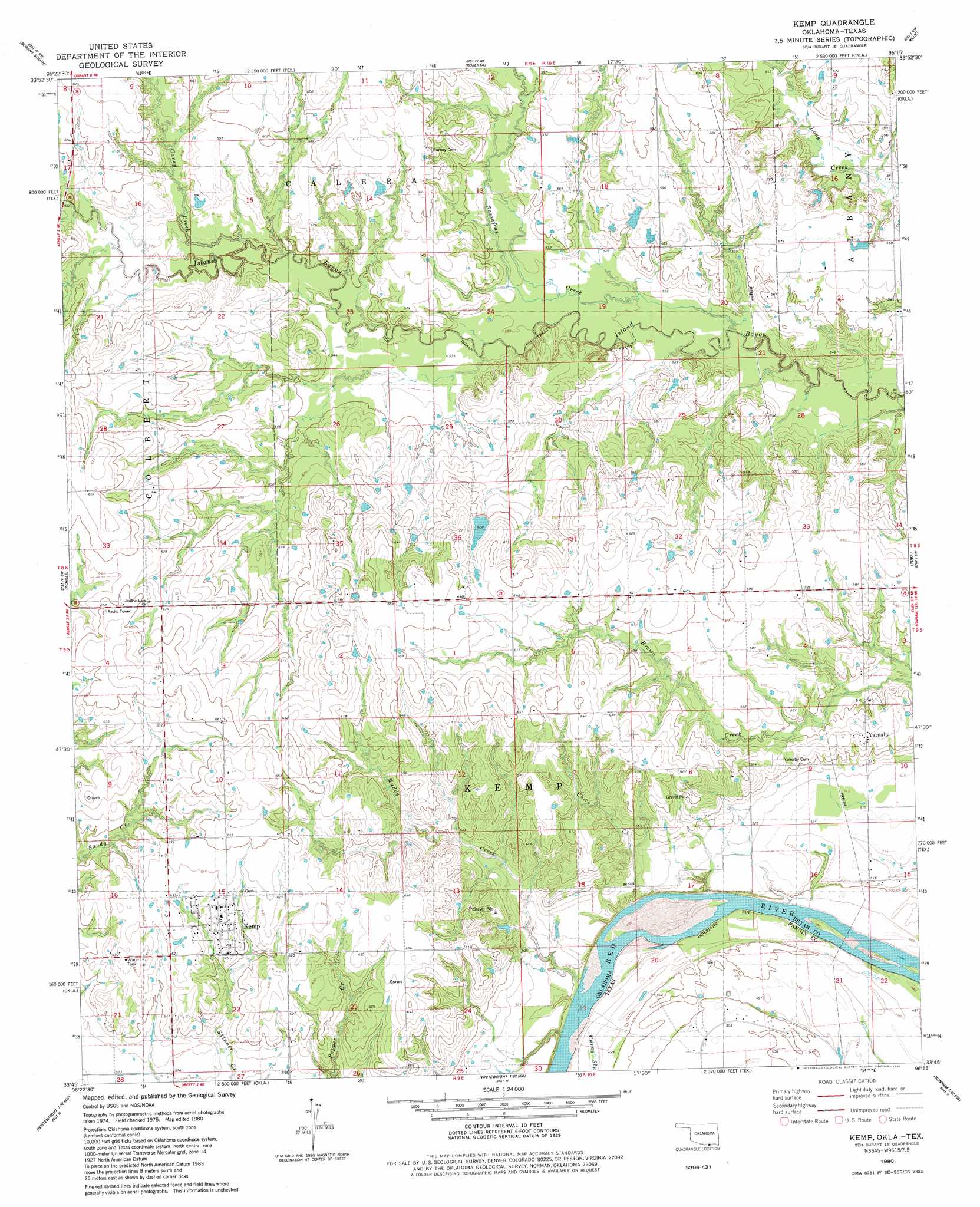
USGS Topo Quad 33096g3 - 1:24,000 scale
| Topo Map Name: | Kemp |
| USGS Topo Quad ID: | 33096g3 |
| Print Size: | ca. 21 1/4" wide x 27" high |
| Southeast Coordinates: | 33.75° N latitude / 96.25° W longitude |
| Map Center Coordinates: | 33.8125° N latitude / 96.3125° W longitude |
| U.S. States: | OK, TX |
| Filename: | o33096g3.jpg |
| Download Map JPG Image: | Kemp topo map 1:24,000 scale |
| Map Type: | Topographic |
| Topo Series: | 7.5´ |
| Map Scale: | 1:24,000 |
| Source of Map Images: | United States Geological Survey (USGS) |
| Alternate Map Versions: |
Kemp OK 1980, updated 1981 Download PDF Buy paper map Kemp OK 2010 Download PDF Buy paper map Kemp OK 2013 Download PDF Buy paper map Kemp OK 2016 Download PDF Buy paper map |
1:24,000 Topo Quads surrounding Kemp
Little City |
Durant North |
Caddo South |
Bokchito |
Bennington North |
Platter |
Durant South |
Roberta |
Blue |
Bennington South |
Denison Dam |
Achille |
Kemp |
Yuba |
Telephone |
Sherman |
Ambrose |
Mulberry |
Lake Bonham |
Lamasco |
Howe |
Whitewright |
Ector |
Bonham |
Dodd City |
> Back to 33096e1 at 1:100,000 scale
> Back to 33096a1 at 1:250,000 scale
> Back to U.S. Topo Maps home
Kemp topo map: Gazetteer
Kemp: Dams
Garner Lake Dam elevation 173m 567′Oknoname 013013 Dam elevation 186m 610′
Oknoname 013014 Dam elevation 191m 626′
Robinson Lake Dam elevation 171m 561′
Rodgers Lake Number 3 Dam elevation 169m 554′
Kemp: Populated Places
Kemp elevation 193m 633′Yarnaby elevation 175m 574′
Kemp: Reservoirs
Garner Lake elevation 173m 567′Oknoname 013013 Reservoir elevation 186m 610′
Oknoname 013014 Reservoir elevation 191m 626′
Robinson Lake elevation 171m 561′
Rodgers Lake Number 3 elevation 169m 554′
Kemp: Streams
Caney Creek elevation 165m 541′Chico Creek elevation 145m 475′
Muddy Creek elevation 146m 479′
Sassafras Creek elevation 154m 505′
Kemp digital topo map on disk
Buy this Kemp topo map showing relief, roads, GPS coordinates and other geographical features, as a high-resolution digital map file on DVD: