Lake Bonham Topo Map Texas
To zoom in, hover over the map of Lake Bonham
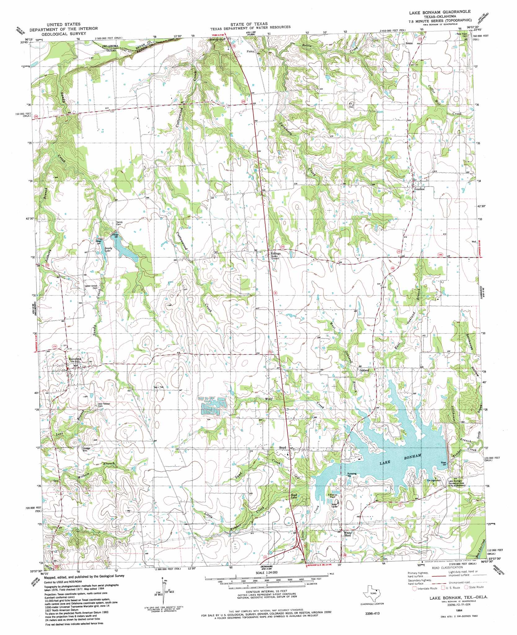
USGS Topo Quad 33096f2 - 1:24,000 scale
| Topo Map Name: | Lake Bonham |
| USGS Topo Quad ID: | 33096f2 |
| Print Size: | ca. 21 1/4" wide x 27" high |
| Southeast Coordinates: | 33.625° N latitude / 96.125° W longitude |
| Map Center Coordinates: | 33.6875° N latitude / 96.1875° W longitude |
| U.S. States: | TX, OK |
| Filename: | o33096f2.jpg |
| Download Map JPG Image: | Lake Bonham topo map 1:24,000 scale |
| Map Type: | Topographic |
| Topo Series: | 7.5´ |
| Map Scale: | 1:24,000 |
| Source of Map Images: | United States Geological Survey (USGS) |
| Alternate Map Versions: |
Lake Bonham TX 1984, updated 1985 Download PDF Buy paper map Lake Bonham TX 2010 Download PDF Buy paper map Lake Bonham TX 2013 Download PDF Buy paper map Lake Bonham TX 2016 Download PDF Buy paper map |
| FStopo: | US Forest Service topo Lake Bonham is available: Download FStopo PDF Download FStopo TIF |
1:24,000 Topo Quads surrounding Lake Bonham
Durant South |
Roberta |
Blue |
Bennington South |
Lake West |
Achille |
Kemp |
Yuba |
Telephone |
Monkstown |
Ambrose |
Mulberry |
Lake Bonham |
Lamasco |
Selfs |
Whitewright |
Ector |
Bonham |
Dodd City |
Honey Grove |
Pilot Grove |
Trenton |
Leonard |
Gober |
Ladonia |
> Back to 33096e1 at 1:100,000 scale
> Back to 33096a1 at 1:250,000 scale
> Back to U.S. Topo Maps home
Lake Bonham topo map: Gazetteer
Lake Bonham: Dams
Corrigan Lake Number 1 Dam elevation 167m 547′Corrigan Lake Number 2 Dam elevation 161m 528′
Lake Bonham Dam elevation 162m 531′
Lake Bonham: Lakes
Boyd Lake elevation 176m 577′Lake Bonham: Parks
Lake Bonham Park elevation 176m 577′Lake Bonham: Populated Places
Bettis elevation 184m 603′Boyd elevation 184m 603′
Finley elevation 161m 528′
Ivanhoe elevation 186m 610′
Oakland elevation 181m 593′
Ravenna elevation 182m 597′
Ridings elevation 180m 590′
White Shed elevation 182m 597′
Lake Bonham: Reservoirs
Corrigan Lake Number 1 elevation 167m 547′Corrigan Lake Number 2 elevation 161m 528′
Lake Bonham elevation 172m 564′
Sandy Lake elevation 166m 544′
Lake Bonham: Streams
Anthony Branch elevation 155m 508′Bettis Creek elevation 150m 492′
East Oakland Branch elevation 161m 528′
Little Timber Creek elevation 172m 564′
Sand Creek elevation 173m 567′
Stillhouse Branch elevation 162m 531′
West Oakland Branch elevation 172m 564′
Wolf Creek elevation 172m 564′
Lake Bonham: Valleys
Stillhouse Hollow elevation 167m 547′Lake Bonham digital topo map on disk
Buy this Lake Bonham topo map showing relief, roads, GPS coordinates and other geographical features, as a high-resolution digital map file on DVD: