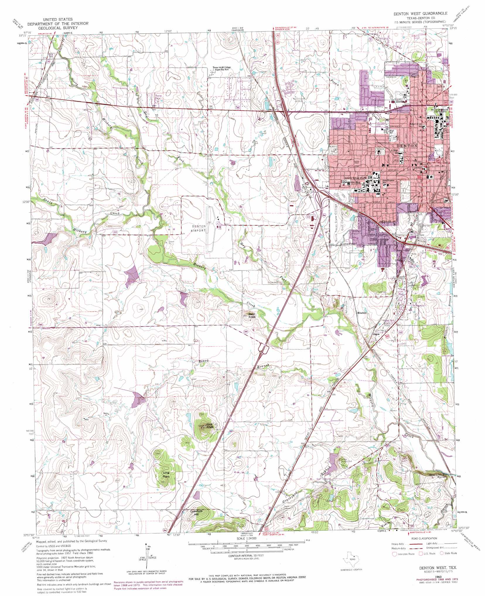
Denton West Topo Map Texas
To zoom in, hover over the map of Denton West
USGS Topo Quad 33097b2 - 1:24,000 scale
| Topo Map Name: | Denton West |
| USGS Topo Quad ID: | 33097b2 |
| Print Size: | ca. 21 1/4" wide x 27" high |
| Southeast Coordinates: | 33.125° N latitude / 97.125° W longitude |
| Map Center Coordinates: | 33.1875° N latitude / 97.1875° W longitude |
| U.S. State: | TX |
| Filename: | o33097b2.jpg |
| Download Map JPG Image: | Denton West topo map 1:24,000 scale |
| Map Type: | Topographic |
| Topo Series: | 7.5´ |
| Map Scale: | 1:24,000 |
| Source of Map Images: | United States Geological Survey (USGS) |
| Alternate Map Versions: |
Denton West TX 1960, updated 1962 Download PDF Buy paper map Denton West TX 1960, updated 1969 Download PDF Buy paper map Denton West TX 1960, updated 1974 Download PDF Buy paper map Denton West TX 1960, updated 1974 Download PDF Buy paper map Denton West TX 2010 Download PDF Buy paper map Denton West TX 2013 Download PDF Buy paper map Denton West TX 2016 Download PDF Buy paper map |
1:24,000 Topo Quads surrounding Denton West
Greenwood |
Era |
Valley View |
Mountain Springs |
Pilot Point |
Slidell |
Era Se |
Sanger |
Green Valley |
Aubrey |
Bluett |
Ponder |
Denton West |
Denton East |
Little Elm |
Rhome |
Justin |
Argyle |
Lewisville West |
Lewisville East |
Avondale |
Keller |
Colleyville |
Grapevine |
Carrollton |
> Back to 33097a1 at 1:100,000 scale
> Back to 33096a1 at 1:250,000 scale
> Back to U.S. Topo Maps home
Denton West topo map: Gazetteer
Denton West: Airports
Addington Field elevation 212m 695′Denton Municipal Airport elevation 196m 643′
Denton Regional Medical Center-Flow Campus Heliport elevation 216m 708′
Myska Field elevation 180m 590′
Denton West: Dams
Country Club Lake Dam elevation 180m 590′Rayzor Lake Dam elevation 199m 652′
Soil Conservation Service Site 11 Dam elevation 208m 682′
Soil Conservation Service Site 12 Dam elevation 189m 620′
Soil Conservation Service Site 13 Dam elevation 190m 623′
Soil Conservation Service Site 14 Dam elevation 195m 639′
Soil Conservation Service Site 16 Dam elevation 204m 669′
Soil Conservation Service Site 17a Dam elevation 207m 679′
Denton West: Parks
Denia Park elevation 203m 666′Denton Independent School District Stadium elevation 195m 639′
Dwight Gailey Stadium elevation 198m 649′
Evers Park elevation 204m 669′
Fouts Field elevation 205m 672′
Fouts Field elevation 206m 675′
McKenna Park elevation 228m 748′
McKenna Park elevation 222m 728′
North Lakes Park elevation 210m 688′
University of North Texas Coliseum elevation 212m 695′
Denton West: Populated Places
Denton elevation 201m 659′Jagoe elevation 179m 587′
Minchin elevation 190m 623′
Denton West: Reservoirs
Country Club Lake elevation 180m 590′Rayzor Lake elevation 199m 652′
Soil Conservation Service Site 13 Reservoir elevation 190m 623′
Soil Conservation Service Site 14 Reservoir elevation 195m 639′
Soil Conservation Service Site 16 Reservoir elevation 204m 669′
Soil Conservation Service Site 17a Reservoir elevation 207m 679′
Soil Conservation Service Site Number 11 Reservoir elevation 208m 682′
Soil Conservation Service Site Number 12 Reservoir elevation 189m 620′
Denton West: Streams
Dry Fork Hickory Creek elevation 171m 561′Graveyard Branch elevation 165m 541′
North Hickory Creek elevation 182m 597′
Roark Branch elevation 168m 551′
South Hickory Creek elevation 182m 597′
Denton West: Summits
Bald Knob elevation 207m 679′Crawford Hill elevation 231m 757′
Long Point elevation 234m 767′
Pilot Knob elevation 253m 830′
Denton West: Trails
North Lakes Park Trail elevation 209m 685′South Lakes Park Trail elevation 188m 616′
Denton West digital topo map on disk
Buy this Denton West topo map showing relief, roads, GPS coordinates and other geographical features, as a high-resolution digital map file on DVD: