Escudilla Mountain Topo Map Arizona
To zoom in, hover over the map of Escudilla Mountain
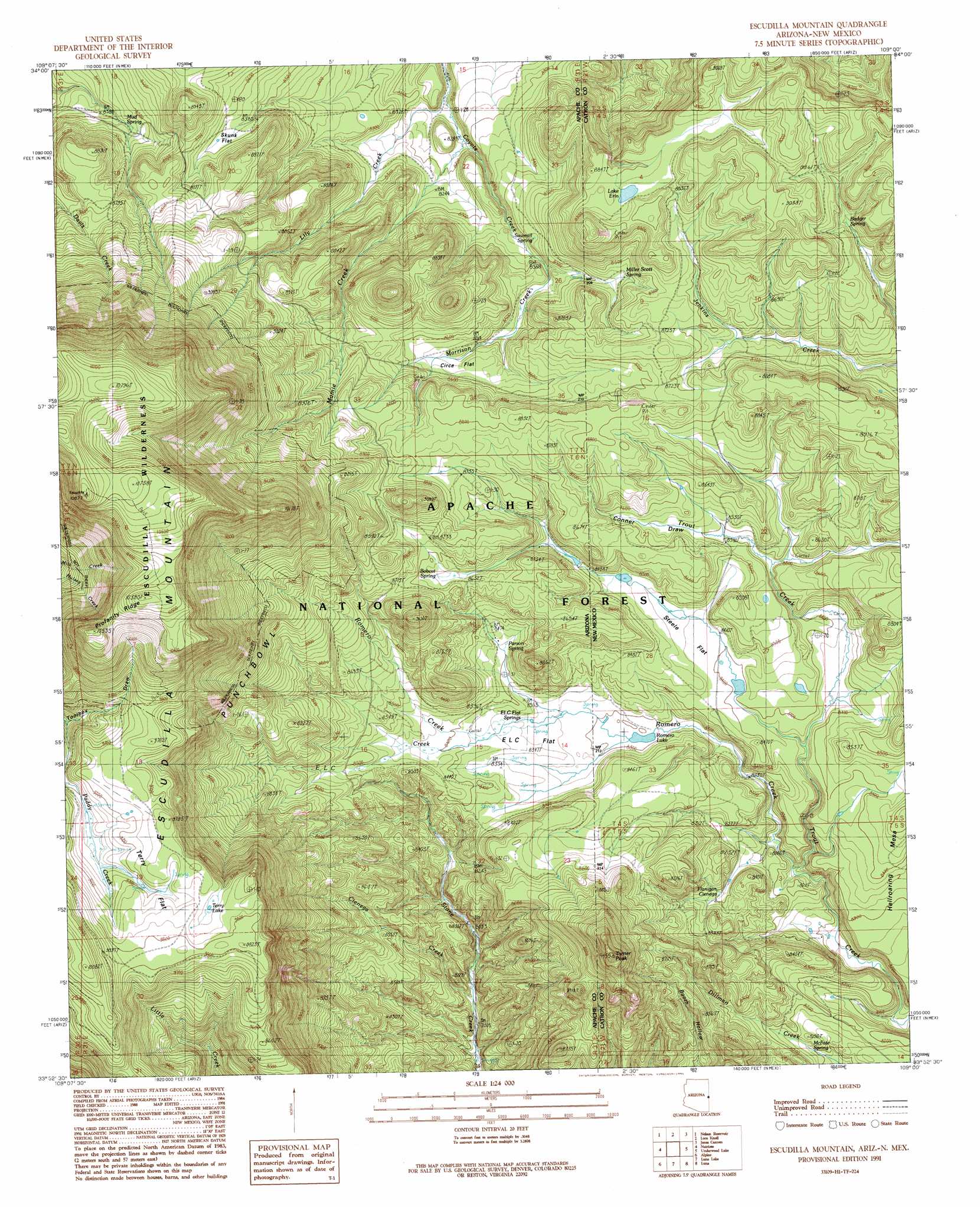
USGS Topo Quad 33109h1 - 1:24,000 scale
| Topo Map Name: | Escudilla Mountain |
| USGS Topo Quad ID: | 33109h1 |
| Print Size: | ca. 21 1/4" wide x 27" high |
| Southeast Coordinates: | 33.875° N latitude / 109° W longitude |
| Map Center Coordinates: | 33.9375° N latitude / 109.0625° W longitude |
| U.S. States: | AZ, NM |
| Filename: | o33109h1.jpg |
| Download Map JPG Image: | Escudilla Mountain topo map 1:24,000 scale |
| Map Type: | Topographic |
| Topo Series: | 7.5´ |
| Map Scale: | 1:24,000 |
| Source of Map Images: | United States Geological Survey (USGS) |
| Alternate Map Versions: |
Escudilla Mountain AZ 1991, updated 1991 Download PDF Buy paper map Escudilla Mountain AZ 1997, updated 2000 Download PDF Buy paper map Escudilla Mountain AZ 2005, updated 2006 Download PDF Buy paper map Escudilla Mountain AZ 2011 Download PDF Buy paper map Escudilla Mountain AZ 2014 Download PDF Buy paper map |
| FStopo: | US Forest Service topo Escudilla Mountain is available: Download FStopo PDF Download FStopo TIF |
1:24,000 Topo Quads surrounding Escudilla Mountain
Springerville |
Coyote Hills |
Nelson Reservoir Ne |
Cow Springs |
Red Hill |
Eagar |
Nelson Reservoir |
Loco Knoll |
Jones Canyon |
Black Peak |
Rudd Knoll |
Nutrioso |
Escudilla Mountain |
Underwood Lake |
Centerfire Bog |
Buffalo Crossing |
Alpine |
Luna Lake |
Luna |
Dillon Mountain |
Hannagan Meadow |
Beaverhead |
Maness Peak |
Bull Basin |
Reserve |
> Back to 33109e1 at 1:100,000 scale
> Back to 33108a1 at 1:250,000 scale
> Back to U.S. Topo Maps home
Escudilla Mountain topo map: Gazetteer
Escudilla Mountain: Areas
Punchbowl elevation 2833m 9294′Escudilla Mountain: Flats
Circe Flat elevation 2609m 8559′ELC Flat elevation 2542m 8339′
Skunk Flat elevation 2620m 8595′
Steele Flat elevation 2571m 8435′
Stell Flat elevation 2564m 8412′
Terry Flat elevation 2946m 9665′
Escudilla Mountain: Lakes
Erin Lake elevation 2690m 8825′Lake Erin elevation 2690m 8825′
Terry Lake elevation 2968m 9737′
Escudilla Mountain: Populated Places
Troweek elevation 2575m 8448′Escudilla Mountain: Reservoirs
Arizona Tank elevation 2547m 8356′Cienega Tank elevation 2673m 8769′
ELC Flat Tank elevation 2542m 8339′
ELC Flat Tank elevation 2542m 8339′
ELC Tank elevation 2580m 8464′
Escudilla Mountain Tank elevation 3171m 10403′
Flat Tank elevation 2562m 8405′
Gibbons Lake Tank elevation 2561m 8402′
Mesa Tank elevation 2555m 8382′
Mesa Tank elevation 2551m 8369′
Morrison Tank elevation 2696m 8845′
Morrison Tank elevation 2702m 8864′
Profanity Tank elevation 2867m 9406′
Romero Lake elevation 2525m 8284′
Section 29 Tank elevation 2723m 8933′
Section 30 Tank elevation 2833m 9294′
Skunk Flat Tank elevation 2622m 8602′
Steer Unit Tank elevation 2594m 8510′
Terry Number One Tank elevation 2982m 9783′
Terry Number Three Tank elevation 2959m 9708′
Terry Number Two Tank elevation 2931m 9616′
Terry Tank Number Six elevation 2975m 9760′
Turner Tank elevation 2570m 8431′
Turner Tank elevation 2565m 8415′
Escudilla Mountain: Ridges
Profanity Ridge elevation 3185m 10449′Escudilla Mountain: Springs
Badger Spring elevation 2667m 8750′Bobcat Spring elevation 2641m 8664′
ELC Flat Springs elevation 2548m 8359′
Flanigan Spring elevation 2541m 8336′
Gap Pough Spring elevation 2575m 8448′
McFate Spring elevation 2475m 8120′
Miller Scott Spring elevation 2605m 8546′
Miller Scott Spring elevation 2602m 8536′
Mud Spring elevation 2577m 8454′
Parson Spring elevation 2567m 8421′
Punchbowl Spring elevation 2629m 8625′
Sawmill Spring elevation 2561m 8402′
Terry Spring elevation 2942m 9652′
Underwood Spring Number One elevation 2635m 8645′
Underwood Spring Number Two elevation 2602m 8536′
Escudilla Mountain: Streams
Cienega Creek elevation 2416m 7926′E L C Creek elevation 2552m 8372′
Lily Creek elevation 2473m 8113′
Mamie Creek elevation 2486m 8156′
Morrison Creek elevation 2571m 8435′
Romero Creek elevation 2481m 8139′
Escudilla Mountain: Summits
Escudilla Mountain elevation 2970m 9744′Hell Roaring Mesa elevation 2595m 8513′
Turner Peak elevation 2795m 9169′
Turner Peak elevation 2874m 9429′
Escudilla Mountain: Swamps
Flanigan Cienega elevation 2496m 8188′Escudilla Mountain: Trails
Escudilla National Recreation Trail elevation 3188m 10459′Escudilla Mountain: Valleys
Conner Draw elevation 2582m 8471′Toolbox Draw elevation 2966m 9730′
Escudilla Mountain digital topo map on disk
Buy this Escudilla Mountain topo map showing relief, roads, GPS coordinates and other geographical features, as a high-resolution digital map file on DVD: