Nutrioso Topo Map Arizona
To zoom in, hover over the map of Nutrioso
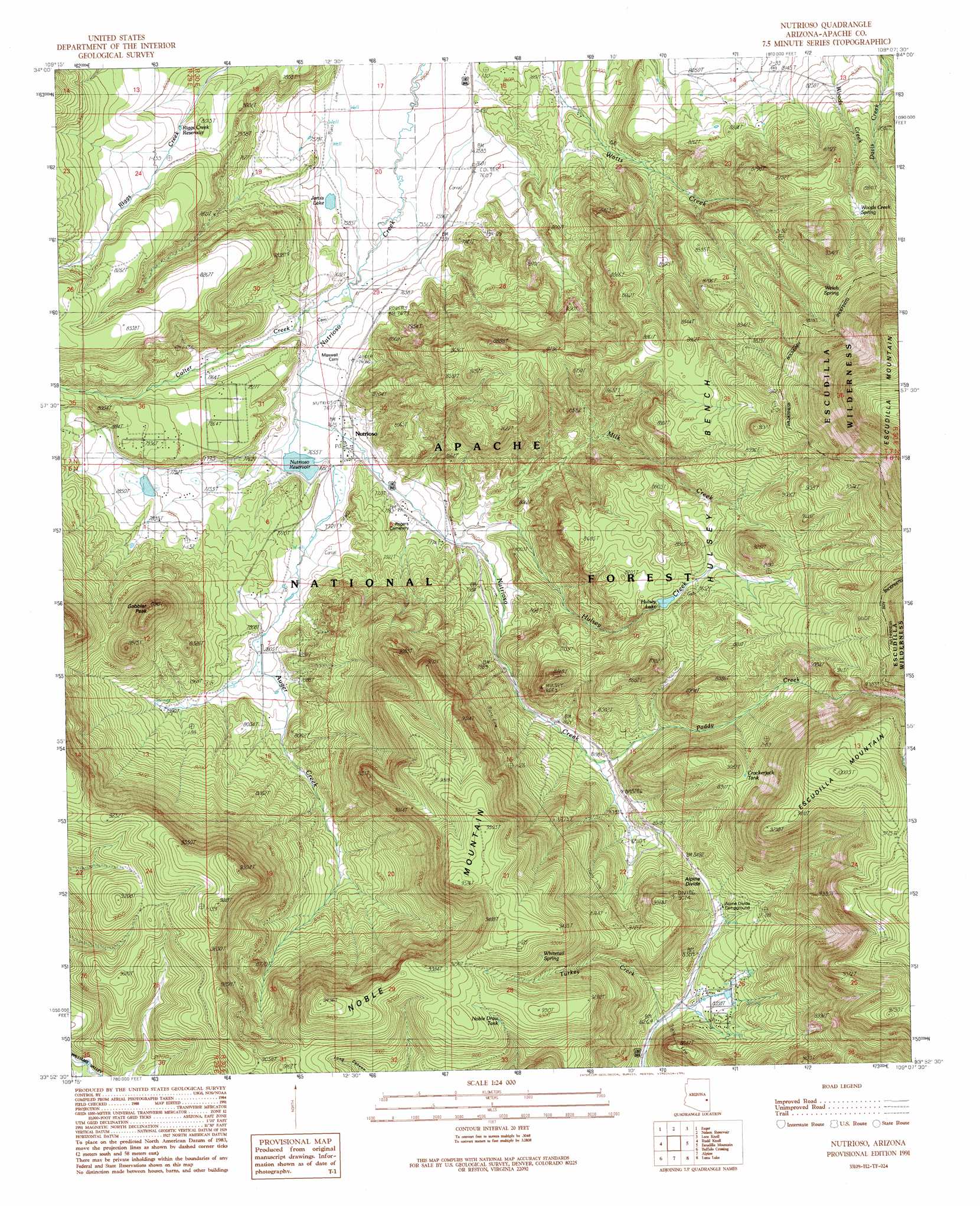
USGS Topo Quad 33109h2 - 1:24,000 scale
| Topo Map Name: | Nutrioso |
| USGS Topo Quad ID: | 33109h2 |
| Print Size: | ca. 21 1/4" wide x 27" high |
| Southeast Coordinates: | 33.875° N latitude / 109.125° W longitude |
| Map Center Coordinates: | 33.9375° N latitude / 109.1875° W longitude |
| U.S. State: | AZ |
| Filename: | o33109h2.jpg |
| Download Map JPG Image: | Nutrioso topo map 1:24,000 scale |
| Map Type: | Topographic |
| Topo Series: | 7.5´ |
| Map Scale: | 1:24,000 |
| Source of Map Images: | United States Geological Survey (USGS) |
| Alternate Map Versions: |
Nutrioso AZ 1991, updated 1991 Download PDF Buy paper map Nutrioso AZ 1997, updated 2000 Download PDF Buy paper map Nutrioso AZ 2011 Download PDF Buy paper map Nutrioso AZ 2014 Download PDF Buy paper map |
| FStopo: | US Forest Service topo Nutrioso is available: Download FStopo PDF Download FStopo TIF |
1:24,000 Topo Quads surrounding Nutrioso
Springerville Nw |
Springerville |
Coyote Hills |
Nelson Reservoir Ne |
Cow Springs |
Greer |
Eagar |
Nelson Reservoir |
Loco Knoll |
Jones Canyon |
Big Lake North |
Rudd Knoll |
Nutrioso |
Escudilla Mountain |
Underwood Lake |
Big Lake South |
Buffalo Crossing |
Alpine |
Luna Lake |
Luna |
Hoodoo Knob |
Hannagan Meadow |
Beaverhead |
Maness Peak |
Bull Basin |
> Back to 33109e1 at 1:100,000 scale
> Back to 33108a1 at 1:250,000 scale
> Back to U.S. Topo Maps home
Nutrioso topo map: Gazetteer
Nutrioso: Benches
Hulsey Bench elevation 2697m 8848′Nutrioso: Dams
Hulsey Lake Dam elevation 2616m 8582′Jarvis Dam elevation 2312m 7585′
Nutrioso Dam elevation 2333m 7654′
Riggs Creek Dam elevation 2434m 7985′
Nutrioso: Lakes
Hulsey Lake elevation 2617m 8585′Nutrioso: Populated Places
Feaster elevation 2503m 8211′Nutrioso elevation 2338m 7670′
Nutrioso: Reservoirs
Crackerjack Tank elevation 2719m 8920′Divide Tank elevation 2609m 8559′
East Section Thirty-five Tank elevation 2754m 9035′
Greenhead Tank elevation 2616m 8582′
Hulsey Fork Tank elevation 2772m 9094′
Hulsey Lake elevation 2616m 8582′
Husley Tank elevation 2647m 8684′
Jarvis Lake elevation 2312m 7585′
Long Draw Tank elevation 2690m 8825′
Long Tank elevation 2716m 8910′
Noble Draw Tank elevation 2807m 9209′
Nutrioso Reservoir elevation 2334m 7657′
Paddy Fork Tank elevation 2835m 9301′
Profanity Tank elevation 2971m 9747′
Riggs Creek Reservoir elevation 2427m 7962′
Rioso Reservoir elevation 2333m 7654′
Road Forks Tank elevation 2610m 8562′
Section 26 Tank elevation 2667m 8750′
Shane Tank elevation 2437m 7995′
Tal-Wi-Wi Tank elevation 2551m 8369′
Trail Tank elevation 2761m 9058′
Turkey Draw Tank elevation 2795m 9169′
West Section Thirty-five Tank elevation 2670m 8759′
Nutrioso: Ridges
Alpine Divide elevation 2602m 8536′Nutrioso: Springs
Alpine Divide Spring elevation 2581m 8467′Carex Spring elevation 2525m 8284′
Charlies Spring elevation 2579m 8461′
Milk Flat Spring elevation 2625m 8612′
Rosebud Cottonwood Cienega Spring elevation 2458m 8064′
Sandy Spring elevation 2589m 8494′
Welch Spring elevation 2822m 9258′
Whitetail Spring elevation 2831m 9288′
Woods Creek Spring elevation 2665m 8743′
Nutrioso: Streams
Auger Creek elevation 2334m 7657′Colter Creek elevation 2315m 7595′
Hulsey Creek elevation 2378m 7801′
Milk Creek elevation 2379m 7805′
Paddy Creek elevation 2491m 8172′
Nutrioso: Summits
Gobbler Peak elevation 2653m 8704′Noble Mountain elevation 2894m 9494′
Nutrioso digital topo map on disk
Buy this Nutrioso topo map showing relief, roads, GPS coordinates and other geographical features, as a high-resolution digital map file on DVD: