Santa Ysabel Topo Map California
To zoom in, hover over the map of Santa Ysabel
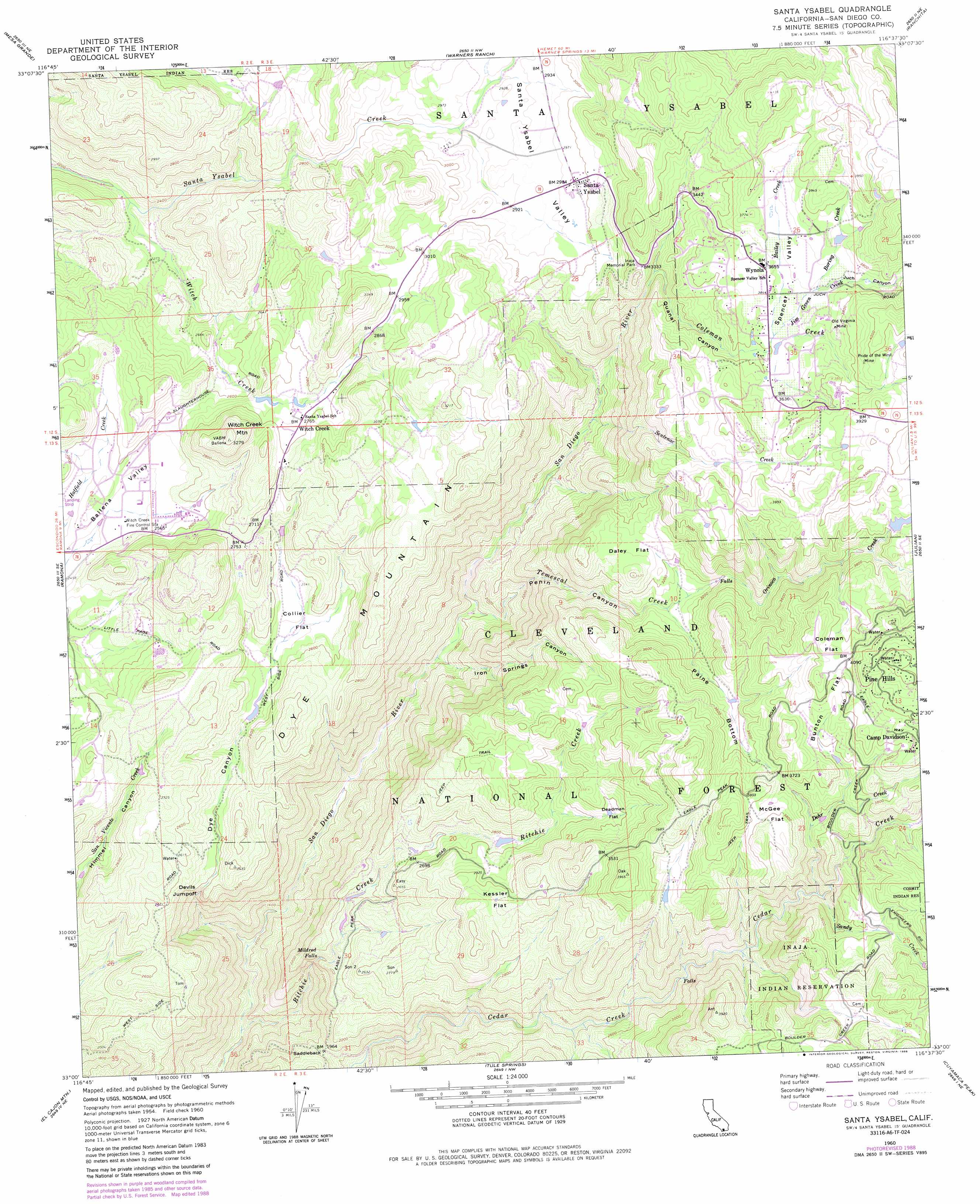
USGS Topo Quad 33116a6 - 1:24,000 scale
| Topo Map Name: | Santa Ysabel |
| USGS Topo Quad ID: | 33116a6 |
| Print Size: | ca. 21 1/4" wide x 27" high |
| Southeast Coordinates: | 33° N latitude / 116.625° W longitude |
| Map Center Coordinates: | 33.0625° N latitude / 116.6875° W longitude |
| U.S. State: | CA |
| Filename: | o33116a6.jpg |
| Download Map JPG Image: | Santa Ysabel topo map 1:24,000 scale |
| Map Type: | Topographic |
| Topo Series: | 7.5´ |
| Map Scale: | 1:24,000 |
| Source of Map Images: | United States Geological Survey (USGS) |
| Alternate Map Versions: |
Santa Ysabel CA 1960, updated 1962 Download PDF Buy paper map Santa Ysabel CA 1960, updated 1969 Download PDF Buy paper map Santa Ysabel CA 1960, updated 1981 Download PDF Buy paper map Santa Ysabel CA 1960, updated 1984 Download PDF Buy paper map Santa Ysabel CA 1960, updated 1988 Download PDF Buy paper map Santa Ysabel CA 1997, updated 2000 Download PDF Buy paper map Santa Ysabel CA 2012 Download PDF Buy paper map Santa Ysabel CA 2015 Download PDF Buy paper map |
| FStopo: | US Forest Service topo Santa Ysabel is available: Download FStopo PDF Download FStopo TIF |
1:24,000 Topo Quads surrounding Santa Ysabel
Boucher Hill |
Palomar Observatory |
Warner Springs |
Hot Springs Mountain |
Borrego Palm Canyon |
Rodriguez Mountain |
Mesa Grande |
Warners Ranch |
Ranchita |
Tubb Canyon |
San Pasqual |
Ramona |
Santa Ysabel |
Julian |
Earthquake Valley |
San Vicente Reservoir |
El Cajon Mountain |
Tule Springs |
Cuyamaca Peak |
Monument Peak |
El Cajon |
Alpine |
Viejas Mountain |
Descanso |
Mount Laguna |
> Back to 33116a1 at 1:100,000 scale
> Back to 33116a1 at 1:250,000 scale
> Back to U.S. Topo Maps home
Santa Ysabel topo map: Gazetteer
Santa Ysabel: Falls
Mildred Falls elevation 696m 2283′Santa Ysabel: Flats
Bunton Flat elevation 1194m 3917′Coleman Flat elevation 1234m 4048′
Collie Flat elevation 772m 2532′
Daley Flat elevation 998m 3274′
Deadman Flat elevation 970m 3182′
Kessler Flat elevation 939m 3080′
McGee Flat elevation 1157m 3795′
Santa Ysabel: Gaps
Saddleback elevation 596m 1955′Santa Ysabel: Mines
Old Virginia Mine elevation 1147m 3763′Pride of the West Mine elevation 1186m 3891′
Santa Ysabel: Parks
Inaja Memorial Park elevation 1018m 3339′Santa Ysabel: Populated Places
Ballena elevation 759m 2490′Pine Hills elevation 1341m 4399′
Santa Ysabel elevation 911m 2988′
Wynola elevation 1111m 3645′
Santa Ysabel: Streams
Bailey Creek elevation 1099m 3605′Boring Creek elevation 1110m 3641′
Coleman Creek elevation 963m 3159′
Dehr Creek elevation 975m 3198′
Jim Green Creek elevation 1100m 3608′
Orinoco Creek elevation 940m 3083′
Ritchie Creek elevation 320m 1049′
Sandy Creek elevation 1005m 3297′
Sentenac Creek elevation 710m 2329′
Temescal Creek elevation 537m 1761′
Witch Creek elevation 677m 2221′
Santa Ysabel: Summits
Dye Mountain elevation 1034m 3392′Witch Creek Mountain elevation 991m 3251′
Santa Ysabel: Trails
Inaja Nature National Recreation Trail elevation 1041m 3415′Santa Ysabel: Valleys
Dye Canyon elevation 450m 1476′Iron Springs Canyon elevation 529m 1735′
Juch Canyon elevation 1119m 3671′
Paine Bottom elevation 940m 3083′
Penin Canyon elevation 539m 1768′
Quanai Canyon elevation 963m 3159′
Santa Ysabel Valley elevation 865m 2837′
Spencer Valley elevation 1099m 3605′
Santa Ysabel digital topo map on disk
Buy this Santa Ysabel topo map showing relief, roads, GPS coordinates and other geographical features, as a high-resolution digital map file on DVD: