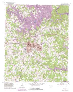
Seneca Topo Map South Carolina
To zoom in, hover over the map of Seneca
USGS Topo Quad 34082f8 - 1:24,000 scale
| Topo Map Name: | Seneca |
| USGS Topo Quad ID: | 34082f8 |
| Print Size: | ca. 21 1/4" wide x 27" high |
| Southeast Coordinates: | 34.625° N latitude / 82.875° W longitude |
| Map Center Coordinates: | 34.6875° N latitude / 82.9375° W longitude |
| U.S. State: | SC |
| Filename: | o34082f8.jpg |
| Download Map JPG Image: | Seneca topo map 1:24,000 scale |
| Map Type: | Topographic |
| Topo Series: | 7.5´ |
| Map Scale: | 1:24,000 |
| Source of Map Images: | United States Geological Survey (USGS) |
| Alternate Map Versions: |
Seneca SC 1958, updated 1961 Download PDF Buy paper map Seneca SC 1958, updated 1964 Download PDF Buy paper map Seneca SC 1958, updated 1980 Download PDF Buy paper map Seneca SC 2011 Download PDF Buy paper map Seneca SC 2014 Download PDF Buy paper map |
1:24,000 Topo Quads surrounding Seneca
> Back to 34082e1 at 1:100,000 scale
> Back to 34082a1 at 1:250,000 scale
> Back to U.S. Topo Maps home
Seneca topo map: Gazetteer
Seneca: Airports
Clemson-Oconee County Airport elevation 277m 908′Seneca: Dams
Little River Dam elevation 244m 800′Little River Dam elevation 244m 800′
Nickols Pond Dam D-1660 elevation 279m 915′
Stephens Coneross Dam elevation 223m 731′
Seneca: Parks
Newry Historic District elevation 218m 715′Seneca Historic District elevation 300m 984′
Seneca: Populated Places
Bent Tree elevation 234m 767′Bishop Heights elevation 305m 1000′
Bounty Land elevation 291m 954′
Brookwood elevation 276m 905′
Cherokee Gardens elevation 251m 823′
Clemson Forest elevation 268m 879′
Cleveland-A-Farm elevation 253m 830′
Clovis Point elevation 262m 859′
Colonial Place elevation 267m 875′
Corinth elevation 276m 905′
Courtenay elevation 289m 948′
Cove Inlet elevation 278m 912′
Dalton elevation 266m 872′
Doris Heights elevation 302m 990′
Eleven Oaks elevation 275m 902′
Enchanted Hills elevation 274m 898′
Fairview elevation 285m 935′
Fairview Shores elevation 280m 918′
Forest Hills elevation 273m 895′
Fox Run elevation 282m 925′
Friendship elevation 270m 885′
George Martin Acres elevation 293m 961′
Gilstrap elevation 295m 967′
Greenbriar elevation 231m 757′
Grover Square elevation 274m 898′
Hampton Shores elevation 259m 849′
Hanover Hills elevation 271m 889′
Harbin Acres elevation 273m 895′
Indian Hills elevation 290m 951′
Indian Oaks elevation 282m 925′
Jordonia elevation 294m 964′
Keowee elevation 244m 800′
Keowee Haven elevation 266m 872′
Keowee Plantation elevation 278m 912′
Keowee Shores elevation 297m 974′
Knoll Wood Manor elevation 276m 905′
Lake Barcroft Acres elevation 273m 895′
Lakeview Heights elevation 290m 951′
Loran Point elevation 279m 915′
Martindale elevation 216m 708′
Millbrook elevation 236m 774′
Mylintee Estates elevation 220m 721′
Newry elevation 230m 754′
Normandy Shores elevation 260m 853′
Oxford elevation 262m 859′
Poplar Cove elevation 222m 728′
Port Santorini elevation 271m 889′
Rackley elevation 286m 938′
Return elevation 280m 918′
Ridgeview elevation 263m 862′
Ridgewood elevation 270m 885′
Royal Acres elevation 229m 751′
Seneca elevation 294m 964′
Seneca Landing elevation 211m 692′
Shadwick elevation 246m 807′
Shiloh elevation 277m 908′
Shiloh Estates elevation 279m 915′
Singing Pines elevation 288m 944′
South Cove elevation 258m 846′
Southern Meadows elevation 288m 944′
Spring Valley elevation 227m 744′
Springbrook elevation 278m 912′
Sunset Shores elevation 280m 918′
The Meadows elevation 247m 810′
The Woods elevation 268m 879′
Thriftwood elevation 262m 859′
Utica elevation 277m 908′
Valley View elevation 235m 770′
Valley View Shores elevation 216m 708′
Village Creek elevation 276m 905′
Vista Grove elevation 254m 833′
Walnut Grove elevation 290m 951′
Water Plantation elevation 268m 879′
Wexford elevation 213m 698′
White Oak Cliffs elevation 279m 915′
Woodburn elevation 290m 951′
Woodcreek elevation 274m 898′
Woodfarm Acres elevation 287m 941′
Woodland Acres elevation 277m 908′
Seneca: Post Offices
Seneca Post Office elevation 296m 971′Seneca: Reservoirs
Coneross Creek Reservoir elevation 223m 731′Keowee Reservoir elevation 244m 800′
Lake Keowee elevation 244m 800′
Mahaffey Lake elevation 244m 800′
McMahons Mill Pond (historical) elevation 244m 800′
Nickols Pond elevation 279m 915′
Sanders Lake elevation 258m 846′
Seneca Reservoir elevation 244m 800′
Webb Lake elevation 244m 800′
Wingos Lake elevation 268m 879′
Seneca: Streams
Cane Creek elevation 244m 800′Crooked Creek elevation 244m 800′
Dodgens Creek elevation 244m 800′
Little River elevation 201m 659′
Perkins Creek elevation 227m 744′
Seneca digital topo map on disk
Buy this Seneca topo map showing relief, roads, GPS coordinates and other geographical features, as a high-resolution digital map file on DVD:
South Carolina, Western North Carolina & Northeastern Georgia
Buy digital topo maps: South Carolina, Western North Carolina & Northeastern Georgia


