Summerville Topo Map Georgia
To zoom in, hover over the map of Summerville
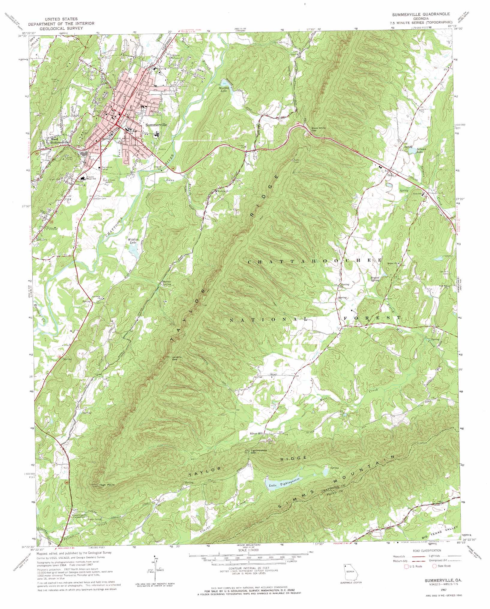
USGS Topo Quad 34085d3 - 1:24,000 scale
| Topo Map Name: | Summerville |
| USGS Topo Quad ID: | 34085d3 |
| Print Size: | ca. 21 1/4" wide x 27" high |
| Southeast Coordinates: | 34.375° N latitude / 85.25° W longitude |
| Map Center Coordinates: | 34.4375° N latitude / 85.3125° W longitude |
| U.S. State: | GA |
| Filename: | o34085d3.jpg |
| Download Map JPG Image: | Summerville topo map 1:24,000 scale |
| Map Type: | Topographic |
| Topo Series: | 7.5´ |
| Map Scale: | 1:24,000 |
| Source of Map Images: | United States Geological Survey (USGS) |
| Alternate Map Versions: |
Summerville GA 1967, updated 1968 Download PDF Buy paper map Summerville GA 2011 Download PDF Buy paper map Summerville GA 2014 Download PDF Buy paper map |
| FStopo: | US Forest Service topo Summerville is available: Download FStopo PDF Download FStopo TIF |
1:24,000 Topo Quads surrounding Summerville
Sulphur Springs |
Cedar Grove |
Estelle |
Catlett |
Villanow |
Valley Head |
Dougherty Gap |
Trion |
Subligna |
Sugar Valley |
Jamestown |
Lyerly |
Summerville |
Armuchee |
Plainville |
Gaylesville |
Chattoogaville |
Rock Mountain |
Rome North |
Shannon |
Cedar Bluff |
Melson |
Livingston |
Rome South |
Wax |
> Back to 34085a1 at 1:100,000 scale
> Back to 34084a1 at 1:250,000 scale
> Back to U.S. Topo Maps home
Summerville topo map: Gazetteer
Summerville: Dams
Lake Tightsqueeze Dam elevation 254m 833′Lower Lake Dam elevation 193m 633′
Maddox Lake Dam elevation 196m 643′
Upper Lake Dam elevation 205m 672′
Wildlife Lake Dam elevation 192m 629′
Summerville: Gaps
Jenkins Gap elevation 421m 1381′Mack White Gap elevation 306m 1003′
Tightsqueeze Gap elevation 294m 964′
Summerville: Parks
Fairway Recreation Center elevation 206m 675′James H Floyd State Park elevation 201m 659′
James H 'Sloppy' Floyd State Park elevation 201m 659′
Summerville Recreation Center elevation 201m 659′
Summerville: Populated Places
Cheney (historical) elevation 264m 866′Gore elevation 217m 711′
Shackelton (historical) elevation 213m 698′
Silver Hill elevation 224m 734′
Storys (historical) elevation 198m 649′
Summerville elevation 198m 649′
West Summerville elevation 218m 715′
Summerville: Post Offices
Summerville Post Office elevation 196m 643′Summerville: Reservoirs
Lake Tightsqueeze elevation 254m 833′Lower Lake elevation 193m 633′
Maddox Lake elevation 196m 643′
Selman Lake elevation 207m 679′
Upper Lake elevation 205m 672′
Wildlife Lake elevation 192m 629′
Summerville: Springs
Bryant Spring elevation 219m 718′Buffington Spring elevation 203m 666′
Marble Spring elevation 202m 662′
Summerville: Streams
Cedar Creek elevation 258m 846′Henry Branch elevation 189m 620′
Lowe Branch elevation 189m 620′
Moss Creek elevation 199m 652′
Raccoon Creek elevation 184m 603′
Town Branch elevation 187m 613′
Summerville: Summits
High Point elevation 468m 1535′Simms Mountain elevation 397m 1302′
Summerville digital topo map on disk
Buy this Summerville topo map showing relief, roads, GPS coordinates and other geographical features, as a high-resolution digital map file on DVD: