Cauthron Topo Map Arkansas
To zoom in, hover over the map of Cauthron
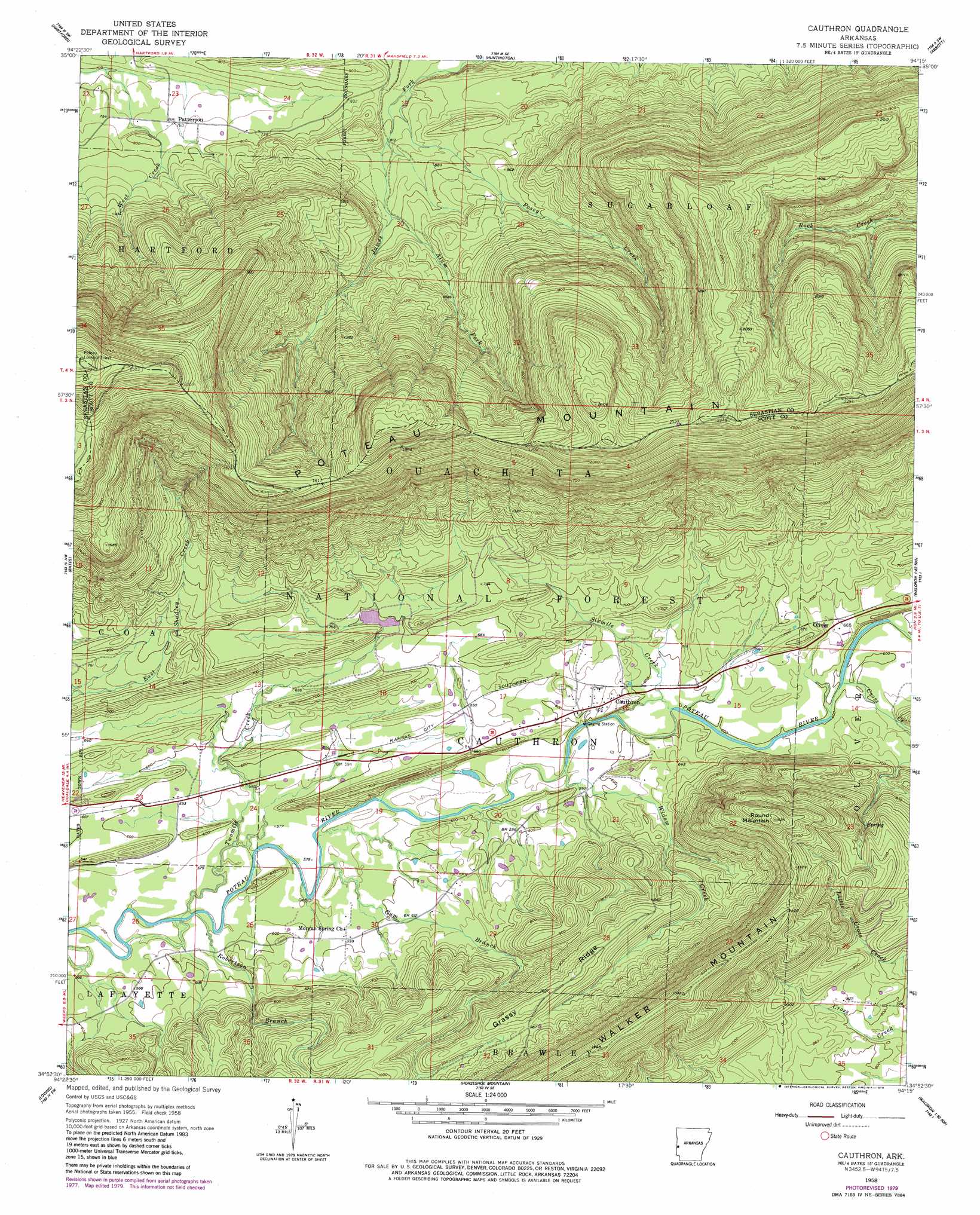
USGS Topo Quad 34094h3 - 1:24,000 scale
| Topo Map Name: | Cauthron |
| USGS Topo Quad ID: | 34094h3 |
| Print Size: | ca. 21 1/4" wide x 27" high |
| Southeast Coordinates: | 34.875° N latitude / 94.25° W longitude |
| Map Center Coordinates: | 34.9375° N latitude / 94.3125° W longitude |
| U.S. State: | AR |
| Filename: | o34094h3.jpg |
| Download Map JPG Image: | Cauthron topo map 1:24,000 scale |
| Map Type: | Topographic |
| Topo Series: | 7.5´ |
| Map Scale: | 1:24,000 |
| Source of Map Images: | United States Geological Survey (USGS) |
| Alternate Map Versions: |
Cauthron AR 1958, updated 1959 Download PDF Buy paper map Cauthron AR 1958, updated 1977 Download PDF Buy paper map Cauthron AR 1958, updated 1979 Download PDF Buy paper map Cauthron AR 2011 Download PDF Buy paper map Cauthron AR 2014 Download PDF Buy paper map |
| FStopo: | US Forest Service topo Cauthron is available: Download FStopo PDF Download FStopo TIF |
1:24,000 Topo Quads surrounding Cauthron
Spiro |
Hackett |
Greenwood |
Burnville |
Barber |
Poteau East |
Hartford |
Huntington |
Abbott |
Ione |
Heavener |
Bates |
Cauthron |
Hon |
Waldron |
Hontubby |
Loving |
Horseshoe Mountain |
Peanut Mountain |
Boles |
Page |
Mountain Fork |
Rich Mountain |
Acorn |
Y City |
> Back to 34094e1 at 1:100,000 scale
> Back to 34094a1 at 1:250,000 scale
> Back to U.S. Topo Maps home
Cauthron topo map: Gazetteer
Cauthron: Dams
Poteau River Watershed Site Nine Dam elevation 212m 695′Cauthron: Populated Places
Cauthron elevation 189m 620′Morgan Springs elevation 183m 600′
Oliver elevation 198m 649′
Patterson elevation 232m 761′
Cauthron: Post Offices
Cauthron Post Office elevation 188m 616′Cauthron: Reservoirs
Poteau River Site Nine Lake elevation 212m 695′Cauthron: Ridges
Grassy Ridge elevation 296m 971′Poteau Mountain elevation 775m 2542′
Cauthron: Streams
Alum Fork elevation 267m 875′Cross Creek elevation 194m 636′
Gum Branch elevation 175m 574′
Jerico Branch elevation 182m 597′
Posey Creek elevation 239m 784′
Robertson Branch elevation 171m 561′
Sixmile Creek elevation 180m 590′
Twomile Creek elevation 173m 567′
Widow Creek elevation 178m 583′
Cauthron: Summits
Poteau Mountain elevation 596m 1955′Poteau Mountain elevation 775m 2542′
Round Mountain elevation 465m 1525′
Walker Mountain elevation 486m 1594′
Cauthron digital topo map on disk
Buy this Cauthron topo map showing relief, roads, GPS coordinates and other geographical features, as a high-resolution digital map file on DVD: