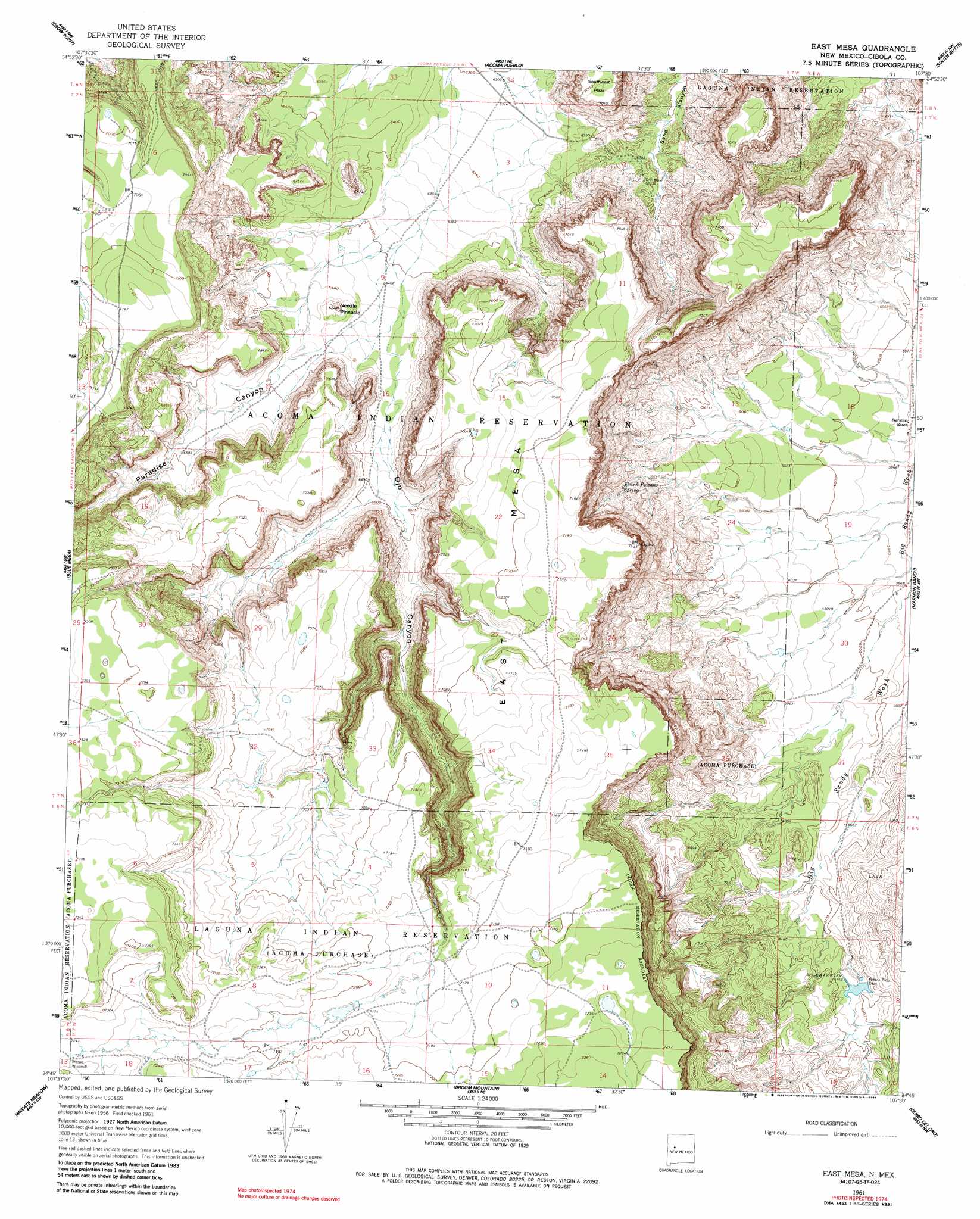
East Mesa Topo Map New Mexico
To zoom in, hover over the map of East Mesa
USGS Topo Quad 34107g5 - 1:24,000 scale
| Topo Map Name: | East Mesa |
| USGS Topo Quad ID: | 34107g5 |
| Print Size: | ca. 21 1/4" wide x 27" high |
| Southeast Coordinates: | 34.75° N latitude / 107.5° W longitude |
| Map Center Coordinates: | 34.8125° N latitude / 107.5625° W longitude |
| U.S. State: | NM |
| Filename: | o34107g5.jpg |
| Download Map JPG Image: | East Mesa topo map 1:24,000 scale |
| Map Type: | Topographic |
| Topo Series: | 7.5´ |
| Map Scale: | 1:24,000 |
| Source of Map Images: | United States Geological Survey (USGS) |
| Alternate Map Versions: |
East Mesa NM 1961, updated 1963 Download PDF Buy paper map East Mesa NM 1961, updated 1984 Download PDF Buy paper map East Mesa NM 2010 Download PDF Buy paper map East Mesa NM 2013 Download PDF Buy paper map East Mesa NM 2017 Download PDF Buy paper map |
1:24,000 Topo Quads surrounding East Mesa
Grants Se |
Mccartys |
Cubero |
Laguna |
Mesita |
Los Pilares |
Crow Point |
Acoma Pueblo |
South Butte |
Dough Mountain |
Laguna Honda |
Blue Mesa |
East Mesa |
Marmon Ranch |
Cerro Verde |
Cebollita Peak |
Mecate Meadow |
Broom Mountain |
Cerro Del Oro |
Chicken Mountain |
Wild Horse Canyon |
Wiley Mesa |
Pueblo Viejo Mesa |
Field Ranch |
Puerto De Los Cavadores |
> Back to 34107e1 at 1:100,000 scale
> Back to 34106a1 at 1:250,000 scale
> Back to U.S. Topo Maps home
East Mesa topo map: Gazetteer
East Mesa: Benches
East Mesa elevation 2166m 7106′East Mesa: Dams
Petaca Pinta Dam elevation 1877m 6158′East Mesa: Pillars
Needle Pinnacle elevation 2017m 6617′East Mesa: Springs
Frank Paisano Spring elevation 1925m 6315′East Mesa: Summits
Southwest Plaza elevation 2141m 7024′East Mesa: Valleys
Ojo Canyon elevation 1954m 6410′Paradise Canyon elevation 1960m 6430′
East Mesa: Wells
Acoma Number 6 Water Well elevation 2136m 7007′East Mesa digital topo map on disk
Buy this East Mesa topo map showing relief, roads, GPS coordinates and other geographical features, as a high-resolution digital map file on DVD: