Big Shipp Mountain Topo Map Arizona
To zoom in, hover over the map of Big Shipp Mountain
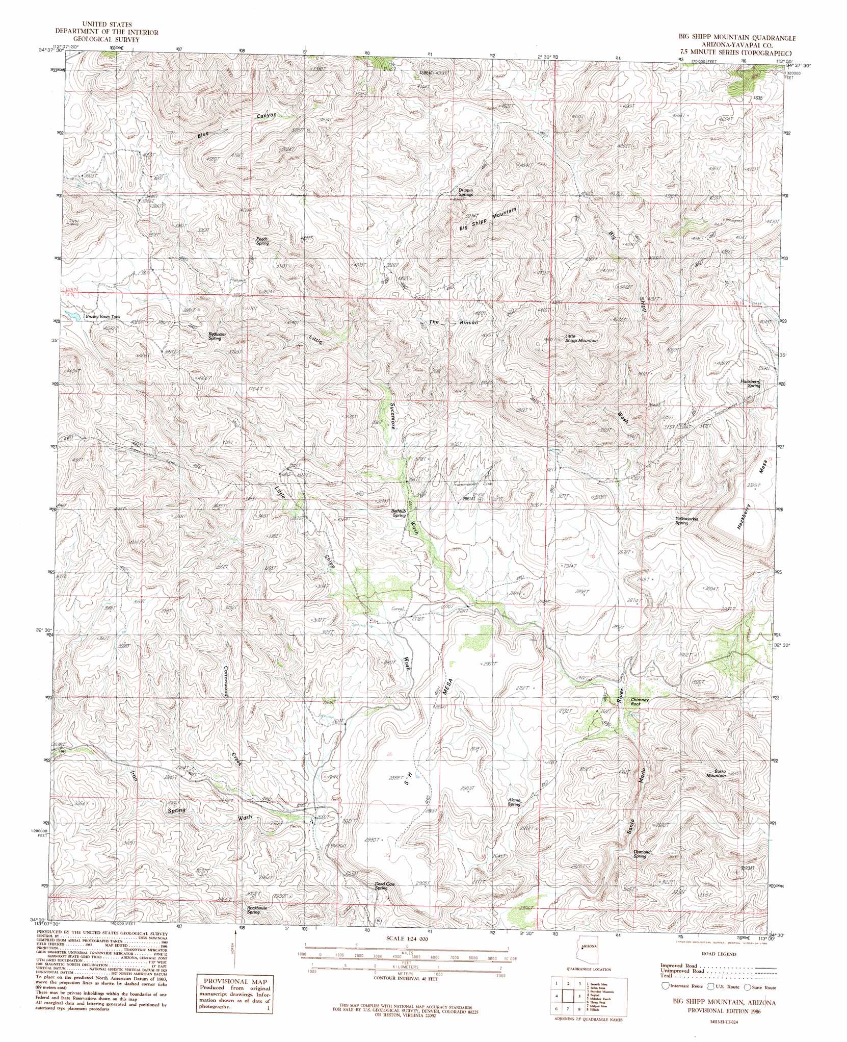
USGS Topo Quad 34113e1 - 1:24,000 scale
| Topo Map Name: | Big Shipp Mountain |
| USGS Topo Quad ID: | 34113e1 |
| Print Size: | ca. 21 1/4" wide x 27" high |
| Southeast Coordinates: | 34.5° N latitude / 113° W longitude |
| Map Center Coordinates: | 34.5625° N latitude / 113.0625° W longitude |
| U.S. State: | AZ |
| Filename: | o34113e1.jpg |
| Download Map JPG Image: | Big Shipp Mountain topo map 1:24,000 scale |
| Map Type: | Topographic |
| Topo Series: | 7.5´ |
| Map Scale: | 1:24,000 |
| Source of Map Images: | United States Geological Survey (USGS) |
| Alternate Map Versions: |
Big Shipp Mountain AZ 1986, updated 1986 Download PDF Buy paper map Big Shipp Mountain AZ 2011 Download PDF Buy paper map Big Shipp Mountain AZ 2014 Download PDF Buy paper map |
1:24,000 Topo Quads surrounding Big Shipp Mountain
Pilot Knob |
Burro Mesa |
Scratch Canyon |
Camp Wood |
Seepage Mountain |
Negro Ed |
Bozarth Mesa |
Behm Mesa |
Sheridan Mountain |
Smith Mesa |
Grayback Mountains |
Bagdad |
Big Shipp Mountain |
Muleshoe Ranch |
Martin Mountain |
Arrastra Mountain Ne |
Thorn Peak |
Malpais Mesa Ne |
Hillside |
Bismarck Mesa |
Arrastra Mountain Se |
Ives Peak |
Malpais Mesa |
Date |
Weaver Peak |
> Back to 34113e1 at 1:100,000 scale
> Back to 34112a1 at 1:250,000 scale
> Back to U.S. Topo Maps home
Big Shipp Mountain topo map: Gazetteer
Big Shipp Mountain: Areas
Muchos Cañones elevation 782m 2565′Big Shipp Mountain: Basins
The Rincon elevation 1197m 3927′Big Shipp Mountain: Pillars
Chimney Rock elevation 805m 2641′Big Shipp Mountain: Streams
Big Shipp Wash elevation 793m 2601′Cottonwood Creek elevation 779m 2555′
Iron Spring Wash elevation 780m 2559′
Little Sycamore Wash elevation 781m 2562′
Big Shipp Mountain: Summits
Big Shipp Mountain elevation 1571m 5154′Burro Mountain elevation 1076m 3530′
Hackberry Mesa elevation 1147m 3763′
Little Shipp Mountain elevation 1477m 4845′
S H Mesa elevation 0m 0′
Big Shipp Mountain: Valleys
Blue Canyon elevation 1144m 3753′Big Shipp Mountain digital topo map on disk
Buy this Big Shipp Mountain topo map showing relief, roads, GPS coordinates and other geographical features, as a high-resolution digital map file on DVD: