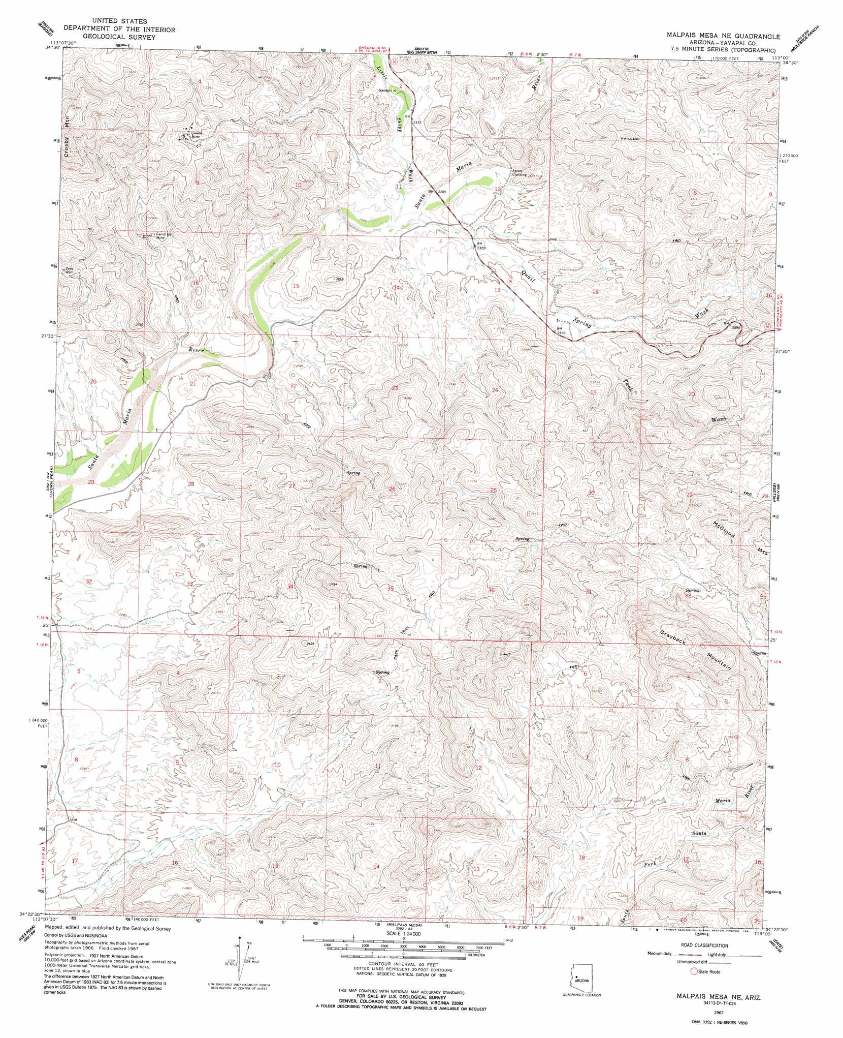
Malpais Mesa Ne Topo Map Arizona
To zoom in, hover over the map of Malpais Mesa Ne
USGS Topo Quad 34113d1 - 1:24,000 scale
| Topo Map Name: | Malpais Mesa Ne |
| USGS Topo Quad ID: | 34113d1 |
| Print Size: | ca. 21 1/4" wide x 27" high |
| Southeast Coordinates: | 34.375° N latitude / 113° W longitude |
| Map Center Coordinates: | 34.4375° N latitude / 113.0625° W longitude |
| U.S. State: | AZ |
| Filename: | o34113d1.jpg |
| Download Map JPG Image: | Malpais Mesa Ne topo map 1:24,000 scale |
| Map Type: | Topographic |
| Topo Series: | 7.5´ |
| Map Scale: | 1:24,000 |
| Source of Map Images: | United States Geological Survey (USGS) |
| Alternate Map Versions: |
Malpais Mesa NE AZ 1967, updated 1970 Download PDF Buy paper map Malpais Mesa NE AZ 1967, updated 1991 Download PDF Buy paper map Malpais Mesa NE AZ 2011 Download PDF Buy paper map Malpais Mesa NE AZ 2014 Download PDF Buy paper map |
1:24,000 Topo Quads surrounding Malpais Mesa Ne
Negro Ed |
Bozarth Mesa |
Behm Mesa |
Sheridan Mountain |
Smith Mesa |
Grayback Mountains |
Bagdad |
Big Shipp Mountain |
Muleshoe Ranch |
Martin Mountain |
Arrastra Mountain Ne |
Thorn Peak |
Malpais Mesa Ne |
Hillside |
Bismarck Mesa |
Arrastra Mountain Se |
Ives Peak |
Malpais Mesa |
Date |
Weaver Peak |
Smith Peak Ne |
Date Creek Ranch Nw |
Date Creek Ranch |
O'Neill Pass |
Congress |
> Back to 34113a1 at 1:100,000 scale
> Back to 34112a1 at 1:250,000 scale
> Back to U.S. Topo Maps home
Malpais Mesa Ne topo map: Gazetteer
Malpais Mesa Ne: Mines
Crosby Mine elevation 977m 3205′Swiss Bell Mine elevation 790m 2591′
Malpais Mesa Ne: Populated Places
Apron Crossing elevation 701m 2299′Malpais Mesa Ne: Streams
Little Shipp Wash elevation 690m 2263′Quail Spring Wash elevation 688m 2257′
Tank Wash elevation 744m 2440′
Malpais Mesa Ne: Summits
Grayback Mountain elevation 1400m 4593′Malpais Mesa Ne: Wells
Deer Well elevation 870m 2854′Malpais Mesa Ne digital topo map on disk
Buy this Malpais Mesa Ne topo map showing relief, roads, GPS coordinates and other geographical features, as a high-resolution digital map file on DVD: