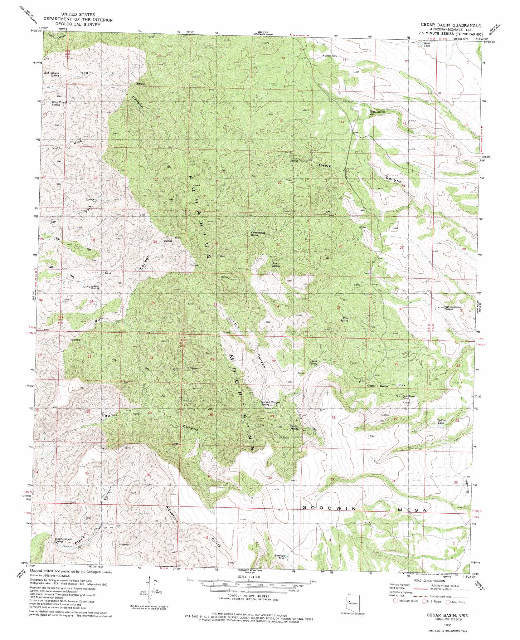
Cedar Basin Topo Map Arizona
To zoom in, hover over the map of Cedar Basin
USGS Topo Quad 34113g4 - 1:24,000 scale
| Topo Map Name: | Cedar Basin |
| USGS Topo Quad ID: | 34113g4 |
| Print Size: | ca. 21 1/4" wide x 27" high |
| Southeast Coordinates: | 34.75° N latitude / 113.375° W longitude |
| Map Center Coordinates: | 34.8125° N latitude / 113.4375° W longitude |
| U.S. State: | AZ |
| Filename: | o34113g4.jpg |
| Download Map JPG Image: | Cedar Basin topo map 1:24,000 scale |
| Map Type: | Topographic |
| Topo Series: | 7.5´ |
| Map Scale: | 1:24,000 |
| Source of Map Images: | United States Geological Survey (USGS) |
| Alternate Map Versions: |
Cedar Basin AZ 1980, updated 1980 Download PDF Buy paper map Cedar Basin AZ 2011 Download PDF Buy paper map Cedar Basin AZ 2014 Download PDF Buy paper map |
1:24,000 Topo Quads surrounding Cedar Basin
Bottleneck Wash |
Austin Peak |
Penitentiary Mountain |
Devils Hump |
Anvil Rock Ranch |
Pilgrim Wash |
Tom Brown Canyon |
Gonzales Wash |
Mohon Peak |
Sunrise Peak |
Gunsight Canyon |
Tule Wash |
Cedar Basin |
Pilot Knob |
Burro Mesa |
Aubrey Peak |
Wikieup |
Elephant Mountain |
Negro Ed |
Bozarth Mesa |
Groom Spring |
Greenwood Peak |
Kaiser Spring |
Grayback Mountains |
Bagdad |
> Back to 34113e1 at 1:100,000 scale
> Back to 34112a1 at 1:250,000 scale
> Back to U.S. Topo Maps home
Cedar Basin topo map: Gazetteer
Cedar Basin: Basins
Cedar Basin elevation 1400m 4593′Cedar Basin: Cliffs
Aquarius Cliffs elevation 1187m 3894′Cedar Basin: Reservoirs
Antelope Tank elevation 1631m 5351′Mesa Tank elevation 1400m 4593′
Shelton Tank elevation 0m 0′
Cedar Basin: Springs
Black Canyon Spring elevation 1039m 3408′Blue Spring elevation 1439m 4721′
Cottonwood Spring elevation 1626m 5334′
Gordon Canyon Spring elevation 1453m 4767′
Long Trough Spring elevation 1426m 4678′
Oak Spring elevation 1444m 4737′
Red Canyon Spring elevation 1416m 4645′
Sam Spring elevation 1604m 5262′
Walnut Spring elevation 1468m 4816′
Williams Spring elevation 1634m 5360′
Cedar Basin: Valleys
Black Canyon elevation 1029m 3375′Gordon Canyon elevation 1388m 4553′
Cedar Basin: Wells
High-Lonesome Windmill elevation 1383m 4537′Sunburn Windmill elevation 1312m 4304′
Willow Springs Well elevation 1404m 4606′
Cedar Basin digital topo map on disk
Buy this Cedar Basin topo map showing relief, roads, GPS coordinates and other geographical features, as a high-resolution digital map file on DVD: