Washington Topo Map North Carolina
To zoom in, hover over the map of Washington
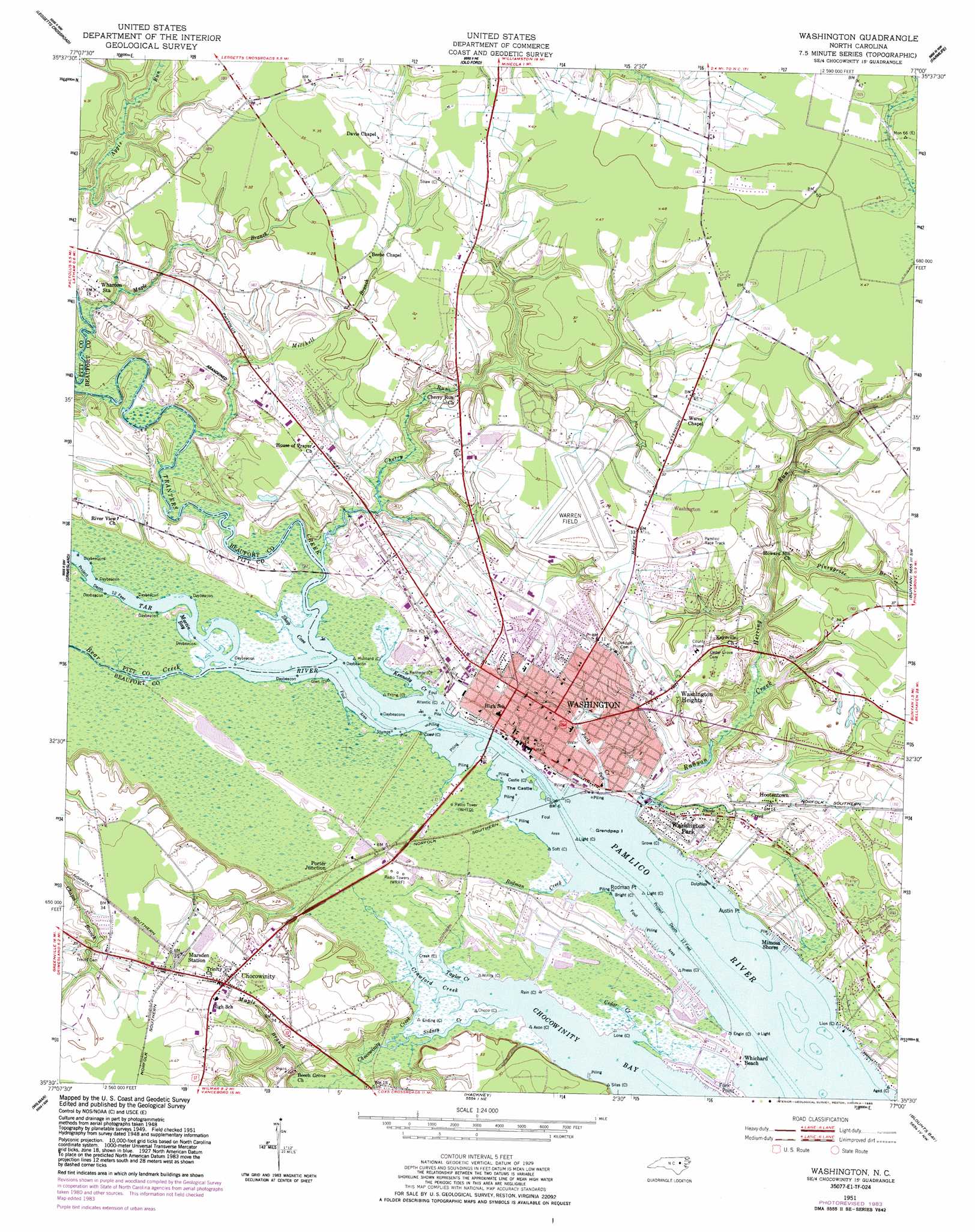
USGS Topo Quad 35077e1 - 1:24,000 scale
| Topo Map Name: | Washington |
| USGS Topo Quad ID: | 35077e1 |
| Print Size: | ca. 21 1/4" wide x 27" high |
| Southeast Coordinates: | 35.5° N latitude / 77° W longitude |
| Map Center Coordinates: | 35.5625° N latitude / 77.0625° W longitude |
| U.S. State: | NC |
| Filename: | o35077e1.jpg |
| Download Map JPG Image: | Washington topo map 1:24,000 scale |
| Map Type: | Topographic |
| Topo Series: | 7.5´ |
| Map Scale: | 1:24,000 |
| Source of Map Images: | United States Geological Survey (USGS) |
| Alternate Map Versions: |
Washington NC 1951, updated 1959 Download PDF Buy paper map Washington NC 1951, updated 1977 Download PDF Buy paper map Washington NC 1951, updated 1983 Download PDF Buy paper map Washington NC 2010 Download PDF Buy paper map Washington NC 2013 Download PDF Buy paper map Washington NC 2016 Download PDF Buy paper map |
1:24,000 Topo Quads surrounding Washington
Robersonville West |
Robersonville East |
Williamston |
Jamesville |
Plymouth West |
Greenville Ne |
Leggetts Crossroads |
Old Ford |
Farmlife |
Hoke |
Greenville Se |
Grimesland |
Washington |
Bunyan |
Pinetown |
Gardnerville |
Wilmar |
Hackney |
Blounts Bay |
Bath |
Fort Barnwell |
Vanceboro |
Ernul |
Edward |
Aurora |
> Back to 35077e1 at 1:100,000 scale
> Back to 35076a1 at 1:250,000 scale
> Back to U.S. Topo Maps home
Washington topo map: Gazetteer
Washington: Airports
Warren Field elevation 10m 32′Washington: Bays
Chocowinity Bay elevation 0m 0′Martin Bay elevation 0m 0′
Shop Cove elevation -1m -4′
Washington: Capes
Austin Point elevation 1m 3′Rodman Point elevation 0m 0′
Washington: Islands
Grandpap Island elevation -1m -4′The Castle elevation 0m 0′
Washington: Populated Places
Chocowinity elevation 12m 39′Elks Mobile Home Park elevation 9m 29′
Hootentown elevation 4m 13′
Maryanna Mobile Estates elevation 4m 13′
Mimosa Manor Mobile Home Park elevation 2m 6′
Mimosa Shores elevation 2m 6′
Porter elevation 5m 16′
Porter Junction elevation 1m 3′
Rosedale elevation 3m 9′
Smallwood elevation 10m 32′
Twin Lakes Resort elevation 1m 3′
Washington elevation 2m 6′
Washington Heights elevation 9m 29′
Washington Park elevation 2m 6′
Whichard Beach elevation 1m 3′
Washington: Streams
Bear Creek elevation 0m 0′Cedar Creek elevation 0m 0′
Cherry Run elevation -1m -4′
Chocowinity Creek elevation 0m 0′
Crawford Creek elevation 0m 0′
Herring Run elevation 1m 3′
Jacks Creek elevation -1m -4′
Kennedy Creek elevation 0m 0′
Maple Branch elevation -1m -4′
Maple Branch elevation 1m 3′
Mitchell Branch elevation 0m 0′
Pineygrove Branch elevation 2m 6′
Rodman Creek elevation 0m 0′
Runyon Creek elevation -1m -4′
Sidney Creek elevation 0m 0′
Tar River elevation 0m 0′
Taylor Creek elevation 0m 0′
Tranters Creek elevation 0m 0′
Washington digital topo map on disk
Buy this Washington topo map showing relief, roads, GPS coordinates and other geographical features, as a high-resolution digital map file on DVD:
Atlantic Coast (NY, NJ, PA, DE, MD, VA, NC)
Buy digital topo maps: Atlantic Coast (NY, NJ, PA, DE, MD, VA, NC)
 map DVD")