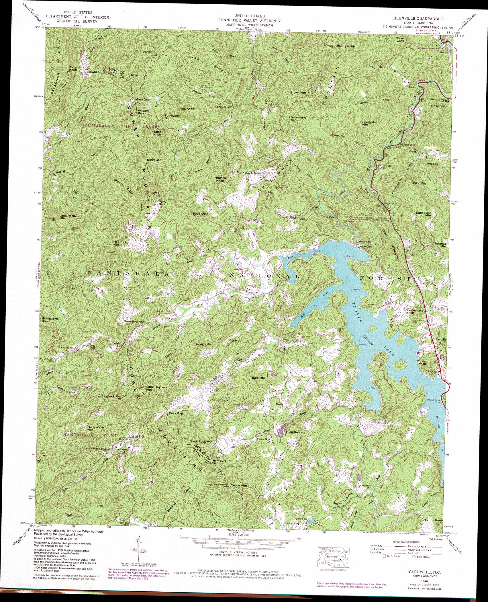
Glenville Topo Map North Carolina
To zoom in, hover over the map of Glenville
USGS Topo Quad 35083b2 - 1:24,000 scale
| Topo Map Name: | Glenville |
| USGS Topo Quad ID: | 35083b2 |
| Print Size: | ca. 21 1/4" wide x 27" high |
| Southeast Coordinates: | 35.125° N latitude / 83.125° W longitude |
| Map Center Coordinates: | 35.1875° N latitude / 83.1875° W longitude |
| U.S. State: | NC |
| Filename: | o35083b2.jpg |
| Download Map JPG Image: | Glenville topo map 1:24,000 scale |
| Map Type: | Topographic |
| Topo Series: | 7.5´ |
| Map Scale: | 1:24,000 |
| Source of Map Images: | United States Geological Survey (USGS) |
| Alternate Map Versions: |
Glenville NC 1935 Download PDF Buy paper map Glenville NC 1946, updated 1956 Download PDF Buy paper map Glenville NC 1946, updated 1966 Download PDF Buy paper map Glenville NC 1946, updated 1970 Download PDF Buy paper map Glenville NC 1946, updated 1972 Download PDF Buy paper map Glenville NC 1946, updated 1980 Download PDF Buy paper map Glenville NC 1946, updated 1984 Download PDF Buy paper map Glenville NC 1946, updated 1984 Download PDF Buy paper map Glenville NC 1947, updated 1947 Download PDF Buy paper map Glenville NC 1947, updated 1947 Download PDF Buy paper map Glenville NC 2011 Download PDF Buy paper map Glenville NC 2013 Download PDF Buy paper map Glenville NC 2016 Download PDF Buy paper map |
| FStopo: | US Forest Service topo Glenville is available: Download FStopo PDF Download FStopo TIF |
1:24,000 Topo Quads surrounding Glenville
Bryson City |
Whittier |
Sylva North |
Hazelwood |
Waynesville |
Alarka |
Greens Creek |
Sylva South |
Tuckasegee |
Sam Knob |
Franklin |
Corbin Knob |
Glenville |
Big Ridge |
Lake Toxaway |
Prentiss |
Scaly Mountain |
Highlands |
Cashiers |
Reid |
Dillard |
Rabun Bald |
Satolah |
Tamassee |
Salem |
> Back to 35083a1 at 1:100,000 scale
> Back to 35082a1 at 1:250,000 scale
> Back to U.S. Topo Maps home
Glenville topo map: Gazetteer
Glenville: Cliffs
Cedar Cliffs elevation 935m 3067′Glenville: Dams
Glenville Dam elevation 1062m 3484′Thorpe Dam elevation 1068m 3503′
Glenville: Falls
Betsy Falls elevation 885m 2903′High Falls elevation 908m 2979′
Onion Falls elevation 1033m 3389′
Thurston Hatcher Falls elevation 892m 2926′
Glenville: Gaps
Berry Gap elevation 1259m 4130′Buck Gap elevation 1232m 4041′
Cullowhee Gap elevation 1144m 3753′
Hamburg Gap elevation 1331m 4366′
Moss Gap elevation 1180m 3871′
Perry Gap elevation 1338m 4389′
Turkeypen Gap elevation 1162m 3812′
Walnut Gap elevation 1246m 4087′
Glenville: Populated Places
Bessie elevation 1227m 4025′Erastus elevation 1084m 3556′
Glenville elevation 1097m 3599′
Norton elevation 1116m 3661′
Shookville elevation 1018m 3339′
Glenville: Reservoirs
Allison Lake elevation 1120m 3674′Hidden Lake elevation 1148m 3766′
Lake Glenville elevation 1062m 3484′
Glenville: Ridges
Brushy Ridge elevation 1256m 4120′Low Ridge elevation 1098m 3602′
Glenville: Streams
Bearpen Branch elevation 944m 3097′Betsy Branch elevation 806m 2644′
Bryson Branch elevation 915m 3001′
Coggins Creek elevation 853m 2798′
Dodgen Creek elevation 817m 2680′
Flat Creek elevation 1128m 3700′
Gem Creek elevation 1077m 3533′
Grassy Camp Creek elevation 1085m 3559′
Grassy Creek elevation 721m 2365′
Hunter Jim Creek elevation 774m 2539′
Hurricane Creek elevation 1062m 3484′
Jackson Creek elevation 1113m 3651′
Joe Creek elevation 814m 2670′
Knob Creek elevation 1088m 3569′
Laurel Branch elevation 1077m 3533′
Little Mill Creek elevation 711m 2332′
Little Mill Creek elevation 720m 2362′
Little Pine Creek elevation 1075m 3526′
Little Salt Rock Creek elevation 849m 2785′
Mill Creek elevation 1062m 3484′
Norton Creek elevation 1085m 3559′
Pine Creek elevation 1062m 3484′
Rough Run elevation 866m 2841′
Shoal Creek elevation 794m 2604′
Taylor Creek elevation 1108m 3635′
Trout Creek elevation 742m 2434′
Whiterock Creek elevation 904m 2965′
Wilson Creek elevation 732m 2401′
Wolf Creek elevation 727m 2385′
Glenville: Summits
Bald Mountain elevation 1317m 4320′Big Mountain elevation 1402m 4599′
Black Rock Mountain elevation 1496m 4908′
Brown Mountain elevation 1182m 3877′
Buck Knob elevation 1409m 4622′
Buck Water Mountain elevation 1367m 4484′
Cherry Knob elevation 1297m 4255′
Chestnut Mountain elevation 1311m 4301′
Eagle Knob elevation 1372m 4501′
Grindstone Knob elevation 1267m 4156′
High Knob elevation 1317m 4320′
Hogback Mountain elevation 1502m 4927′
Hughes Knob elevation 1309m 4294′
Kirby Knob elevation 1354m 4442′
Laurel Knob elevation 1223m 4012′
Little Hogback Mountain elevation 1499m 4917′
Little Pilot Mountain elevation 1220m 4002′
Little Rocky Mountain elevation 1211m 3973′
Moss Knob elevation 1329m 4360′
Old Rocky Mountain elevation 1460m 4790′
Pilot Mountain elevation 1224m 4015′
Pine Knob elevation 1232m 4041′
Potato Knob elevation 1191m 3907′
Prickly Ash Mountain elevation 1096m 3595′
Rattlesnake Knob elevation 1166m 3825′
Rough Mountain elevation 1410m 4625′
Shoal Mountain elevation 1267m 4156′
Snowbird Mountain elevation 1385m 4543′
Wildcat Knob elevation 1269m 4163′
Wolf Knob elevation 1455m 4773′
Yellow Mountain elevation 1557m 5108′
Glenville digital topo map on disk
Buy this Glenville topo map showing relief, roads, GPS coordinates and other geographical features, as a high-resolution digital map file on DVD:
South Carolina, Western North Carolina & Northeastern Georgia
Buy digital topo maps: South Carolina, Western North Carolina & Northeastern Georgia