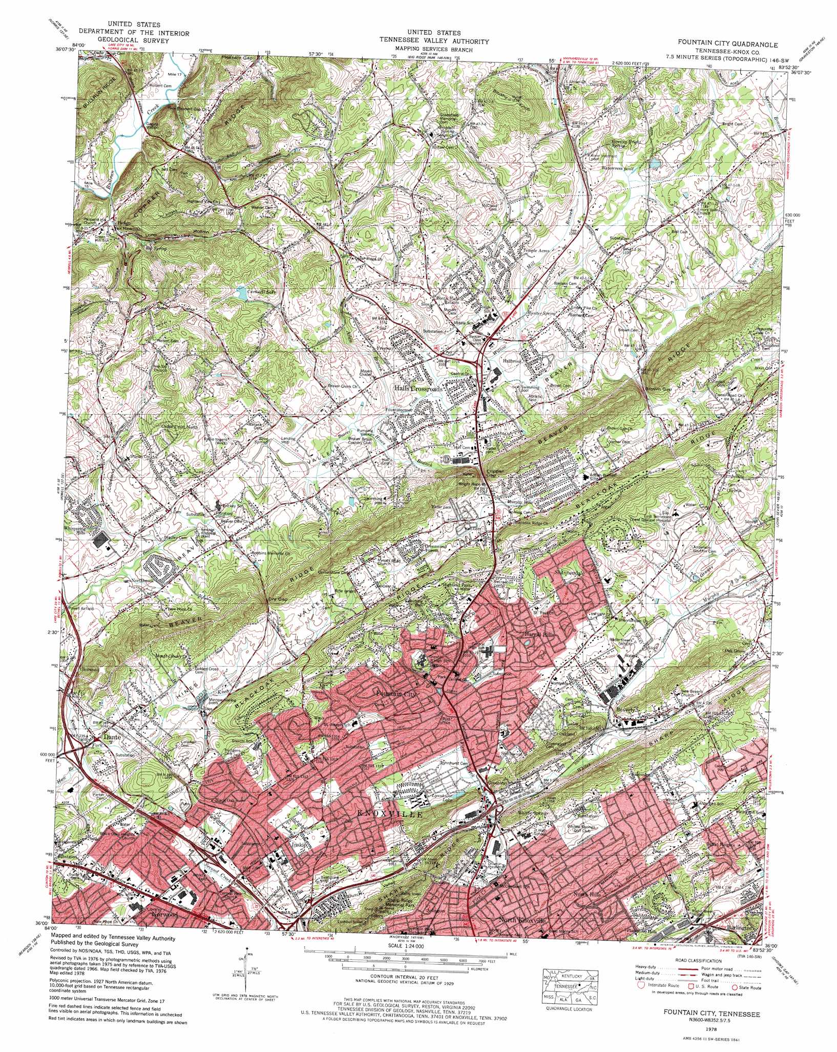
Fountain City Topo Map Tennessee
To zoom in, hover over the map of Fountain City
USGS Topo Quad 36083a8 - 1:24,000 scale
| Topo Map Name: | Fountain City |
| USGS Topo Quad ID: | 36083a8 |
| Print Size: | ca. 21 1/4" wide x 27" high |
| Southeast Coordinates: | 36° N latitude / 83.875° W longitude |
| Map Center Coordinates: | 36.0625° N latitude / 83.9375° W longitude |
| U.S. State: | TN |
| Filename: | o36083a8.jpg |
| Download Map JPG Image: | Fountain City topo map 1:24,000 scale |
| Map Type: | Topographic |
| Topo Series: | 7.5´ |
| Map Scale: | 1:24,000 |
| Source of Map Images: | United States Geological Survey (USGS) |
| Alternate Map Versions: |
Fountain City TN 1935 Download PDF Buy paper map Fountain City TN 1941 Download PDF Buy paper map Fountain City TN 1953, updated 1954 Download PDF Buy paper map Fountain City TN 1953, updated 1955 Download PDF Buy paper map Fountain City TN 1958, updated 1979 Download PDF Buy paper map Fountain City TN 1966, updated 1968 Download PDF Buy paper map Fountain City TN 1978, updated 1979 Download PDF Buy paper map Fountain City TN 1978, updated 1979 Download PDF Buy paper map Fountain City TN 2010 Download PDF Buy paper map Fountain City TN 2013 Download PDF Buy paper map Fountain City TN 2016 Download PDF Buy paper map |
1:24,000 Topo Quads surrounding Fountain City
Jacksboro |
Demory |
White Hollow |
Maynardville |
Powder Springs |
Lake City |
Norris |
Big Ridge Park |
Graveston |
Luttrell |
Clinton |
Powell |
Fountain City |
John Sevier |
Mascot |
Lovell |
Bearden |
Knoxville |
Shooks Gap |
Boyds Creek |
Concord |
Louisville |
Maryville |
Wildwood |
Walden Creek |
> Back to 36083a1 at 1:100,000 scale
> Back to 36082a1 at 1:250,000 scale
> Back to U.S. Topo Maps home
Fountain City topo map: Gazetteer
Fountain City: Crossings
Interchange 10 elevation 310m 1017′Interchange 108 elevation 311m 1020′
Interchange 6 elevation 292m 958′
Interchange 8 elevation 313m 1026′
Fountain City: Gaps
Brown Gap elevation 315m 1033′Crippen Gap elevation 325m 1066′
Dry Gap elevation 352m 1154′
Holbert Gap elevation 269m 882′
Pleasant Gap elevation 294m 964′
Fountain City: Lakes
Watercress Pond elevation 322m 1056′Fountain City: Parks
Fountain City Park elevation 298m 977′Mead Park elevation 307m 1007′
Sharp Ridge Memorial Park elevation 380m 1246′
Fountain City: Populated Places
Arlington elevation 303m 994′Beverly elevation 303m 994′
Beverly Acres elevation 341m 1118′
Black Oak elevation 339m 1112′
Blueberry Hills elevation 402m 1318′
Bonta Vista Estates elevation 336m 1102′
Briarwood Estates elevation 323m 1059′
Buffat Heights elevation 318m 1043′
Cedar Crest North elevation 345m 1131′
Cedar Flats elevation 328m 1076′
Cedar Grove elevation 274m 898′
Cedarchase elevation 324m 1062′
Corinth elevation 343m 1125′
Dante elevation 310m 1017′
Dogwood Mobile Home Park elevation 343m 1125′
Dry Gap elevation 309m 1013′
Emory Estates elevation 361m 1184′
Fieldview elevation 319m 1046′
Fountain City elevation 300m 984′
Fountaincrest elevation 314m 1030′
Freeway elevation 330m 1082′
Fults Trailer Park elevation 360m 1181′
Greenway elevation 299m 980′
Greenwood Forest elevation 337m 1105′
Hallbrook elevation 312m 1023′
Halls elevation 310m 1017′
Halls And Powell Mobile Home Park elevation 312m 1023′
Halls Crossroads elevation 320m 1049′
Harrill Hills elevation 315m 1033′
Highland Park elevation 364m 1194′
Highland View elevation 367m 1204′
Homestead elevation 320m 1049′
Huntingdon Place elevation 343m 1125′
Inskip elevation 320m 1049′
Mapleview elevation 394m 1292′
Mill Run elevation 332m 1089′
Murphy Hills elevation 337m 1105′
Mynatt elevation 334m 1095′
North Hills elevation 335m 1099′
North Knoxville elevation 322m 1056′
Northbrook elevation 312m 1023′
Northridge Estates elevation 328m 1076′
Norwood elevation 324m 1062′
Oak Grove elevation 310m 1017′
Oak Park elevation 346m 1135′
Oakland elevation 309m 1013′
Pedigo elevation 269m 882′
Pinewood Trailer Park elevation 348m 1141′
Plantation Hills elevation 313m 1026′
Preston (historical) elevation 351m 1151′
Rifle Range Estates elevation 341m 1118′
Shannondale elevation 343m 1125′
Smithwood elevation 306m 1003′
Still Brook elevation 334m 1095′
Temple Acres elevation 335m 1099′
Tillery Drive Mobile Home Park elevation 320m 1049′
Timber Line Estates elevation 383m 1256′
Villa Gardens elevation 354m 1161′
Whispering Hills elevation 313m 1026′
Whittle Springs elevation 321m 1053′
Fountain City: Post Offices
Fountain City Post Office elevation 293m 961′Norwood Post Office elevation 327m 1072′
Fountain City: Reservoirs
Cardwell Lake elevation 347m 1138′Lynnhurst Lake elevation 293m 961′
Fountain City: Ridges
Sharp Ridge elevation 366m 1200′Fountain City: Springs
Big Spring elevation 293m 961′Big Spring elevation 311m 1020′
Blue Spring elevation 304m 997′
Community Spring elevation 316m 1036′
Deep Spring elevation 307m 1007′
Granny Bright Spring elevation 323m 1059′
Graybell Spring elevation 368m 1207′
Hobbs Spring elevation 353m 1158′
Hunter Spring elevation 312m 1023′
Fountain City: Streams
Allen Branch elevation 307m 1007′Copper Ridge Branch elevation 301m 987′
Cox Creek elevation 316m 1036′
Foust Branch elevation 345m 1131′
Haw Branch elevation 304m 997′
Hines Branch elevation 307m 1007′
Lammie Branch elevation 321m 1053′
Mill Branch elevation 309m 1013′
Murphy Creek elevation 295m 967′
Whites Creek elevation 291m 954′
Willow Fork elevation 309m 1013′
Fountain City: Summits
Brushy Knob elevation 471m 1545′Fountain City: Valleys
Copeland Hollow elevation 304m 997′Dutch Valley elevation 304m 997′
Foust Hollow elevation 345m 1131′
Grassy Valley elevation 297m 974′
Long Hollow elevation 270m 885′
Fountain City digital topo map on disk
Buy this Fountain City topo map showing relief, roads, GPS coordinates and other geographical features, as a high-resolution digital map file on DVD:
Western Virginia & Southern West Virginia
Buy digital topo maps: Western Virginia & Southern West Virginia