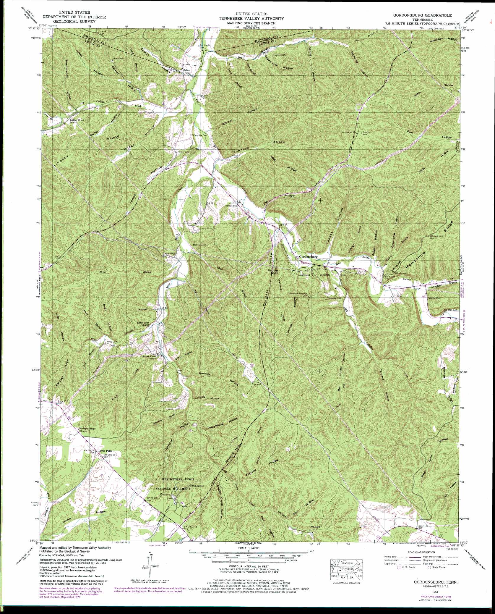
Gordonsburg Topo Map Tennessee
To zoom in, hover over the map of Gordonsburg
USGS Topo Quad 35087e4 - 1:24,000 scale
| Topo Map Name: | Gordonsburg |
| USGS Topo Quad ID: | 35087e4 |
| Print Size: | ca. 21 1/4" wide x 27" high |
| Southeast Coordinates: | 35.5° N latitude / 87.375° W longitude |
| Map Center Coordinates: | 35.5625° N latitude / 87.4375° W longitude |
| U.S. State: | TN |
| Filename: | o35087e4.jpg |
| Download Map JPG Image: | Gordonsburg topo map 1:24,000 scale |
| Map Type: | Topographic |
| Topo Series: | 7.5´ |
| Map Scale: | 1:24,000 |
| Source of Map Images: | United States Geological Survey (USGS) |
| Alternate Map Versions: |
Gordonsburg TN 1936 Download PDF Buy paper map Gordonsburg TN 1951, updated 1957 Download PDF Buy paper map Gordonsburg TN 1951, updated 1979 Download PDF Buy paper map Gordonsburg TN 2010 Download PDF Buy paper map Gordonsburg TN 2013 Download PDF Buy paper map Gordonsburg TN 2016 Download PDF Buy paper map |
1:24,000 Topo Quads surrounding Gordonsburg
Coble |
Whitfield |
Centerville |
Littlelot |
Primm Springs |
Pleasantville |
Beaverdam Springs |
Sunrise |
Greenfield Bend |
Williamsport |
Graves Spring |
Kimmins |
Gordonsburg |
Mount Joy |
Mount Pleasant |
Topsy |
Riverside |
Henryville |
Summertown |
Sandy Hook |
Negro Hollow |
Ovilla |
Deerfield |
Ethridge |
Campbellsville |
> Back to 35087e1 at 1:100,000 scale
> Back to 35086a1 at 1:250,000 scale
> Back to U.S. Topo Maps home
Gordonsburg topo map: Gazetteer
Gordonsburg: Areas
Flat Woods elevation 276m 905′Gordonsburg: Mines
Carrol Bank Prospect elevation 257m 843′Eel Branch Prospect elevation 285m 935′
Hartley Branch Prospect elevation 279m 915′
Low Gap Branch Prospect Number One elevation 268m 879′
Low Gap Branch Prospect Number Two elevation 289m 948′
Lyon Prospect elevation 282m 925′
Natchez Trace Prospect elevation 291m 954′
Stockard Prospect elevation 253m 830′
Wilson Branch - Cade Branch Prospect elevation 288m 944′
Gordonsburg: Parks
Meriwether Lewis National Monument elevation 281m 921′Gordonsburg: Populated Places
Gordonsburg elevation 186m 610′Newburg (historical) elevation 300m 984′
Palestine (historical) elevation 202m 662′
Salem elevation 192m 629′
Springer Ridge (historical) elevation 283m 928′
Gordonsburg: Ridges
Bennett Ridge elevation 270m 885′Lindsey Ridge elevation 228m 748′
Gordonsburg: Springs
Old Spring elevation 243m 797′Gordonsburg: Streams
Anderson Branch elevation 189m 620′Beech Branch elevation 177m 580′
Black Branch elevation 186m 610′
Briar Branch elevation 187m 613′
Brush Creek elevation 195m 639′
Cade Branch elevation 216m 708′
Collier Branch elevation 227m 744′
Dry Branch elevation 175m 574′
Eel Branch elevation 189m 620′
Fall Branch elevation 208m 682′
Georgia Branch elevation 221m 725′
Hartley Branch elevation 206m 675′
Hartley Branch elevation 201m 659′
Hick Hill Branch elevation 195m 639′
Indian Creek elevation 174m 570′
Kittrell Branch elevation 189m 620′
Langford Branch elevation 195m 639′
Little Grinders Creek elevation 189m 620′
Little Swan Creek elevation 177m 580′
Low Gap Branch elevation 177m 580′
Perismmon Branch elevation 180m 590′
Piney Branch elevation 195m 639′
Rocky Branch elevation 189m 620′
Sammies Branch elevation 207m 679′
Suck Branch elevation 177m 580′
Tate Branch elevation 226m 741′
Gordonsburg: Summits
Kittrell Hill elevation 256m 839′Rabbitt Knob elevation 251m 823′
Gordonsburg: Valleys
Auntney Hollow elevation 221m 725′Berry Hollow elevation 194m 636′
Bradford Hollow elevation 222m 728′
Burl Hollow elevation 216m 708′
Collier Hollow elevation 226m 741′
Cubbington Hollow elevation 189m 620′
Cudge Hollow elevation 177m 580′
Dark Hollow elevation 242m 793′
Dedin Hollow elevation 209m 685′
Dyestone Hollow elevation 211m 692′
English Camp Hollow elevation 219m 718′
English Hollow elevation 189m 620′
Fall Hollow elevation 180m 590′
Faucette Hollow elevation 188m 616′
Garrett Hollow elevation 183m 600′
Greenbriar Hollow elevation 198m 649′
Hensley Hollow elevation 205m 672′
Hog Hollow elevation 194m 636′
Jack Hollow elevation 202m 662′
Jagger Hollow elevation 195m 639′
Jerden Hollow elevation 237m 777′
Joby Hollow elevation 216m 708′
Johnson Hollow elevation 179m 587′
Jones Hollow elevation 180m 590′
Limestone Hollow elevation 238m 780′
Line Hollow elevation 213m 698′
Mail Hollow elevation 197m 646′
Mitchell Hollow elevation 183m 600′
Panther Hollow elevation 214m 702′
Peavyhouse Hollow elevation 212m 695′
Plazy Hollow elevation 208m 682′
Quillen Hollow elevation 183m 600′
Silky Hollow elevation 197m 646′
Simmons Hollow elevation 206m 675′
Smoky Hollow elevation 197m 646′
Spring Hollow elevation 196m 643′
Sugarcamp Hollow elevation 183m 600′
Sweet Hollow elevation 195m 639′
Tanyard Hollow elevation 202m 662′
Tate Hollow elevation 231m 757′
Touchmenot Hollow elevation 193m 633′
Wade Hollow elevation 223m 731′
Wiss Hollow elevation 189m 620′
Yankee Hollow elevation 188m 616′
Gordonsburg digital topo map on disk
Buy this Gordonsburg topo map showing relief, roads, GPS coordinates and other geographical features, as a high-resolution digital map file on DVD: