Blytheville Topo Map Arkansas
To zoom in, hover over the map of Blytheville
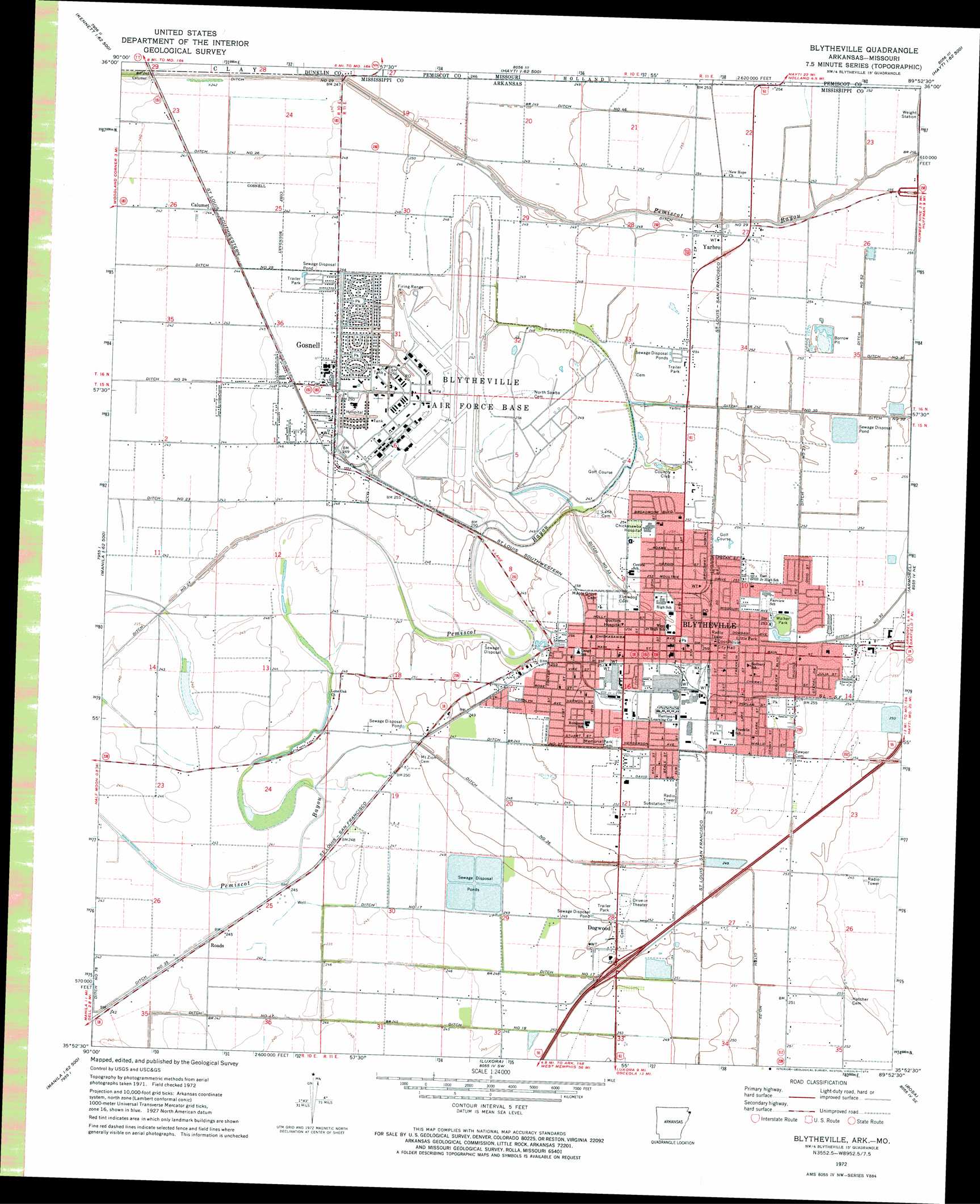
USGS Topo Quad 35089h8 - 1:24,000 scale
| Topo Map Name: | Blytheville |
| USGS Topo Quad ID: | 35089h8 |
| Print Size: | ca. 21 1/4" wide x 27" high |
| Southeast Coordinates: | 35.875° N latitude / 89.875° W longitude |
| Map Center Coordinates: | 35.9375° N latitude / 89.9375° W longitude |
| U.S. States: | AR, MO |
| Filename: | o35089h8.jpg |
| Download Map JPG Image: | Blytheville topo map 1:24,000 scale |
| Map Type: | Topographic |
| Topo Series: | 7.5´ |
| Map Scale: | 1:24,000 |
| Source of Map Images: | United States Geological Survey (USGS) |
| Alternate Map Versions: |
Blytheville AR 1972, updated 1974 Download PDF Buy paper map Blytheville AR 1972, updated 1974 Download PDF Buy paper map Blytheville AR 2011 Download PDF Buy paper map Blytheville AR 2014 Download PDF Buy paper map |
1:24,000 Topo Quads surrounding Blytheville
Senath |
Kennett South |
Deering |
Hayti Heights |
Caruthersville |
Arbyrd |
Hornersville |
Denton |
Steele |
Cottonwood Point |
Manila North |
Half Moon |
Blytheville |
Armorel |
Chic |
Manila South |
Dell |
Luxora |
Rosa |
Open Lake |
Etowah |
Keiser |
Osceola |
Golddust |
Fort Pillow |
> Back to 35089e1 at 1:100,000 scale
> Back to 35088a1 at 1:250,000 scale
> Back to U.S. Topo Maps home
Blytheville topo map: Gazetteer
Blytheville: Airports
Mississippi County Hospital Heliport elevation 78m 255′Randal Field elevation 72m 236′
Blytheville: Canals
Ditch Number 17 elevation 72m 236′Ditch Number 18 elevation 73m 239′
Ditch Number 22 elevation 76m 249′
Ditch Number 27 elevation 74m 242′
Ditch Number 29 elevation 73m 239′
Ditch Number 30 elevation 77m 252′
Ditch Number 31 elevation 77m 252′
Ditch Number 33 elevation 77m 252′
Ditch Number 35 elevation 73m 239′
Ditch Number 36 elevation 75m 246′
Ditch Number 37 elevation 76m 249′
Ditch Number 46 elevation 75m 246′
Ditch Number 52 elevation 76m 249′
Blytheville: Crossings
Interchange 63 elevation 84m 275′Blytheville: Parks
Cypress Park elevation 76m 249′Little Park elevation 78m 255′
Mahoney Park elevation 79m 259′
Walker Park elevation 79m 259′
Blytheville: Populated Places
Blytheville elevation 78m 255′Calumet elevation 74m 242′
Chickasawba elevation 80m 262′
Dogwood elevation 77m 252′
Gosnell elevation 76m 249′
North Sabie (historical) elevation 78m 255′
Paepcke (historical) elevation 73m 239′
Yarbro elevation 76m 249′
Blytheville: Post Offices
Blytheville Post Office elevation 79m 259′Blytheville: Ridges
Dogwood Ridge elevation 76m 249′Blytheville: Summits
Chickasawba Mound elevation 79m 259′Blytheville digital topo map on disk
Buy this Blytheville topo map showing relief, roads, GPS coordinates and other geographical features, as a high-resolution digital map file on DVD: