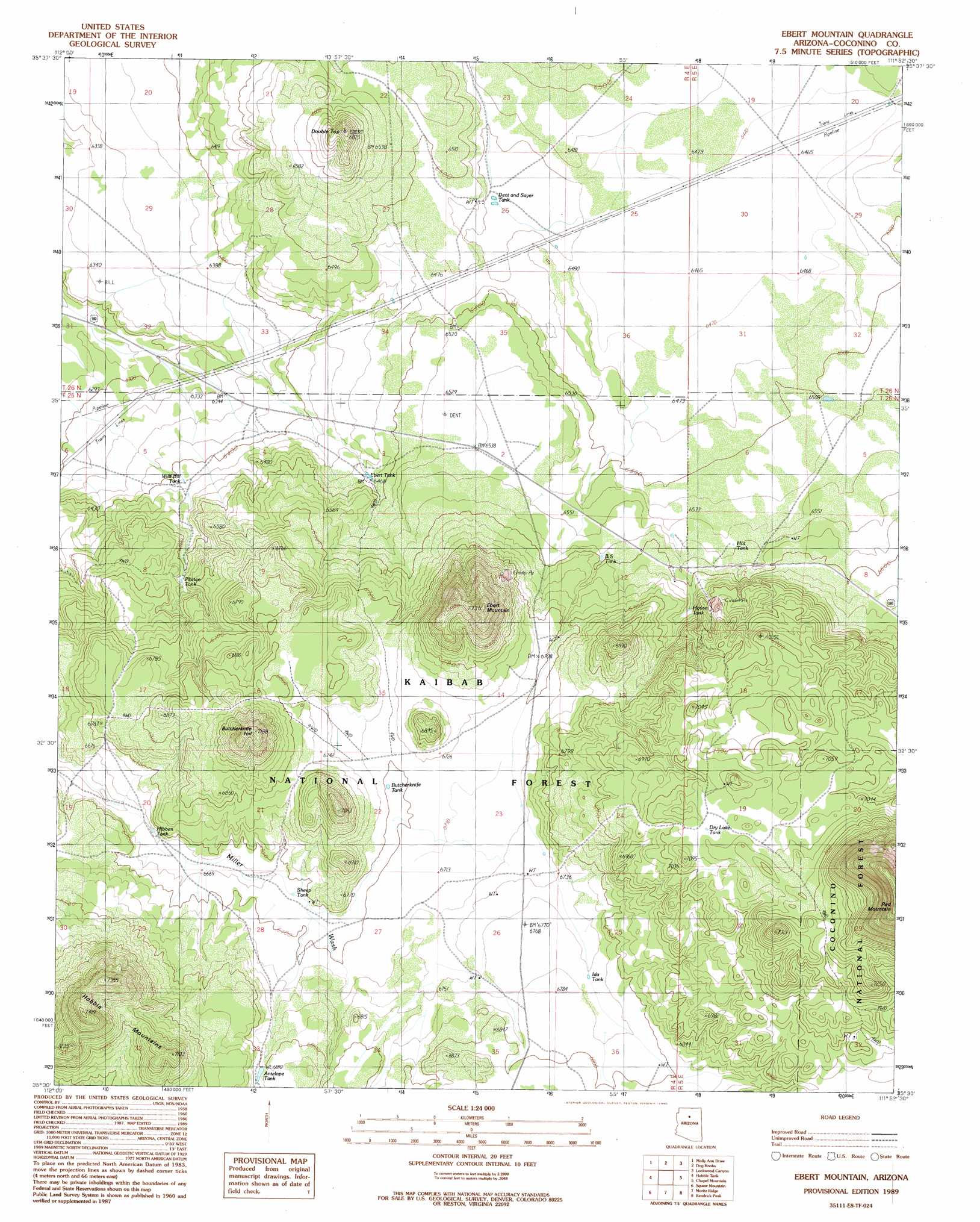
Ebert Mountain Topo Map Arizona
To zoom in, hover over the map of Ebert Mountain
USGS Topo Quad 35111e8 - 1:24,000 scale
| Topo Map Name: | Ebert Mountain |
| USGS Topo Quad ID: | 35111e8 |
| Print Size: | ca. 21 1/4" wide x 27" high |
| Southeast Coordinates: | 35.5° N latitude / 111.875° W longitude |
| Map Center Coordinates: | 35.5625° N latitude / 111.9375° W longitude |
| U.S. State: | AZ |
| Filename: | o35111e8.jpg |
| Download Map JPG Image: | Ebert Mountain topo map 1:24,000 scale |
| Map Type: | Topographic |
| Topo Series: | 7.5´ |
| Map Scale: | 1:24,000 |
| Source of Map Images: | United States Geological Survey (USGS) |
| Alternate Map Versions: |
Ebert Mountain AZ 1989, updated 1990 Download PDF Buy paper map Ebert Mountain AZ 2012 Download PDF Buy paper map Ebert Mountain AZ 2014 Download PDF Buy paper map |
| FStopo: | US Forest Service topo Ebert Mountain is available: Download FStopo PDF Download FStopo TIF |
1:24,000 Topo Quads surrounding Ebert Mountain
Red Butte Sw |
Red Butte |
Harbison Tank |
Peterson Flat |
Willows Camp |
Valle Tank |
Molly Ann Draw |
Dog Knobs |
Lockwood Canyon |
Additional Hill |
Howard Lake |
Hobble Tank |
Ebert Mountain |
Chapel Mountain |
S P Mountain |
Howard Mesa |
Squaw Mountain |
Moritz Ridge |
Kendrick Peak |
White Horse Hills |
Williams North |
Sitgreaves Mountain |
Parks |
Wing Mountain |
Humphreys Peak |
> Back to 35111e1 at 1:100,000 scale
> Back to 35110a1 at 1:250,000 scale
> Back to U.S. Topo Maps home
Ebert Mountain topo map: Gazetteer
Ebert Mountain: Reservoirs
Antelope Tank elevation 2077m 6814′Arizona Game and Fish TrickTank elevation 2131m 6991′
BS Tank elevation 2012m 6601′
Butcherknife Tank elevation 2043m 6702′
Cinder Pit Tank elevation 1999m 6558′
Dent and Sayer Tank elevation 1974m 6476′
Dog Knobs Trick Tank elevation 2146m 7040′
Dry Lake Tank elevation 2144m 7034′
Ebert Guzzler elevation 2063m 6768′
Ebert Tank elevation 1974m 6476′
Everett Guzzler elevation 1987m 6519′
Ford Tank elevation 1984m 6509′
Hibben Tank elevation 2031m 6663′
Hot Tank elevation 1999m 6558′
House Tank elevation 2021m 6630′
Ida Tank elevation 2065m 6774′
Pinyon Tank elevation 2006m 6581′
Platten Tank elevation 1989m 6525′
Sheep Tank elevation 2041m 6696′
Webster Tank elevation 2055m 6742′
Wild Bill Tank elevation 1955m 6414′
Ebert Mountain: Summits
Butcherknife Hill elevation 2186m 7171′Double Top elevation 2078m 6817′
Ebert Mountain elevation 2229m 7312′
Red Mountain elevation 2421m 7942′
Ebert Mountain digital topo map on disk
Buy this Ebert Mountain topo map showing relief, roads, GPS coordinates and other geographical features, as a high-resolution digital map file on DVD: