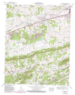
New Market Topo Map Tennessee
To zoom in, hover over the map of New Market
USGS Topo Quad 36083a5 - 1:24,000 scale
| Topo Map Name: | New Market |
| USGS Topo Quad ID: | 36083a5 |
| Print Size: | ca. 21 1/4" wide x 27" high |
| Southeast Coordinates: | 36° N latitude / 83.5° W longitude |
| Map Center Coordinates: | 36.0625° N latitude / 83.5625° W longitude |
| U.S. State: | TN |
| Filename: | o36083a5.jpg |
| Download Map JPG Image: | New Market topo map 1:24,000 scale |
| Map Type: | Topographic |
| Topo Series: | 7.5´ |
| Map Scale: | 1:24,000 |
| Source of Map Images: | United States Geological Survey (USGS) |
| Alternate Map Versions: |
New Market TN 1935 Download PDF Buy paper map New Market TN 1939, updated 1956 Download PDF Buy paper map New Market TN 1940 Download PDF Buy paper map New Market TN 1940 Download PDF Buy paper map New Market TN 1961, updated 1963 Download PDF Buy paper map New Market TN 1961, updated 1980 Download PDF Buy paper map New Market TN 1961, updated 1987 Download PDF Buy paper map New Market TN 2010 Download PDF Buy paper map New Market TN 2013 Download PDF Buy paper map New Market TN 2016 Download PDF Buy paper map |
1:24,000 Topo Quads surrounding New Market
> Back to 36083a1 at 1:100,000 scale
> Back to 36082a1 at 1:250,000 scale
> Back to U.S. Topo Maps home
New Market topo map: Gazetteer
New Market: Crossings
Interchange 412 elevation 281m 921′New Market: Dams
Rucker Dam elevation 323m 1059′New Market: Gaps
Rocky Gap elevation 428m 1404′Russell Gap elevation 414m 1358′
New Market: Lakes
Ault Lake elevation 302m 990′New Market: Mines
Grasselli Mine elevation 337m 1105′North Friends Station Mine elevation 307m 1007′
Young Mine elevation 306m 1003′
New Market: Populated Places
Alena (historical) elevation 372m 1220′Deer Ridge Mobile Home Court elevation 360m 1181′
Dumplin elevation 300m 984′
Four Points elevation 329m 1079′
Friends Station elevation 302m 990′
Laconte View Mobile Home Park elevation 354m 1161′
Lockmere Estates elevation 333m 1092′
Lucilla (historical) elevation 311m 1020′
Nances Grove elevation 335m 1099′
New Market elevation 327m 1072′
Piedmont elevation 318m 1043′
Rocky Valley elevation 331m 1085′
Woolardtown elevation 341m 1118′
New Market: Post Offices
New Market Post Office elevation 308m 1010′New Market: Reservoirs
Rucker Lake elevation 323m 1059′New Market: Springs
Caldwell Spring elevation 360m 1181′Dumplin Spring elevation 289m 948′
McCampbell Spring elevation 346m 1135′
Witt Spring elevation 379m 1243′
New Market: Streams
Blue Spring Branch elevation 288m 944′Buttermilk Branch elevation 289m 948′
Caldwell Branch elevation 309m 1013′
Dance Branch elevation 311m 1020′
Dry Land Creek elevation 292m 958′
Lewis Branch elevation 286m 938′
Little Tuckahoe Creek elevation 312m 1023′
Lost Creek elevation 286m 938′
Piedmont Branch elevation 300m 984′
New Market: Summits
Batten Knob elevation 380m 1246′Sourwood Mountain elevation 431m 1414′
Thomas Knob elevation 414m 1358′
New Market: Valleys
Newman Hollow elevation 304m 997′New Market digital topo map on disk
Buy this New Market topo map showing relief, roads, GPS coordinates and other geographical features, as a high-resolution digital map file on DVD:
Western Virginia & Southern West Virginia
Buy digital topo maps: Western Virginia & Southern West Virginia


