General Grant Grove Topo Map California
To zoom in, hover over the map of General Grant Grove
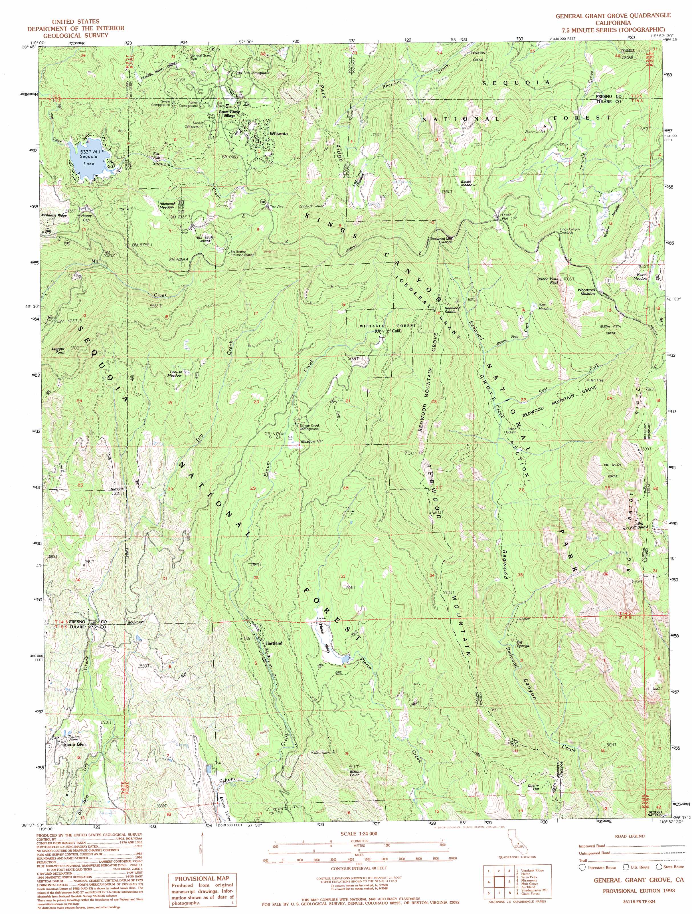
USGS Topo Quad 36118f8 - 1:24,000 scale
| Topo Map Name: | General Grant Grove |
| USGS Topo Quad ID: | 36118f8 |
| Print Size: | ca. 21 1/4" wide x 27" high |
| Southeast Coordinates: | 36.625° N latitude / 118.875° W longitude |
| Map Center Coordinates: | 36.6875° N latitude / 118.9375° W longitude |
| U.S. State: | CA |
| Filename: | o36118f8.jpg |
| Download Map JPG Image: | General Grant Grove topo map 1:24,000 scale |
| Map Type: | Topographic |
| Topo Series: | 7.5´ |
| Map Scale: | 1:24,000 |
| Source of Map Images: | United States Geological Survey (USGS) |
| Alternate Map Versions: |
General Grant Grove CA 1987, updated 1987 Download PDF Buy paper map General Grant Grove CA 1993, updated 1995 Download PDF Buy paper map General Grant Grove CA 2012 Download PDF Buy paper map General Grant Grove CA 2015 Download PDF Buy paper map |
| FStopo: | US Forest Service topo General Grant Grove is available: Download FStopo PDF Download FStopo TIF |
1:24,000 Topo Quads surrounding General Grant Grove
Sacate Ridge |
Patterson Mountain |
Rough Spur |
Tehipite Dome |
Slide Bluffs |
Luckett Mountain |
Verplank Ridge |
Hume |
Wren Peak |
Cedar Grove |
Tucker Mountain |
Miramonte |
General Grant Grove |
Muir Grove |
Mount Stillman |
Stokes Mountain |
Auckland |
Shadequarter Mountain |
Giant Forest |
Lodgepole |
Ivanhoe |
Woodlake |
Kaweah |
Case Mountain |
Silver City |
> Back to 36118e1 at 1:100,000 scale
> Back to 36118a1 at 1:250,000 scale
> Back to U.S. Topo Maps home
General Grant Grove topo map: Gazetteer
General Grant Grove: Dams
Sequoia Lake 693 Dam elevation 1635m 5364′General Grant Grove: Falls
Ella Falls elevation 1728m 5669′General Grant Grove: Flats
Bacon Meadow elevation 2192m 7191′Cherry Flat elevation 1355m 4445′
Fox Flat elevation 2151m 7057′
Grouse Meadow elevation 1473m 4832′
Hart Meadow elevation 1968m 6456′
Hitchcock Meadow elevation 1869m 6131′
Log Corral Meadow elevation 2218m 7276′
Meadow Flat elevation 1459m 4786′
Pierce Valley elevation 1419m 4655′
Quail Flat elevation 2109m 6919′
Rabbit Meadow elevation 2361m 7746′
Weston Meadow elevation 2069m 6788′
Woodcock Meadow elevation 2192m 7191′
General Grant Grove: Forests
Whitaker Forest elevation 1646m 5400′General Grant Grove: Gaps
Happy Gap elevation 1712m 5616′Redwood Saddle elevation 1901m 6236′
General Grant Grove: Lakes
Sequoia Lake elevation 1628m 5341′General Grant Grove: Parks
General Grant Grove Section Kings Canyon Nat elevation 1790m 5872′General Grant Grove: Populated Places
Grant Grove Village elevation 2012m 6601′Hartland elevation 1341m 4399′
Wilsonia elevation 2022m 6633′
General Grant Grove: Ridges
Big Baldy Ridge elevation 2333m 7654′Redwood Mountain elevation 1856m 6089′
General Grant Grove: Springs
Big Springs elevation 1546m 5072′General Grant Grove: Streams
Buena Vista Creek elevation 1711m 5613′Sequoia Creek elevation 1628m 5341′
General Grant Grove: Summits
Big Baldy elevation 2449m 8034′Eshom Point elevation 1551m 5088′
Logger Point elevation 1733m 5685′
General Grant Grove: Valleys
Redwood Canyon elevation 1341m 4399′General Grant Grove: Woods
Bearskin Grove elevation 1932m 6338′Big Baldy Grove elevation 2154m 7066′
Big Stump Grove elevation 1855m 6085′
Buena Vista Grove elevation 2131m 6991′
General Grant Grove elevation 1902m 6240′
Redwood Mountain Grove elevation 1964m 6443′
Tenmile Grove elevation 1999m 6558′
General Grant Grove digital topo map on disk
Buy this General Grant Grove topo map showing relief, roads, GPS coordinates and other geographical features, as a high-resolution digital map file on DVD:
Southern Sierra Nevada, California & Southern Nevada
Buy digital topo maps: Southern Sierra Nevada, California & Southern Nevada