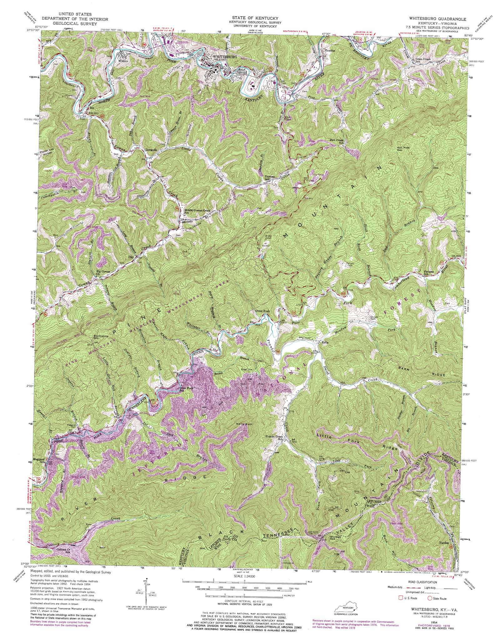
Whitesburg Topo Map Kentucky
To zoom in, hover over the map of Whitesburg
USGS Topo Quad 37082a7 - 1:24,000 scale
| Topo Map Name: | Whitesburg |
| USGS Topo Quad ID: | 37082a7 |
| Print Size: | ca. 21 1/4" wide x 27" high |
| Southeast Coordinates: | 37° N latitude / 82.75° W longitude |
| Map Center Coordinates: | 37.0625° N latitude / 82.8125° W longitude |
| U.S. States: | KY, VA |
| Filename: | o37082a7.jpg |
| Download Map JPG Image: | Whitesburg topo map 1:24,000 scale |
| Map Type: | Topographic |
| Topo Series: | 7.5´ |
| Map Scale: | 1:24,000 |
| Source of Map Images: | United States Geological Survey (USGS) |
| Alternate Map Versions: |
Pardee KY 1935 Download PDF Buy paper map Whitesburg KY 1954, updated 1956 Download PDF Buy paper map Whitesburg KY 1954, updated 1964 Download PDF Buy paper map Whitesburg KY 1954, updated 1976 Download PDF Buy paper map Whitesburg KY 1954, updated 1978 Download PDF Buy paper map Whitesburg KY 2011 Download PDF Buy paper map Whitesburg KY 2013 Download PDF Buy paper map Whitesburg KY 2016 Download PDF Buy paper map |
| FStopo: | US Forest Service topo Whitesburg is available: Download FStopo PDF Download FStopo TIF |
1:24,000 Topo Quads surrounding Whitesburg
Carrie |
Hindman |
Kite |
Wheelwright |
Dorton |
Vicco |
Blackey |
Mayking |
Jenkins West |
Jenkins East |
Tilford |
Roxana |
Whitesburg |
Flat Gap |
Pound |
Louellen |
Benham |
Appalachia |
Norton |
Wise |
Pennington Gap |
Keokee |
Big Stone Gap |
East Stone Gap |
Fort Blackmore |
> Back to 37082a1 at 1:100,000 scale
> Back to 37082a1 at 1:250,000 scale
> Back to U.S. Topo Maps home
Whitesburg topo map: Gazetteer
Whitesburg: Airports
Appalachian Regional Hospital Heliport elevation 377m 1236′Pine Mountain Aero Heliport elevation 390m 1279′
Whitesburg: Gaps
Ran Polly Gap elevation 807m 2647′Scuttlehole Gap elevation 768m 2519′
Stonega Gap elevation 1033m 3389′
Whitesburg: Lakes
Elk Pond elevation 1098m 3602′Whitesburg: Parks
Hensley-Pine Mountain Wildlife Management Area elevation 787m 2582′Whitesburg: Populated Places
Big Cowan elevation 412m 1351′Crafts Colly elevation 354m 1161′
Day elevation 394m 1292′
Dongola elevation 350m 1148′
Eolia elevation 517m 1696′
Ermine elevation 378m 1240′
Ice elevation 347m 1138′
Oven Fork elevation 497m 1630′
Pardee elevation 656m 2152′
West Whitesburg elevation 360m 1181′
Whitco elevation 347m 1138′
Whitesburg elevation 357m 1171′
Whitesburg: Post Offices
Colly Post Office (historical) elevation 360m 1181′Day Post Office (historical) elevation 393m 1289′
Dongola Post Office (historical) elevation 344m 1128′
Eolia Post Office elevation 513m 1683′
Ermine Post Office elevation 368m 1207′
Ice Post Office (historical) elevation 344m 1128′
Maggard Post Office (historical) elevation 474m 1555′
Mandrake Post Office (historical) elevation 401m 1315′
Oven Fork Post Office (historical) elevation 500m 1640′
Pardridhe Post Office (historical) elevation 485m 1591′
Whitco Post Office (historical) elevation 341m 1118′
Whitco Post Office (historical) elevation 343m 1125′
Whitesburg: Ridges
Barn Ridge elevation 755m 2477′Little Fork Ridge elevation 881m 2890′
River Ridge elevation 896m 2939′
Whitesburg: Streams
Bad Branch elevation 532m 1745′Bartesta Branch elevation 364m 1194′
Bee Branch elevation 598m 1961′
Brown Branch elevation 489m 1604′
Brown Branch elevation 336m 1102′
Bunker Branch elevation 583m 1912′
Cowan Branch elevation 355m 1164′
Cowan Creek elevation 336m 1102′
Crafts Colly Creek elevation 355m 1164′
Craiger Branch elevation 482m 1581′
Day Branch elevation 343m 1125′
Franks Creek elevation 492m 1614′
Grapevine Branch elevation 349m 1145′
Hammonds Branch elevation 351m 1151′
Hampton Branch elevation 338m 1108′
Hayes Branch elevation 478m 1568′
Henry Maggard Branch elevation 492m 1614′
Horseshoe Branch elevation 486m 1594′
Jenkins Branch elevation 479m 1571′
Joe Day Branch elevation 482m 1581′
Johnson House Branch elevation 348m 1141′
Little Cowan Creek elevation 346m 1135′
Little Fork elevation 560m 1837′
Little Joe Day Branch elevation 481m 1578′
Long Branch elevation 391m 1282′
Maggard Branch elevation 476m 1561′
Meadow Branch elevation 539m 1768′
Meadow Fork elevation 510m 1673′
Mussel White Branch elevation 490m 1607′
Ovenfork Branch elevation 400m 1312′
Pert Creek elevation 352m 1154′
Presley House Branch elevation 510m 1673′
Roberts Branch elevation 485m 1591′
Sandlick Creek elevation 342m 1122′
Shop Branch elevation 361m 1184′
Slick Rock Branch elevation 525m 1722′
Slipfield Branch elevation 394m 1292′
Smith Creek elevation 513m 1683′
Solomon Branch elevation 349m 1145′
South Fork Collier Creek elevation 516m 1692′
Sturgill Branch elevation 414m 1358′
Sumpter Branch elevation 414m 1358′
Trace Fork elevation 602m 1975′
Whitaker Branch elevation 488m 1601′
Whitesburg: Summits
Halls Butt elevation 944m 3097′High Rock elevation 837m 2746′
Whitesburg digital topo map on disk
Buy this Whitesburg topo map showing relief, roads, GPS coordinates and other geographical features, as a high-resolution digital map file on DVD:
Western Virginia & Southern West Virginia
Buy digital topo maps: Western Virginia & Southern West Virginia