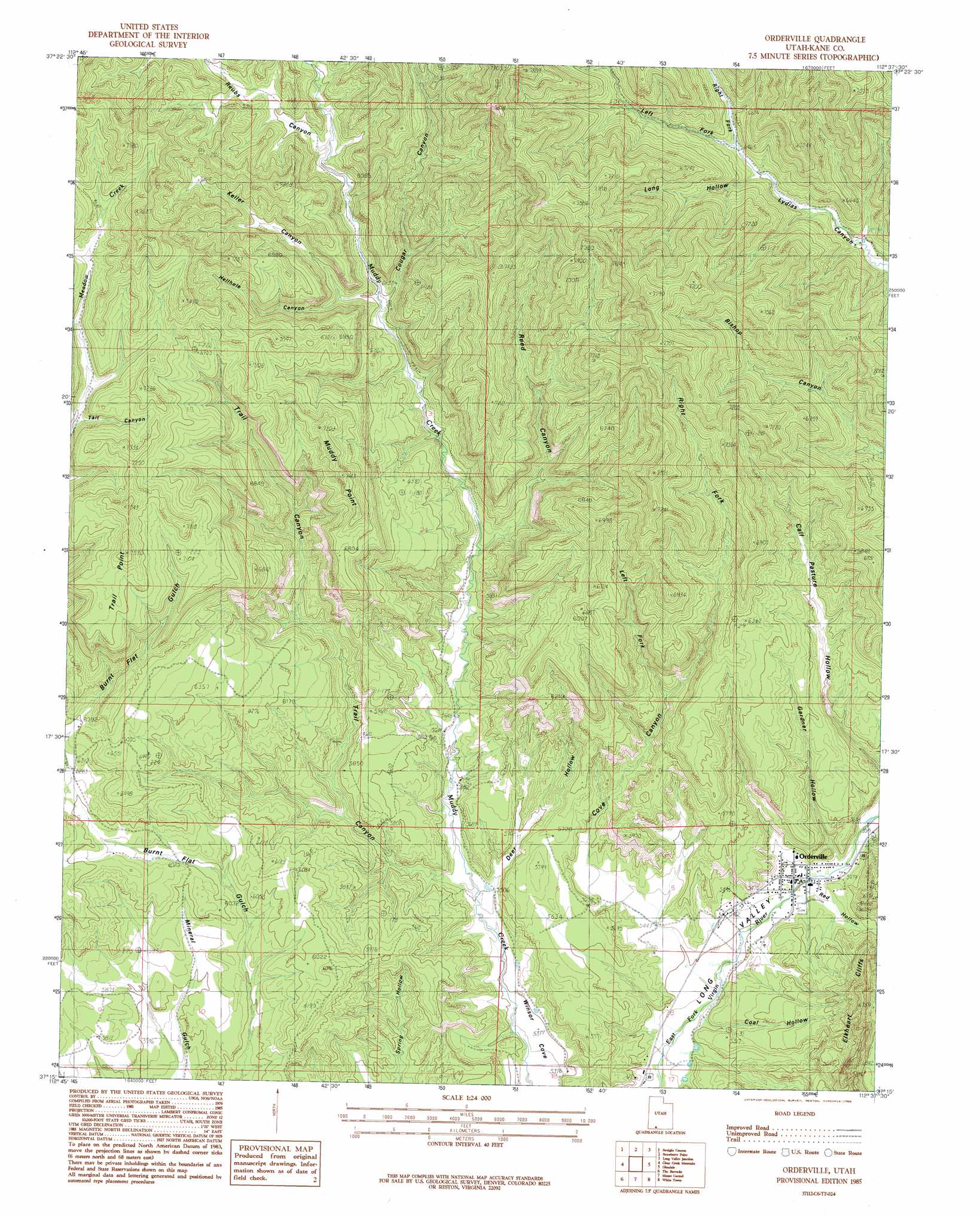
Orderville Topo Map Utah
To zoom in, hover over the map of Orderville
USGS Topo Quad 37112c6 - 1:24,000 scale
| Topo Map Name: | Orderville |
| USGS Topo Quad ID: | 37112c6 |
| Print Size: | ca. 21 1/4" wide x 27" high |
| Southeast Coordinates: | 37.25° N latitude / 112.625° W longitude |
| Map Center Coordinates: | 37.3125° N latitude / 112.6875° W longitude |
| U.S. State: | UT |
| Filename: | o37112c6.jpg |
| Download Map JPG Image: | Orderville topo map 1:24,000 scale |
| Map Type: | Topographic |
| Topo Series: | 7.5´ |
| Map Scale: | 1:24,000 |
| Source of Map Images: | United States Geological Survey (USGS) |
| Alternate Map Versions: |
Orderville UT 1985, updated 1985 Download PDF Buy paper map Orderville UT 2010 Download PDF Buy paper map Orderville UT 2014 Download PDF Buy paper map |
1:24,000 Topo Quads surrounding Orderville
Webster Flat |
Navajo Lake |
Henrie Knolls |
Asay Bench |
George Mountain |
Cogswell Point |
Straight Canyon |
Strawberry Point |
Long Valley Junction |
Alton |
Temple Of Sinawava |
Clear Creek Mountain |
Orderville |
Glendale |
Bald Knoll |
Springdale East |
The Barracks |
Mount Carmel |
White Tower |
Cutler Point |
Hildale |
Elephant Butte |
Yellowjacket Canyon |
Kanab |
Thompson Point |
> Back to 37112a1 at 1:100,000 scale
> Back to 37112a1 at 1:250,000 scale
> Back to U.S. Topo Maps home
Orderville topo map: Gazetteer
Orderville: Airports
Carmel Mountain Ranch Airport elevation 1809m 5935′Orderville: Capes
Muddy Point elevation 2181m 7155′Trail Point elevation 2298m 7539′
Orderville: Populated Places
Orderville elevation 1661m 5449′Orderville: Post Offices
Orderville Post Office elevation 1663m 5456′Orderville: Valleys
Coal Hollow elevation 1632m 5354′Cougar Canyon elevation 1890m 6200′
Cove Canyon elevation 1646m 5400′
Deer Hollow elevation 1682m 5518′
Gardner Hollow elevation 1667m 5469′
Hellhole Canyon elevation 1917m 6289′
Keller Canyon elevation 1927m 6322′
Left Fork Cove Canyon elevation 1784m 5853′
Left Fork Lydias Canyon elevation 1967m 6453′
Long Hollow elevation 1956m 6417′
Red Hollow elevation 1681m 5515′
Reed Canyon elevation 1784m 5853′
Reubs Canyon elevation 1966m 6450′
Right Fork Cove Canyon elevation 1776m 5826′
Right Fork Lydias Canyon elevation 1968m 6456′
Tait Canyon elevation 2084m 6837′
Trail Canyon elevation 1673m 5488′
Winsor Cove elevation 1623m 5324′
Orderville digital topo map on disk
Buy this Orderville topo map showing relief, roads, GPS coordinates and other geographical features, as a high-resolution digital map file on DVD: