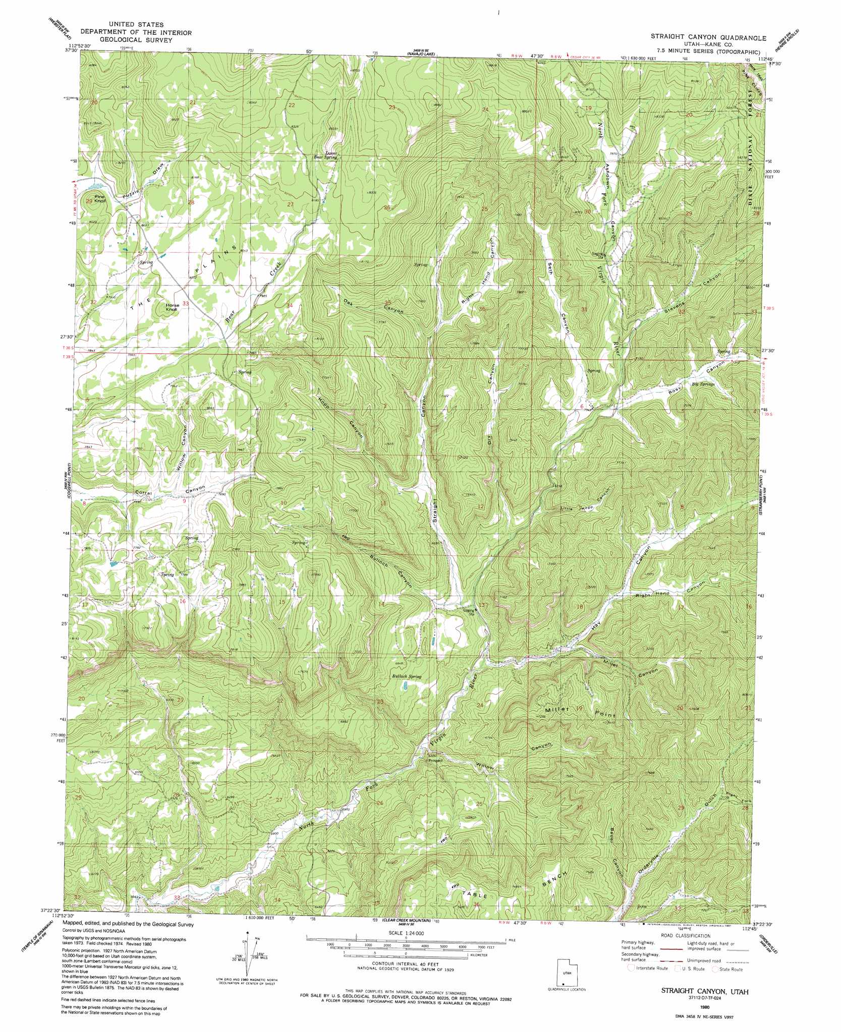
Straight Canyon Topo Map Utah
To zoom in, hover over the map of Straight Canyon
USGS Topo Quad 37112d7 - 1:24,000 scale
| Topo Map Name: | Straight Canyon |
| USGS Topo Quad ID: | 37112d7 |
| Print Size: | ca. 21 1/4" wide x 27" high |
| Southeast Coordinates: | 37.375° N latitude / 112.75° W longitude |
| Map Center Coordinates: | 37.4375° N latitude / 112.8125° W longitude |
| U.S. State: | UT |
| Filename: | o37112d7.jpg |
| Download Map JPG Image: | Straight Canyon topo map 1:24,000 scale |
| Map Type: | Topographic |
| Topo Series: | 7.5´ |
| Map Scale: | 1:24,000 |
| Source of Map Images: | United States Geological Survey (USGS) |
| Alternate Map Versions: |
Orderville Canyon NE UT 1957, updated 1959 Download PDF Buy paper map Orderville Canyon NE UT 1957, updated 1959 Download PDF Buy paper map Straight Canyon UT 1980, updated 1980 Download PDF Buy paper map Straight Canyon UT 1980, updated 1991 Download PDF Buy paper map Straight Canyon UT 2002, updated 2005 Download PDF Buy paper map Straight Canyon UT 2011 Download PDF Buy paper map Straight Canyon UT 2014 Download PDF Buy paper map |
| FStopo: | US Forest Service topo Straight Canyon is available: Download FStopo PDF Download FStopo TIF |
1:24,000 Topo Quads surrounding Straight Canyon
Cedar City |
Flanigan Arch |
Brian Head |
Panguitch Lake |
Haycock Mountain |
Cedar Mountain |
Webster Flat |
Navajo Lake |
Henrie Knolls |
Asay Bench |
Kolob Reservoir |
Cogswell Point |
Straight Canyon |
Strawberry Point |
Long Valley Junction |
The Guardian Angels |
Temple Of Sinawava |
Clear Creek Mountain |
Orderville |
Glendale |
Springdale West |
Springdale East |
The Barracks |
Mount Carmel |
White Tower |
> Back to 37112a1 at 1:100,000 scale
> Back to 37112a1 at 1:250,000 scale
> Back to U.S. Topo Maps home
Straight Canyon topo map: Gazetteer
Straight Canyon: Cliffs
Millet Point elevation 2189m 7181′Straight Canyon: Plains
The Plains elevation 2446m 8024′Straight Canyon: Springs
Big Springs elevation 2211m 7253′Bulloch Spring elevation 2073m 6801′
Lower Bear Spring elevation 2511m 8238′
Upper Bear Spring elevation 2614m 8576′
Straight Canyon: Summits
Horse Knoll elevation 2462m 8077′Straight Canyon: Valleys
Ashdown Canyon elevation 2326m 7631′Bauer Canyon elevation 2118m 6948′
Bulloch Canyon elevation 2003m 6571′
Dry Canyon elevation 2046m 6712′
Hay Canyon elevation 1936m 6351′
Hopp Canyon elevation 2078m 6817′
Little Hopp Canyon elevation 2040m 6692′
Millet Canyon elevation 1988m 6522′
Oak Canyon elevation 2145m 7037′
Right Fork Orderville Gulch elevation 2241m 7352′
Right Hand Canyon elevation 2147m 7043′
Right Hand Canyon elevation 2043m 6702′
Rosy Canyon elevation 2143m 7030′
Seth Canyon elevation 2146m 7040′
Stevens Canyon elevation 2194m 7198′
Straight Canyon elevation 2008m 6587′
Willow Canyon elevation 1885m 6184′
Willow Canyon elevation 2324m 7624′
Straight Canyon digital topo map on disk
Buy this Straight Canyon topo map showing relief, roads, GPS coordinates and other geographical features, as a high-resolution digital map file on DVD: