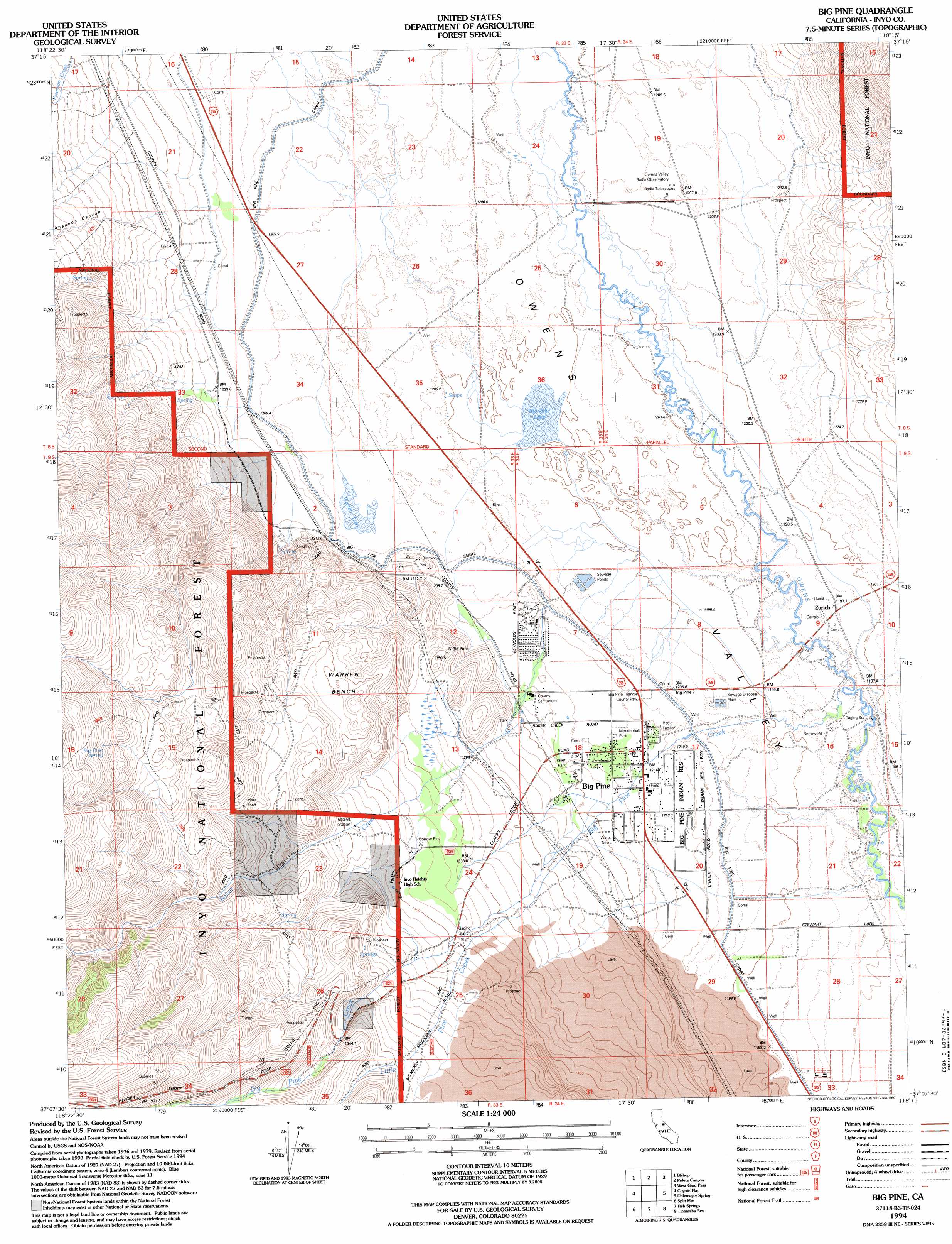
Big Pine Topo Map California
To zoom in, hover over the map of Big Pine
USGS Topo Quad 37118b3 - 1:24,000 scale
| Topo Map Name: | Big Pine |
| USGS Topo Quad ID: | 37118b3 |
| Print Size: | ca. 21 1/4" wide x 27" high |
| Southeast Coordinates: | 37.125° N latitude / 118.25° W longitude |
| Map Center Coordinates: | 37.1875° N latitude / 118.3125° W longitude |
| U.S. State: | CA |
| Filename: | o37118b3.jpg |
| Download Map JPG Image: | Big Pine topo map 1:24,000 scale |
| Map Type: | Topographic |
| Topo Series: | 7.5´ |
| Map Scale: | 1:24,000 |
| Source of Map Images: | United States Geological Survey (USGS) |
| Alternate Map Versions: |
Big Pine CA 1984, updated 1984 Download PDF Buy paper map Big Pine CA 1984, updated 1994 Download PDF Buy paper map Big Pine CA 1994, updated 1997 Download PDF Buy paper map Big Pine CA 2012 Download PDF Buy paper map Big Pine CA 2015 Download PDF Buy paper map |
| FStopo: | US Forest Service topo Big Pine is available: Download FStopo PDF Download FStopo TIF |
1:24,000 Topo Quads surrounding Big Pine
Rovana |
Fish Slough |
Laws |
Blanco Mountain |
Crooked Creek |
Tungsten Hills |
Bishop |
Poleta Canyon |
Westgard Pass |
Deep Springs Lake |
Mount Thompson |
Coyote Flat |
Big Pine |
Uhlmeyer Spring |
Cowhorn Valley |
North Palisade |
Split Mountain |
Fish Springs |
Tinemaha Reservoir |
Waucoba Mountain |
Marion Peak |
Mount Pinchot |
Aberdeen |
Blackrock |
Mazourka Peak |
> Back to 37118a1 at 1:100,000 scale
> Back to 37118a1 at 1:250,000 scale
> Back to U.S. Topo Maps home
Big Pine topo map: Gazetteer
Big Pine: Benches
Rolling Green Terrace elevation 1216m 3989′Warren Bench elevation 1511m 4957′
Big Pine: Canals
Big Pine Canal elevation 1207m 3959′Big Pine: Lakes
Klondike Lake elevation 1201m 3940′Warren Lake elevation 1207m 3959′
Big Pine: Mines
Bakoch Prospect elevation 2064m 6771′Sierra White Quarry elevation 1575m 5167′
Big Pine: Parks
Big Pine Triangle County Park elevation 1206m 3956′Mendenhall Park elevation 1214m 3982′
Big Pine: Populated Places
Big Pine elevation 1216m 3989′Zurich elevation 1199m 3933′
Big Pine: Springs
Big Pine Spring elevation 2014m 6607′Big Pine: Streams
Baker Creek elevation 1206m 3956′Big Pine Creek elevation 1193m 3914′
Little Pine Creek elevation 1404m 4606′
Big Pine: Valleys
Shannon Canyon elevation 1216m 3989′Big Pine digital topo map on disk
Buy this Big Pine topo map showing relief, roads, GPS coordinates and other geographical features, as a high-resolution digital map file on DVD: