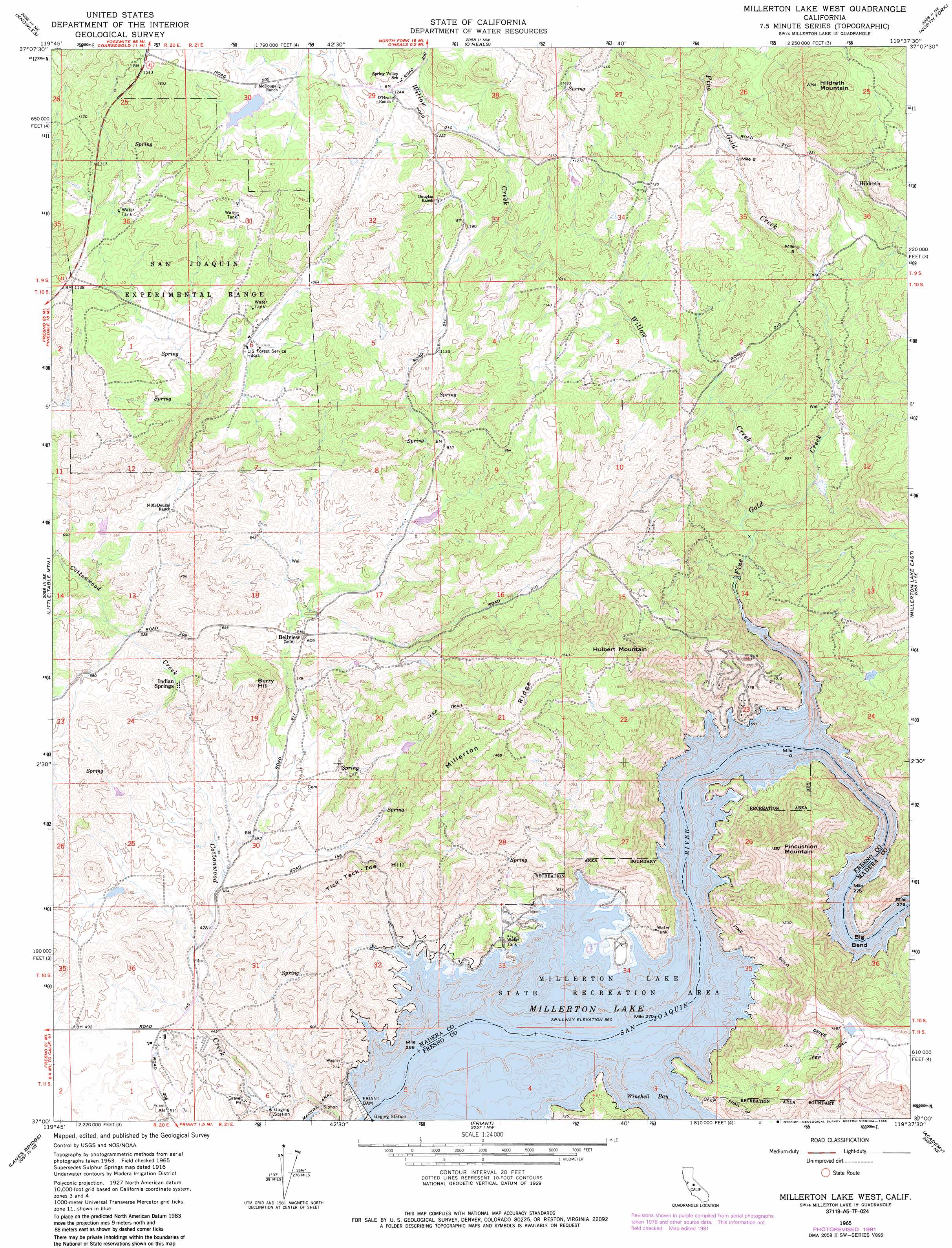
Millerton Lake West Topo Map California
To zoom in, hover over the map of Millerton Lake West
USGS Topo Quad 37119a6 - 1:24,000 scale
| Topo Map Name: | Millerton Lake West |
| USGS Topo Quad ID: | 37119a6 |
| Print Size: | ca. 21 1/4" wide x 27" high |
| Southeast Coordinates: | 37° N latitude / 119.625° W longitude |
| Map Center Coordinates: | 37.0625° N latitude / 119.6875° W longitude |
| U.S. State: | CA |
| Filename: | o37119a6.jpg |
| Download Map JPG Image: | Millerton Lake West topo map 1:24,000 scale |
| Map Type: | Topographic |
| Topo Series: | 7.5´ |
| Map Scale: | 1:24,000 |
| Source of Map Images: | United States Geological Survey (USGS) |
| Alternate Map Versions: |
Sulphur Springs CA 1916, updated 1959 Download PDF Buy paper map Millerton Lake West CA 1965, updated 1966 Download PDF Buy paper map Millerton Lake West CA 1965, updated 1981 Download PDF Buy paper map Millerton Lake West CA 1965, updated 1985 Download PDF Buy paper map Millerton Lake West CA 1965, updated 1985 Download PDF Buy paper map Millerton Lake West CA 2012 Download PDF Buy paper map Millerton Lake West CA 2015 Download PDF Buy paper map |
| FStopo: | US Forest Service topo Millerton Lake West is available: Download FStopo PDF Download FStopo TIF |
1:24,000 Topo Quads surrounding Millerton Lake West
Ben Hur |
Horsecamp Mountain |
Ahwahnee |
Bass Lake |
Shuteye Peak |
Raymond |
Knowles |
O'Neals |
North Fork |
Cascadel Point |
Daulton |
Little Table Mountain |
Millerton Lake West |
Millerton Lake East |
Auberry |
Gregg |
Lanes Bridge |
Friant |
Academy |
Humphreys Station |
Herndon |
Fresno North |
Clovis |
Round Mountain |
Piedra |
> Back to 37119a1 at 1:100,000 scale
> Back to 37118a1 at 1:250,000 scale
> Back to U.S. Topo Maps home
Millerton Lake West topo map: Gazetteer
Millerton Lake West: Bays
Dumna Cove elevation 171m 561′East Bay elevation 171m 561′
Finegold Bay elevation 171m 561′
Hills Cove elevation 171m 561′
Winchell Bay elevation 172m 564′
Millerton Lake West: Bends
Big Bend elevation 190m 623′Millerton Lake West: Capes
McKenzie Point elevation 186m 610′Millerton Lake West: Dams
Friant Dam elevation 171m 561′Millerton Lake West: Forests
San Joaquin Experimental Range elevation 349m 1145′Millerton Lake West: Islands
Dumna Island elevation 177m 580′Millerton Lake West: Parks
Kechaye Cultural Preserve elevation 318m 1043′Millerton Lake State Recreation Area elevation 184m 603′
Millerton Lake West: Populated Places
Fort Miller (historical) elevation 171m 561′Hildreth elevation 380m 1246′
Indian Springs elevation 160m 524′
Millerton Lake West: Reservoirs
Millerton Lake elevation 171m 561′Millerton Lake West: Ridges
Millerton Ridge elevation 427m 1400′Millerton Lake West: Streams
Fine Gold Creek elevation 171m 561′Willow Creek elevation 200m 656′
Millerton Lake West: Summits
Berry Hill elevation 279m 915′Hildreth Mountain elevation 625m 2050′
Hulbert Mountain elevation 559m 1833′
Perkins West Peak elevation 429m 1407′
Tick-Tack-Toe Hill elevation 266m 872′
Millerton Lake West: Trails
Buzzards Roost Trail elevation 196m 643′Millerton Lake West digital topo map on disk
Buy this Millerton Lake West topo map showing relief, roads, GPS coordinates and other geographical features, as a high-resolution digital map file on DVD: