Bass Lake Topo Map California
To zoom in, hover over the map of Bass Lake
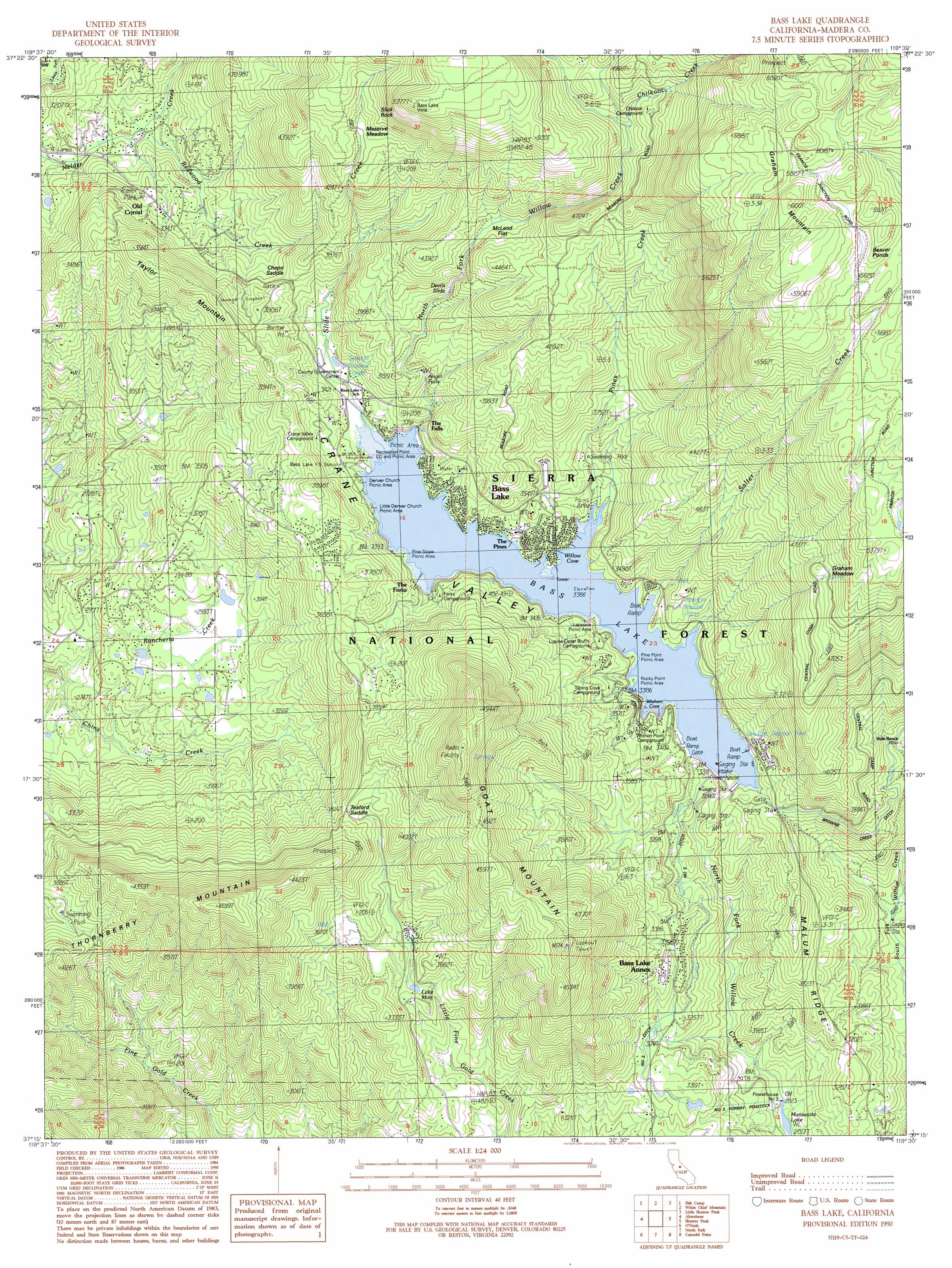
USGS Topo Quad 37119c5 - 1:24,000 scale
| Topo Map Name: | Bass Lake |
| USGS Topo Quad ID: | 37119c5 |
| Print Size: | ca. 21 1/4" wide x 27" high |
| Southeast Coordinates: | 37.25° N latitude / 119.5° W longitude |
| Map Center Coordinates: | 37.3125° N latitude / 119.5625° W longitude |
| U.S. State: | CA |
| Filename: | o37119c5.jpg |
| Download Map JPG Image: | Bass Lake topo map 1:24,000 scale |
| Map Type: | Topographic |
| Topo Series: | 7.5´ |
| Map Scale: | 1:24,000 |
| Source of Map Images: | United States Geological Survey (USGS) |
| Alternate Map Versions: |
Bass Lake CA 1990, updated 1990 Download PDF Buy paper map Bass Lake CA 1993, updated 2002 Download PDF Buy paper map Bass Lake CA 2004, updated 2007 Download PDF Buy paper map Bass Lake CA 2012 Download PDF Buy paper map Bass Lake CA 2015 Download PDF Buy paper map |
| FStopo: | US Forest Service topo Bass Lake is available: Download FStopo PDF Download FStopo TIF |
1:24,000 Topo Quads surrounding Bass Lake
Buckingham Mountain |
Wawona |
Mariposa Grove |
Sing Peak |
Timber Knob |
Stumpfield Mountain |
Fish Camp |
White Chief Mountain |
Little Shuteye Peak |
Squaw Dome |
Horsecamp Mountain |
Ahwahnee |
Bass Lake |
Shuteye Peak |
Mammoth Pool Dam |
Knowles |
O'Neals |
North Fork |
Cascadel Point |
Musick Mountain |
Little Table Mountain |
Millerton Lake West |
Millerton Lake East |
Auberry |
Shaver Lake |
> Back to 37119a1 at 1:100,000 scale
> Back to 37118a1 at 1:250,000 scale
> Back to U.S. Topo Maps home
Bass Lake topo map: Gazetteer
Bass Lake: Airports
Wishon Airport (historical) elevation 1036m 3398′Bass Lake: Areas
Effluent Field elevation 1121m 3677′Bass Lake: Bays
Willow Cove elevation 1027m 3369′Wishon Cove elevation 1027m 3369′
Bass Lake: Canals
Browns Creek Ditch elevation 1065m 3494′Number Three Ditch elevation 987m 3238′
Number Three Forbay Penstock elevation 933m 3061′
Bass Lake: Dams
Crane Valley Storage 95-003 Dam elevation 1001m 3284′Number 3 Forebay 95-006 Dam elevation 982m 3221′
Bass Lake: Falls
Angle Falls elevation 1112m 3648′Bass Lake: Flats
Graham Meadow elevation 1444m 4737′McLeod Flat elevation 1265m 4150′
Meserve Meadow elevation 1343m 4406′
Bass Lake: Gaps
Chepo Saddle elevation 1121m 3677′Teaford Saddle elevation 1144m 3753′
Bass Lake: Lakes
Lake Moic elevation 1061m 3480′Bass Lake: Populated Places
Bass Lake elevation 1041m 3415′Bass Lake Annex elevation 1027m 3369′
Old Corral elevation 1009m 3310′
The Pines elevation 1047m 3435′
Bass Lake: Post Offices
Bass Lake Post Office elevation 1043m 3421′Bass Lake Post Office (historical) elevation 1041m 3415′
Bass Lake: Rapids
Devils Slide elevation 1188m 3897′Bass Lake: Reservoirs
Bass Lake elevation 1027m 3369′Bass Lake: Slopes
Slick Rock elevation 1523m 4996′Bass Lake: Streams
Chilkoot Creek elevation 1371m 4498′Pines Creek elevation 1029m 3375′
Rancheria Creek elevation 792m 2598′
Redwood Creek elevation 918m 3011′
Salter Creek elevation 1028m 3372′
Slide Creek elevation 1032m 3385′
Bass Lake: Summits
Goat Mountain elevation 1514m 4967′Graham Mountain elevation 1857m 6092′
Taylor Mountain elevation 1207m 3959′
Thornberry Mountain elevation 1429m 4688′
Bass Lake: Trails
Goat Mountain Trail elevation 1255m 4117′Way of the Mono Trail elevation 1051m 3448′
Willow Creek Trail elevation 1163m 3815′
Bass Lake: Valleys
Crane Valley elevation 1036m 3398′Bass Lake digital topo map on disk
Buy this Bass Lake topo map showing relief, roads, GPS coordinates and other geographical features, as a high-resolution digital map file on DVD: