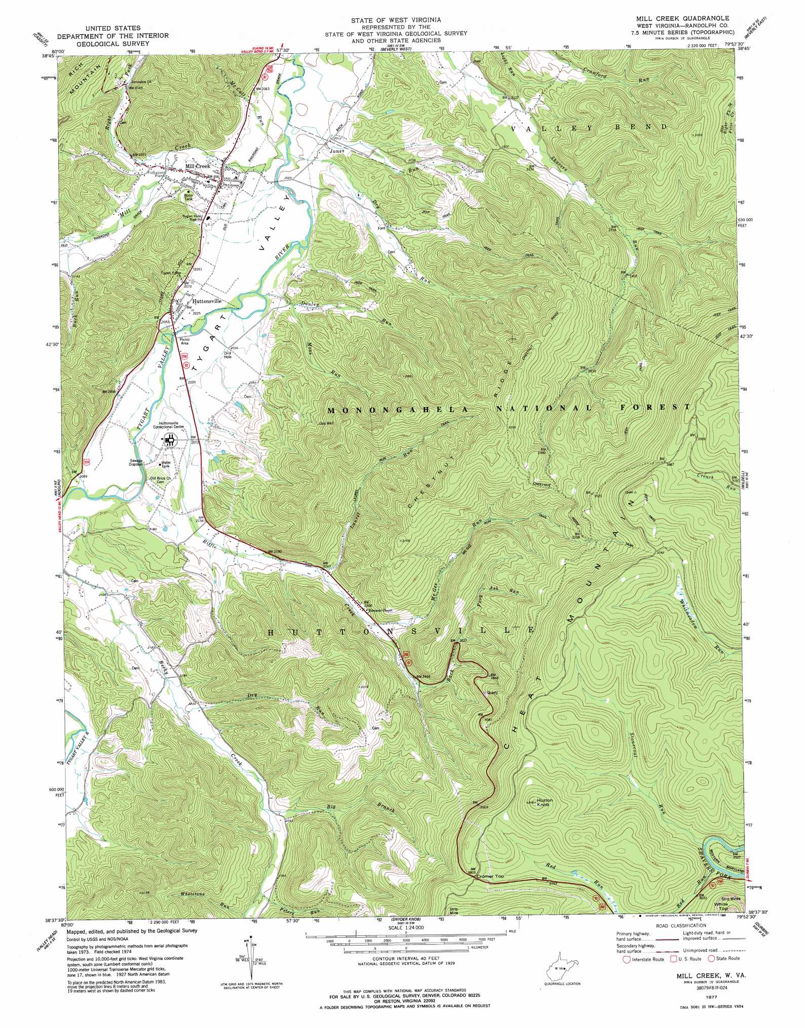
Mill Creek Topo Map West Virginia
To zoom in, hover over the map of Mill Creek
USGS Topo Quad 38079f8 - 1:24,000 scale
| Topo Map Name: | Mill Creek |
| USGS Topo Quad ID: | 38079f8 |
| Print Size: | ca. 21 1/4" wide x 27" high |
| Southeast Coordinates: | 38.625° N latitude / 79.875° W longitude |
| Map Center Coordinates: | 38.6875° N latitude / 79.9375° W longitude |
| U.S. State: | WV |
| Filename: | o38079f8.jpg |
| Download Map JPG Image: | Mill Creek topo map 1:24,000 scale |
| Map Type: | Topographic |
| Topo Series: | 7.5´ |
| Map Scale: | 1:24,000 |
| Source of Map Images: | United States Geological Survey (USGS) |
| Alternate Map Versions: |
Mill Creek WV 1977, updated 1977 Download PDF Buy paper map Mill Creek WV 1977, updated 1989 Download PDF Buy paper map Mill Creek WV 1995, updated 1998 Download PDF Buy paper map Mill Creek WV 2011 Download PDF Buy paper map Mill Creek WV 2014 Download PDF Buy paper map Mill Creek WV 2016 Download PDF Buy paper map |
| FStopo: | US Forest Service topo Mill Creek is available: Download FStopo PDF Download FStopo TIF |
1:24,000 Topo Quads surrounding Mill Creek
Buckhannon |
Ellamore |
Junior |
Elkins |
Bowden |
Alton |
Cassity |
Beverly West |
Beverly East |
Glady |
Pickens |
Adolph |
Mill Creek |
Wildell |
Sinks Of Gandy |
Samp |
Valley Head |
Snyder Knob |
Durbin |
Thornwood |
Sharp Knob |
Mingo |
Cass |
Green Bank |
Hightown |
> Back to 38079e1 at 1:100,000 scale
> Back to 38078a1 at 1:250,000 scale
> Back to U.S. Topo Maps home
Mill Creek topo map: Gazetteer
Mill Creek: Gaps
Cromer Top elevation 1159m 3802′Mill Creek: Parks
Cheat Wildlife Management Area elevation 1148m 3766′Huttonsville State Farm Wildlife Management Area elevation 645m 2116′
Mill Creek: Populated Places
Huttonsville elevation 621m 2037′Mill Creek elevation 623m 2043′
Mill Creek: Ridges
Chestnut Ridge elevation 1044m 3425′Mill Creek: Streams
Ash Run elevation 852m 2795′Back Fork elevation 740m 2427′
Big Branch elevation 701m 2299′
Buck Run elevation 651m 2135′
Donley Run elevation 614m 2014′
Dry Run elevation 666m 2185′
Dry Run elevation 608m 1994′
Jones Run elevation 608m 1994′
Laurel Run elevation 683m 2240′
McCall Run elevation 609m 1998′
McGee Run elevation 711m 2332′
Mill Creek elevation 610m 2001′
Moss Run elevation 625m 2050′
Peters Run elevation 732m 2401′
Red Run elevation 1108m 3635′
Riffle Creek elevation 619m 2030′
Right Fork Mill Creek elevation 621m 2037′
Stonecoal Run elevation 1075m 3526′
Whetstone Run elevation 740m 2427′
Mill Creek: Summits
Hutton Knob elevation 1291m 4235′Mill Creek: Trails
Chestnut Ridge Trail elevation 1028m 3372′Laurel Run Trail elevation 765m 2509′
McGee Run Trail elevation 832m 2729′
Stonecoal Hunter Access Trail elevation 1211m 3973′
Mill Creek: Valleys
Ward Hollow elevation 640m 2099′Mill Creek digital topo map on disk
Buy this Mill Creek topo map showing relief, roads, GPS coordinates and other geographical features, as a high-resolution digital map file on DVD:
Western Virginia & Southern West Virginia
Buy digital topo maps: Western Virginia & Southern West Virginia