Charleston East Topo Map West Virginia
To zoom in, hover over the map of Charleston East
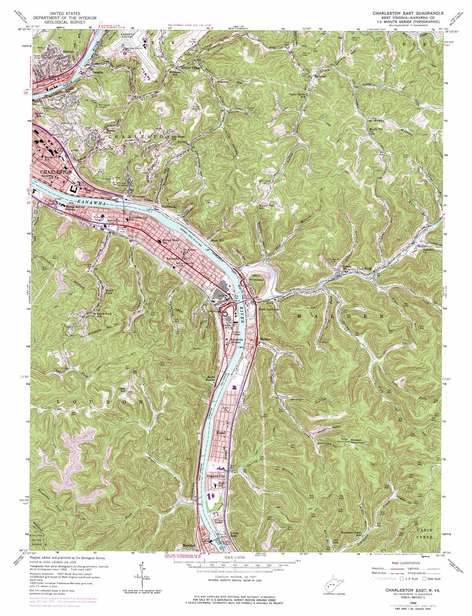
USGS Topo Quad 38081c5 - 1:24,000 scale
| Topo Map Name: | Charleston East |
| USGS Topo Quad ID: | 38081c5 |
| Print Size: | ca. 21 1/4" wide x 27" high |
| Southeast Coordinates: | 38.25° N latitude / 81.5° W longitude |
| Map Center Coordinates: | 38.3125° N latitude / 81.5625° W longitude |
| U.S. State: | WV |
| Filename: | o38081c5.jpg |
| Download Map JPG Image: | Charleston East topo map 1:24,000 scale |
| Map Type: | Topographic |
| Topo Series: | 7.5´ |
| Map Scale: | 1:24,000 |
| Source of Map Images: | United States Geological Survey (USGS) |
| Alternate Map Versions: |
Charleston East WV 1957, updated 1959 Download PDF Buy paper map Charleston East WV 1957, updated 1966 Download PDF Buy paper map Charleston East WV 1957, updated 1973 Download PDF Buy paper map Charleston East WV 1958, updated 1978 Download PDF Buy paper map Charleston East WV 1977, updated 1980 Download PDF Buy paper map Charleston East WV 1996, updated 2000 Download PDF Buy paper map Charleston East WV 2011 Download PDF Buy paper map Charleston East WV 2014 Download PDF Buy paper map Charleston East WV 2016 Download PDF Buy paper map |
1:24,000 Topo Quads surrounding Charleston East
Bancroft |
Sissonville |
Romance |
Kettle |
Clio |
Saint Albans |
Pocatalico |
Big Chimney |
Blue Creek |
Clendenin |
Alum Creek |
Charleston West |
Charleston East |
Quick |
Mammoth |
Julian |
Racine |
Belle |
Cedar Grove |
Montgomery |
Madison |
Williams Mountain |
Sylvester |
Eskdale |
Powellton |
> Back to 38081a1 at 1:100,000 scale
> Back to 38080a1 at 1:250,000 scale
> Back to U.S. Topo Maps home
Charleston East topo map: Gazetteer
Charleston East: Airports
CAMC Memorial Helistop - ground level elevation 179m 587′Yeager Airport elevation 287m 941′
Charleston East: Bridges
Kanawha City Bridge elevation 174m 570′Yeager Bridge elevation 174m 570′
Charleston East: Crossings
Interchange 100 elevation 188m 616′Interchange 102 elevation 186m 610′
Interchange 95 elevation 196m 643′
Interchange 96 elevation 203m 666′
Interchange 97 elevation 184m 603′
Interchange 98 elevation 196m 643′
Interchange 99 elevation 195m 639′
Charleston East: Dams
Elk Twomile Creek Structure Number 13 Dam elevation 288m 944′Elk Twomile Structure Number 12 Dam elevation 302m 990′
Lock 5 (historical) elevation 174m 570′
Marmet Locks elevation 178m 583′
Marmet Locks and Dam elevation 379m 1243′
Scotts Run Cinder Barrier Dam elevation 406m 1332′
Charleston East: Parks
Blackwell Field elevation 181m 593′Daniel Boone Park elevation 183m 600′
East End Historic District elevation 185m 606′
Kanawha Riflemens Memorial Park elevation 186m 610′
Laidley Field elevation 185m 606′
Spring Hill Cemetery Historic District elevation 271m 889′
Walt Powell Park elevation 181m 593′
Watt Powell Stadium elevation 182m 597′
Charleston East: Populated Places
Airport Village elevation 192m 629′Blackhawk elevation 189m 620′
Coal Fork elevation 201m 659′
Dupont City elevation 187m 613′
Hillsdale elevation 276m 905′
Kanawha City elevation 186m 610′
Kanawha Estates elevation 183m 600′
Lower Belle elevation 185m 606′
Malden elevation 182m 597′
Port Amherst elevation 185m 606′
Rand elevation 187m 613′
Riverview elevation 184m 603′
Rutledge elevation 226m 741′
Snow Hill elevation 184m 603′
South Malden elevation 183m 600′
South Park elevation 225m 738′
South Ruffner elevation 182m 597′
Twomile elevation 184m 603′
Charleston East: Post Offices
Coal Fork Post Office elevation 188m 616′Kanawha City Post Office elevation 187m 613′
Malden Post Office elevation 186m 610′
Rand Post Office (historical) elevation 185m 606′
Charleston East: Reservoirs
Cool Lake elevation 220m 721′Dupont Waste Lake elevation 406m 1332′
Charleston East: Springs
Carl Woods Spring elevation 228m 748′Columbia Carbon Company Spring elevation 220m 721′
Charleston East: Streams
Baker Fork elevation 190m 623′Burning Spring Branch elevation 174m 570′
Campbells Creek elevation 173m 567′
Chappel Branch elevation 181m 593′
Coal Fork elevation 186m 610′
Dry Branch elevation 176m 577′
Elk Twomile Creek elevation 175m 574′
Georges Creek elevation 174m 570′
Hanson Branch elevation 209m 685′
Kelly Branch elevation 209m 685′
Left Fork Spring Fork elevation 224m 734′
Lick Branch elevation 173m 567′
Little Spring Fork elevation 185m 606′
Lower Donnally Branch elevation 173m 567′
Magazine Branch elevation 181m 593′
Pointlick Fork elevation 190m 623′
Right Fork Coal Fork elevation 195m 639′
Right Fork Rush Creek elevation 179m 587′
Rush Creek elevation 174m 570′
Spring Fork elevation 181m 593′
Upper Donnally Branch elevation 196m 643′
Valley Grove Branch elevation 216m 708′
Venable Branch elevation 176m 577′
Wash Branch elevation 192m 629′
Younger Branch elevation 187m 613′
Charleston East: Summits
Malden Mountain elevation 455m 1492′Charleston East: Valleys
Blackhawk Hollow elevation 184m 603′Blacksnake Hollow elevation 275m 902′
Brooks Hollow elevation 191m 626′
Campbells Hollow elevation 242m 793′
Chappell Hollow elevation 187m 613′
Clover Hollow elevation 195m 639′
Cooks Hollow elevation 182m 597′
Crouch Hollow elevation 218m 715′
Flood Hollow elevation 243m 797′
Gill Hollow elevation 186m 610′
Green Bottom elevation 239m 784′
Harris Hollow elevation 201m 659′
Hawes Hollow elevation 197m 646′
Hogpen Hollow elevation 255m 836′
Larkin Hollow elevation 226m 741′
Martin Hollow elevation 223m 731′
Mission Hollow elevation 186m 610′
Nunley Hollow elevation 191m 626′
Payton Hollow elevation 261m 856′
Ruffner Hollow elevation 198m 649′
Shoot Hollow elevation 228m 748′
Westfall Hollow elevation 210m 688′
Charleston East digital topo map on disk
Buy this Charleston East topo map showing relief, roads, GPS coordinates and other geographical features, as a high-resolution digital map file on DVD:
Western Virginia & Southern West Virginia
Buy digital topo maps: Western Virginia & Southern West Virginia