Ocheltree Topo Map Kansas
To zoom in, hover over the map of Ocheltree
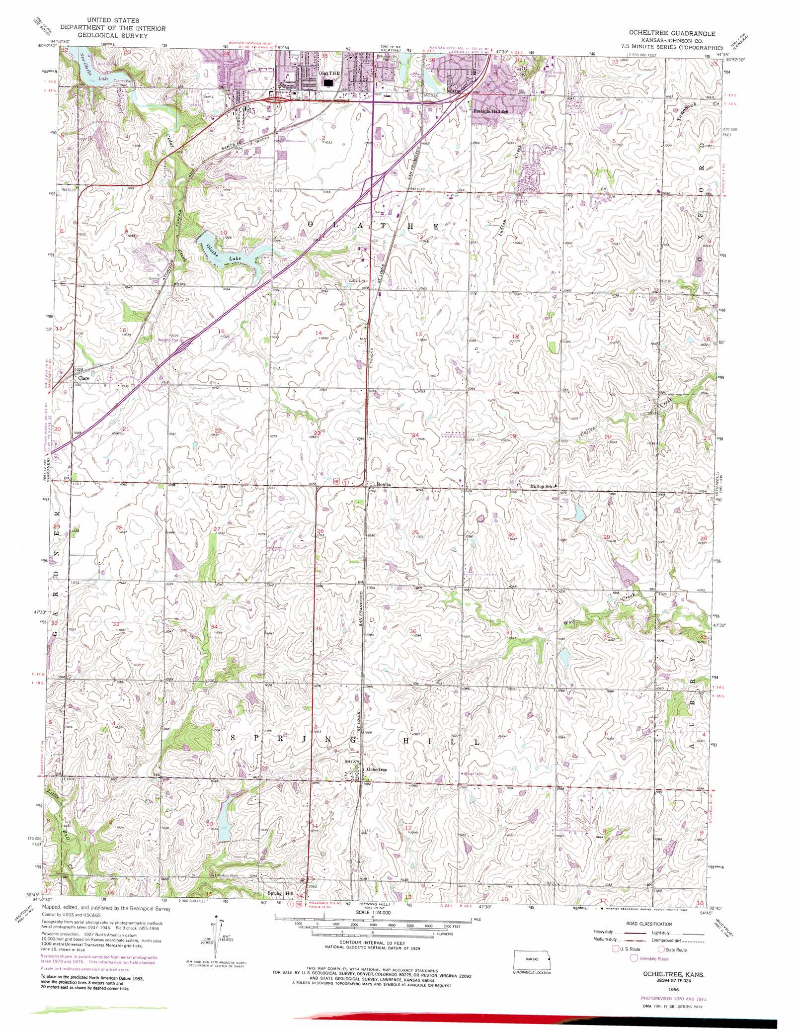
USGS Topo Quad 38094g7 - 1:24,000 scale
| Topo Map Name: | Ocheltree |
| USGS Topo Quad ID: | 38094g7 |
| Print Size: | ca. 21 1/4" wide x 27" high |
| Southeast Coordinates: | 38.75° N latitude / 94.75° W longitude |
| Map Center Coordinates: | 38.8125° N latitude / 94.8125° W longitude |
| U.S. State: | KS |
| Filename: | o38094g7.jpg |
| Download Map JPG Image: | Ocheltree topo map 1:24,000 scale |
| Map Type: | Topographic |
| Topo Series: | 7.5´ |
| Map Scale: | 1:24,000 |
| Source of Map Images: | United States Geological Survey (USGS) |
| Alternate Map Versions: |
Ocheltree KS 1956, updated 1957 Download PDF Buy paper map Ocheltree KS 1956, updated 1971 Download PDF Buy paper map Ocheltree KS 1956, updated 1976 Download PDF Buy paper map Ocheltree KS 1956, updated 1986 Download PDF Buy paper map Ocheltree KS 1991, updated 1996 Download PDF Buy paper map Ocheltree KS 2009 Download PDF Buy paper map Ocheltree KS 2012 Download PDF Buy paper map Ocheltree KS 2015 Download PDF Buy paper map |
1:24,000 Topo Quads surrounding Ocheltree
Tonganoxie |
Bonner Springs |
Edwardsville |
Shawnee |
Kansas City |
Eudora |
De Soto |
Olathe |
Lenexa |
Grandview |
Edgerton |
Gardner |
Ocheltree |
Stilwell |
Belton |
Wellsville |
Antioch |
Spring Hill |
Bucyrus |
West Line |
Rantoul |
Paola West |
Paola East |
Louisburg |
Freeman |
> Back to 38094e1 at 1:100,000 scale
> Back to 38094a1 at 1:250,000 scale
> Back to U.S. Topo Maps home
Ocheltree topo map: Gazetteer
Ocheltree: Airports
Flying V Airport elevation 319m 1046′Neumanns Airport elevation 330m 1082′
Ocheltree: Crossings
Interchange 210 elevation 321m 1053′Interchange 215 elevation 328m 1076′
Ocheltree: Dams
Frisco Lake Park Dam elevation 315m 1033′Ocheltree: Lakes
Blackbob Park Pond elevation 323m 1059′Frisco Lake elevation 317m 1040′
Olathe East High School Pond elevation 322m 1056′
Waterworks Lake South elevation 313m 1026′
Ocheltree: Parks
Arrowhead Park elevation 315m 1033′Black Bob Pool elevation 331m 1085′
Blackbob Park elevation 330m 1082′
Blackbob School Park elevation 322m 1056′
Brougham Park elevation 322m 1056′
Cedar Lake Park elevation 310m 1017′
Frisco Lake Park elevation 318m 1043′
Harvest Prayer Sculpture and Campus Mall elevation 321m 1053′
Haven Park elevation 321m 1053′
Havencroft School Park elevation 310m 1017′
Heritage Park Golf Course elevation 316m 1036′
Heritage Soccer Park elevation 330m 1082′
Lake Olathe Beach elevation 290m 951′
Naval Air Park elevation 317m 1040′
Oregon Trail Park elevation 317m 1040′
Oregon Trail Pool elevation 318m 1043′
Parkhill Manor Park elevation 315m 1033′
Pioneer Stadium elevation 321m 1053′
Robbie Jones Field elevation 320m 1049′
South Frisco Lake elevation 319m 1046′
Southdowns Park elevation 318m 1043′
Spring Hill Pool elevation 323m 1059′
Water Works Park elevation 314m 1030′
Williams Field elevation 322m 1056′
Ocheltree: Populated Places
Bonita elevation 335m 1099′Clare elevation 312m 1023′
Ocheltree elevation 331m 1085′
Ocheltree: Post Offices
Dillions Number 6 Post Office elevation 328m 1076′Ocheltree: Reservoirs
Olathe Lake elevation 301m 987′Spring Hill City Lake elevation 306m 1003′
Ocheltree digital topo map on disk
Buy this Ocheltree topo map showing relief, roads, GPS coordinates and other geographical features, as a high-resolution digital map file on DVD: