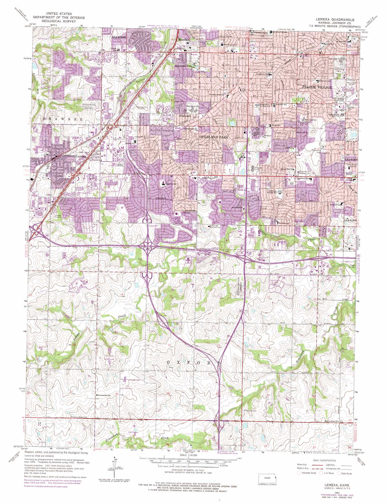
Lenexa Topo Map Kansas
To zoom in, hover over the map of Lenexa
USGS Topo Quad 38094h6 - 1:24,000 scale
| Topo Map Name: | Lenexa |
| USGS Topo Quad ID: | 38094h6 |
| Print Size: | ca. 21 1/4" wide x 27" high |
| Southeast Coordinates: | 38.875° N latitude / 94.625° W longitude |
| Map Center Coordinates: | 38.9375° N latitude / 94.6875° W longitude |
| U.S. State: | KS |
| Filename: | o38094h6.jpg |
| Download Map JPG Image: | Lenexa topo map 1:24,000 scale |
| Map Type: | Topographic |
| Topo Series: | 7.5´ |
| Map Scale: | 1:24,000 |
| Source of Map Images: | United States Geological Survey (USGS) |
| Alternate Map Versions: |
Lenexa KS 1935 Download PDF Buy paper map Lenexa KS 1935, updated 1954 Download PDF Buy paper map Lenexa KS 1957, updated 1958 Download PDF Buy paper map Lenexa KS 1963, updated 1964 Download PDF Buy paper map Lenexa KS 1963, updated 1971 Download PDF Buy paper map Lenexa KS 1963, updated 1976 Download PDF Buy paper map Lenexa KS 1991, updated 1995 Download PDF Buy paper map Lenexa KS 2009 Download PDF Buy paper map Lenexa KS 2012 Download PDF Buy paper map Lenexa KS 2015 Download PDF Buy paper map |
1:24,000 Topo Quads surrounding Lenexa
Basehor |
Wolcott |
Parkville |
North Kansas City |
Liberty |
Bonner Springs |
Edwardsville |
Shawnee |
Kansas City |
Independence |
De Soto |
Olathe |
Lenexa |
Grandview |
Lees Summit |
Gardner |
Ocheltree |
Stilwell |
Belton |
Raymore |
Antioch |
Spring Hill |
Bucyrus |
West Line |
Peculiar |
> Back to 38094e1 at 1:100,000 scale
> Back to 38094a1 at 1:250,000 scale
> Back to U.S. Topo Maps home
Lenexa topo map: Gazetteer
Lenexa: Airports
Glenwood Manor Motor Hotel Airport elevation 288m 944′Lenexa: Crossings
Interchange 224 elevation 313m 1026′Interchange 225A elevation 315m 1033′
Interchange 225B elevation 312m 1023′
Interchange 227 elevation 300m 984′
Interchange 77A elevation 266m 872′
Interchange 77B elevation 277m 908′
Interchange 79 elevation 280m 918′
Interchange 81 elevation 287m 941′
Interchange 82 elevation 285m 935′
Lenexa: Lakes
Heatherstone Pond elevation 302m 990′Lenexa Resurrection Pond elevation 303m 994′
Nagwika Lake elevation 302m 990′
Overland Park South Lake elevation 305m 1000′
Stoll Park Lake elevation 298m 977′
Summercrest Lake elevation 280m 918′
Tomahawk Parkway Middle Pond elevation 256m 839′
Tomahawk Parkway South Pond elevation 259m 849′
Lenexa: Parks
Antioch Acres Park elevation 310m 1017′Antioch Square Park elevation 317m 1040′
Austin Harmon Park elevation 319m 1046′
Austin Harmon Park Pool elevation 316m 1036′
Bennett Park elevation 303m 994′
Beth Torah Park elevation 268m 879′
Blue Valley Northwest High School and District Stadium Complex elevation 307m 1007′
Blue Valley Recreation Complex elevation 288m 944′
Bradshaw Park elevation 313m 1026′
Brookridge Park elevation 275m 902′
Cherokee Park elevation 294m 964′
City Hall Park elevation 324m 1062′
City of Leawood Parks and Recreation Department elevation 281m 921′
City of Lenexa Parks and Recreation Department elevation 320m 1049′
Clock Tower Plaza Park elevation 331m 1085′
Cobblestone Park elevation 285m 935′
Comanche Park elevation 304m 997′
Corporate Woods North Park elevation 274m 898′
Corporate Woods South Park elevation 275m 902′
Cross Creek Park elevation 319m 1046′
Deanna Rose Children's Farmstead elevation 290m 951′
Fairway Woods Park elevation 300m 984′
Flat Rock Creek Park elevation 297m 974′
Flat Rock Creek Pool elevation 294m 964′
Forest Creek Park elevation 289m 948′
Foxhill North Park elevation 259m 849′
Foxhill South Park elevation 257m 843′
Franklin Park elevation 292m 958′
Gillette Park elevation 305m 1000′
Hanover Park elevation 278m 912′
Hawthorne Valley Park elevation 264m 866′
Heatherstone Park elevation 308m 1010′
Indian Creek Recreation Center elevation 286m 938′
Indian Valley Park elevation 279m 915′
James Place Park elevation 264m 866′
John McNerney Park elevation 308m 1010′
Kensington Park elevation 320m 1049′
Linwood Park elevation 290m 951′
Little Mill Creek North Park elevation 283m 928′
Little Mill Creek South Park elevation 278m 912′
Louisburg Square Park elevation 316m 1036′
Maple Hills Park elevation 325m 1066′
Marty Park elevation 326m 1069′
Marty Pool elevation 326m 1069′
Matt Taylor Park elevation 315m 1033′
Miller Woods Recreation Complex elevation 291m 954′
Molamphy Park elevation 300m 984′
Nall Hill Park elevation 276m 905′
Nall Park elevation 263m 862′
Nottingham Downs Park elevation 273m 895′
Nottingham Downs Park elevation 273m 895′
Nottingham South Park elevation 282m 925′
Oak Park elevation 287m 941′
Oak Valley Park elevation 282m 925′
Overland Park Community Park elevation 299m 980′
Pinehurst East Park elevation 263m 862′
Pinehurst Estates Park elevation 276m 905′
Pinehurst West Park elevation 262m 859′
Porter Park elevation 285m 935′
Post Oak Park elevation 297m 974′
Prairie View Park elevation 316m 1036′
Quivira Park elevation 286m 938′
Rock Creek Park elevation 294m 964′
Roe Park elevation 261m 856′
Roe Pool elevation 262m 859′
Rosehill East Park elevation 286m 938′
Rosehill East Park elevation 286m 938′
Rosehill Park elevation 289m 948′
Rosehill Park elevation 289m 948′
Santa Fe Commons Park elevation 332m 1089′
Santa Fe Trail Park elevation 312m 1023′
Sapling Grove Park elevation 299m 980′
Scouting Park elevation 318m 1043′
Shannon Valley Park elevation 278m 912′
South Lake Park elevation 307m 1007′
Stonegate Park elevation 280m 918′
Stonegate Pool elevation 280m 918′
Strang Park elevation 328m 1076′
Summercrest Park elevation 290m 951′
Thomas Stoll Memorial Park elevation 309m 1013′
Tomahawk North Park elevation 260m 853′
Tomahawk Ridge Aquatic Center elevation 303m 994′
Tomahawk Ridge Community Center and Aquatic Center elevation 307m 1007′
Tomahawk South Park elevation 263m 862′
Tomahawk Valley Park elevation 296m 971′
Trafalgar Park elevation 306m 1003′
Valleybrooke Park elevation 281m 921′
Westbrooke Park elevation 327m 1072′
Westgate Park elevation 291m 954′
Windham Creek Park elevation 288m 944′
Windham Hill Park elevation 311m 1020′
Windsor Park elevation 286m 938′
Yougs Park elevation 309m 1013′
Young's Park elevation 310m 1017′
Young's Pool elevation 308m 1010′
Lenexa: Populated Places
Elmhurst elevation 325m 1066′Lenexa elevation 314m 1030′
Overland Park elevation 330m 1082′
Prairie Village elevation 302m 990′
Lenexa: Post Offices
Blue Valley Branch Post Office elevation 312m 1023′Brookridge Branch Post Office elevation 280m 918′
Indian Creek Branch Post Office elevation 260m 853′
Leawood Branch Post Office elevation 294m 964′
Lenexa Branch Post Office elevation 326m 1069′
Overland Park Post Office elevation 329m 1079′
Oxford Carrier Annex Post Office elevation 329m 1079′
Prairie Village Branch Post Office elevation 295m 967′
Lenexa: Trails
Indian Creek Bike and Hike Trail elevation 264m 866′Tomahawk Creek Trail elevation 283m 928′
Lenexa digital topo map on disk
Buy this Lenexa topo map showing relief, roads, GPS coordinates and other geographical features, as a high-resolution digital map file on DVD: