Sanborn Park Topo Map Colorado
To zoom in, hover over the map of Sanborn Park
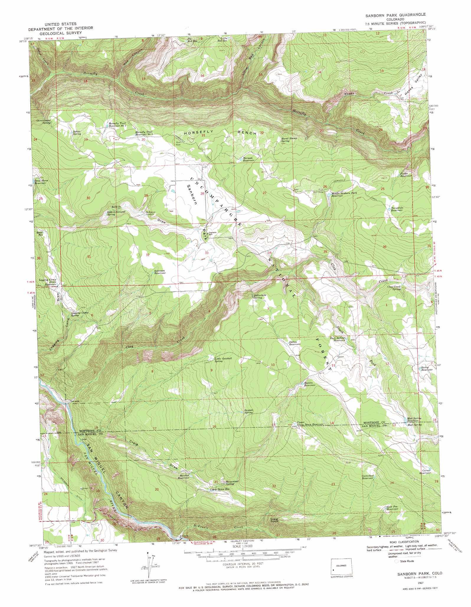
USGS Topo Quad 38108b2 - 1:24,000 scale
| Topo Map Name: | Sanborn Park |
| USGS Topo Quad ID: | 38108b2 |
| Print Size: | ca. 21 1/4" wide x 27" high |
| Southeast Coordinates: | 38.125° N latitude / 108.125° W longitude |
| Map Center Coordinates: | 38.1875° N latitude / 108.1875° W longitude |
| U.S. State: | CO |
| Filename: | o38108b2.jpg |
| Download Map JPG Image: | Sanborn Park topo map 1:24,000 scale |
| Map Type: | Topographic |
| Topo Series: | 7.5´ |
| Map Scale: | 1:24,000 |
| Source of Map Images: | United States Geological Survey (USGS) |
| Alternate Map Versions: |
Sanborn Park CO 1967, updated 1971 Download PDF Buy paper map Sanborn Park CO 1967, updated 1971 Download PDF Buy paper map Sanborn Park CO 1967, updated 1979 Download PDF Buy paper map Sanborn Park CO 2011 Download PDF Buy paper map Sanborn Park CO 2013 Download PDF Buy paper map Sanborn Park CO 2016 Download PDF Buy paper map |
| FStopo: | US Forest Service topo Sanborn Park is available: Download FStopo PDF Download FStopo TIF |
1:24,000 Topo Quads surrounding Sanborn Park
Starvation Point |
Moore Mesa |
Davis Point |
Dry Creek Basin |
Montrose West |
Big Bucktail Creek |
Ute |
Antone Spring |
Pryor Creek |
Government Springs |
Redvale |
Norwood |
Sanborn Park |
Hotchkiss Reservoir |
Horsefly Peak |
Barkelew Draw |
Oak Hill |
Gurley Canyon |
Placerville |
Sams |
North Mountain |
Lone Cone |
Beaver Park |
Little Cone |
Gray Head |
> Back to 38108a1 at 1:100,000 scale
> Back to 38108a1 at 1:250,000 scale
> Back to U.S. Topo Maps home
Sanborn Park topo map: Gazetteer
Sanborn Park: Benches
Horsefly Bench elevation 2409m 7903′Sanborn Park: Canals
Bolinger Ditch elevation 2223m 7293′Sanborn Park: Cliffs
Craig Point elevation 2350m 7709′Sanborn Park: Flats
Sanborn Park elevation 2377m 7798′Sanborn Park: Reservoirs
Berry Reservoir elevation 2526m 8287′Big Red Reservoir elevation 2346m 7696′
Cartwheel Reservoir elevation 2474m 8116′
Corner Reservoir elevation 2548m 8359′
Craig Draw Reservoir elevation 2277m 7470′
Dollan Reservoir elevation 2461m 8074′
Fisher Reservoir elevation 2472m 8110′
Goat Pen Reservoir elevation 2404m 7887′
Hardin Reservoir elevation 2466m 8090′
Herman Reservoir elevation 2431m 7975′
Horsefly Trail Reservoir Number 1 elevation 2364m 7755′
Horsefly Trail Reservoir Number 2 elevation 2382m 7814′
Little Red Reservoir elevation 2394m 7854′
Logging Camp Draw Reservoir elevation 2265m 7431′
Mavriat Reservoir elevation 2261m 7417′
Middle Sanborn Park Reservoir elevation 2465m 8087′
Mud Spring Reservoir elevation 2502m 8208′
Road Reservoir elevation 2278m 7473′
Rock Ballast Reservoir elevation 2434m 7985′
Sorenson Reservoir elevation 2393m 7851′
Tarantula Reservoir elevation 2508m 8228′
Upper Craig Draw Reservoir elevation 2467m 8093′
Sanborn Park: Springs
Burnt Stump Spring elevation 2422m 7946′Clay Creek Spring elevation 2453m 8047′
Dobler Spring elevation 2360m 7742′
Dollarhide Spring elevation 2397m 7864′
Government Spring elevation 2349m 7706′
Hole-in-Ground Spring elevation 2336m 7664′
Homestead Spring elevation 2312m 7585′
Impson Spring elevation 2421m 7942′
Little Gutshall Spring elevation 2404m 7887′
Logging Camp Spring elevation 2246m 7368′
Mud Spring elevation 2505m 8218′
Rocky Spring elevation 2166m 7106′
Sanborn Park: Streams
Clay Creek elevation 1944m 6377′Hanks Creek elevation 2217m 7273′
McKenzie Creek elevation 2005m 6578′
Sheep Creek elevation 2011m 6597′
South Fork Clay Creek elevation 2330m 7644′
Sanborn Park: Trails
Horsefly Trail elevation 2445m 8021′Sanborn Park: Valleys
Craig Draw elevation 1968m 6456′Hanks Valley elevation 2404m 7887′
Little Red Canyon elevation 2123m 6965′
Red Canyon elevation 2037m 6683′
Sanborn Park digital topo map on disk
Buy this Sanborn Park topo map showing relief, roads, GPS coordinates and other geographical features, as a high-resolution digital map file on DVD: