Peddler Hill Topo Map California
To zoom in, hover over the map of Peddler Hill
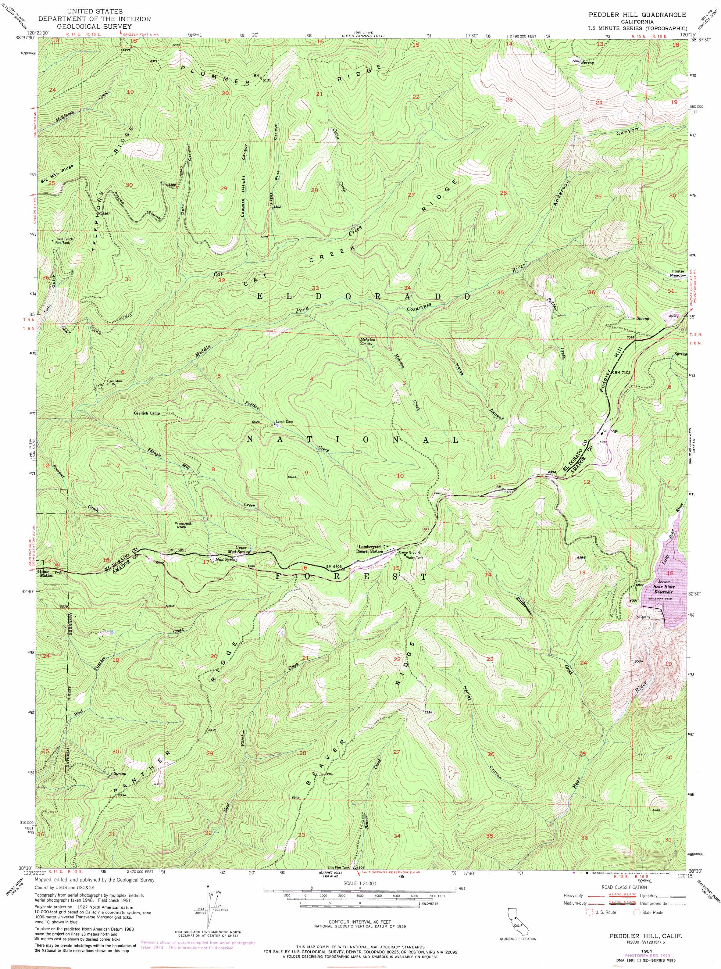
USGS Topo Quad 38120e3 - 1:24,000 scale
| Topo Map Name: | Peddler Hill |
| USGS Topo Quad ID: | 38120e3 |
| Print Size: | ca. 21 1/4" wide x 27" high |
| Southeast Coordinates: | 38.5° N latitude / 120.25° W longitude |
| Map Center Coordinates: | 38.5625° N latitude / 120.3125° W longitude |
| U.S. State: | CA |
| Filename: | o38120e3.jpg |
| Download Map JPG Image: | Peddler Hill topo map 1:24,000 scale |
| Map Type: | Topographic |
| Topo Series: | 7.5´ |
| Map Scale: | 1:24,000 |
| Source of Map Images: | United States Geological Survey (USGS) |
| Alternate Map Versions: |
Peddler Hill CA 1951, updated 1953 Download PDF Buy paper map Peddler Hill CA 1951, updated 1956 Download PDF Buy paper map Peddler Hill CA 1951, updated 1974 Download PDF Buy paper map Peddler Hill CA 1951, updated 1980 Download PDF Buy paper map Peddler Hill CA 2012 Download PDF Buy paper map Peddler Hill CA 2015 Download PDF Buy paper map |
| FStopo: | US Forest Service topo Peddler Hill is available: Download FStopo PDF Download FStopo TIF |
1:24,000 Topo Quads surrounding Peddler Hill
Pollock Pines |
Riverton |
Kyburz |
Pyramid Peak |
Echo Lake |
Sly Park |
Old Iron Mountain |
Leek Spring Hill |
Tragedy Spring |
Caples Lake |
Omo Ranch |
Caldor |
Peddler Hill |
Bear River Reservoir |
Mokelumne Peak |
West Point |
Devils Nose |
Garnet Hill |
Calaveras Dome |
Tamarack |
Rail Road Flat |
Fort Mountain |
Dorrington |
Boards Crossing |
Liberty Hill |
> Back to 38120e1 at 1:100,000 scale
> Back to 38120a1 at 1:250,000 scale
> Back to U.S. Topo Maps home
Peddler Hill topo map: Gazetteer
Peddler Hill: Dams
Lower Bear River 97-115 Dam elevation 1774m 5820′Lynch Dam elevation 1673m 5488′
Peddler Hill: Mines
Tiger Mine elevation 1370m 4494′Peddler Hill: Pillars
Prospect Rock elevation 1722m 5649′Peddler Hill: Reservoirs
Ellis Fire Tank elevation 1392m 4566′Lower Bear River Reservoir elevation 1774m 5820′
Twin Gulch Fire Tank elevation 1555m 5101′
Peddler Hill: Ridges
Beaver Ridge elevation 1615m 5298′Cat Creek Ridge elevation 1796m 5892′
Panther Ridge elevation 1488m 4881′
Telephone Ridge elevation 1783m 5849′
Peddler Hill: Springs
Mehrten Spring elevation 1690m 5544′Mud Spring elevation 1823m 5980′
Upper Mud Spring elevation 1815m 5954′
Peddler Hill: Streams
Cabin Creek elevation 1645m 5396′Cat Creek elevation 1327m 4353′
Little Bear River elevation 1775m 5823′
Mehrten Creek elevation 1557m 5108′
Peddler Creek elevation 1629m 5344′
Prothro Creek elevation 1378m 4520′
Rattlesnake Creek elevation 1441m 4727′
Shingle Mill Creek elevation 1298m 4258′
Peddler Hill: Summits
Peddler Hill elevation 2175m 7135′Peddler Hill: Swamps
Foster Meadow elevation 2053m 6735′Peddler Hill: Valleys
Anderson Canyon elevation 1639m 5377′Dark Canyon elevation 1501m 4924′
Henley Canyon elevation 1365m 4478′
Horse Canyon elevation 1568m 5144′
Loggers Delight Canyon elevation 1545m 5068′
Sugar Pine Canyon elevation 1575m 5167′
Peddler Hill digital topo map on disk
Buy this Peddler Hill topo map showing relief, roads, GPS coordinates and other geographical features, as a high-resolution digital map file on DVD: