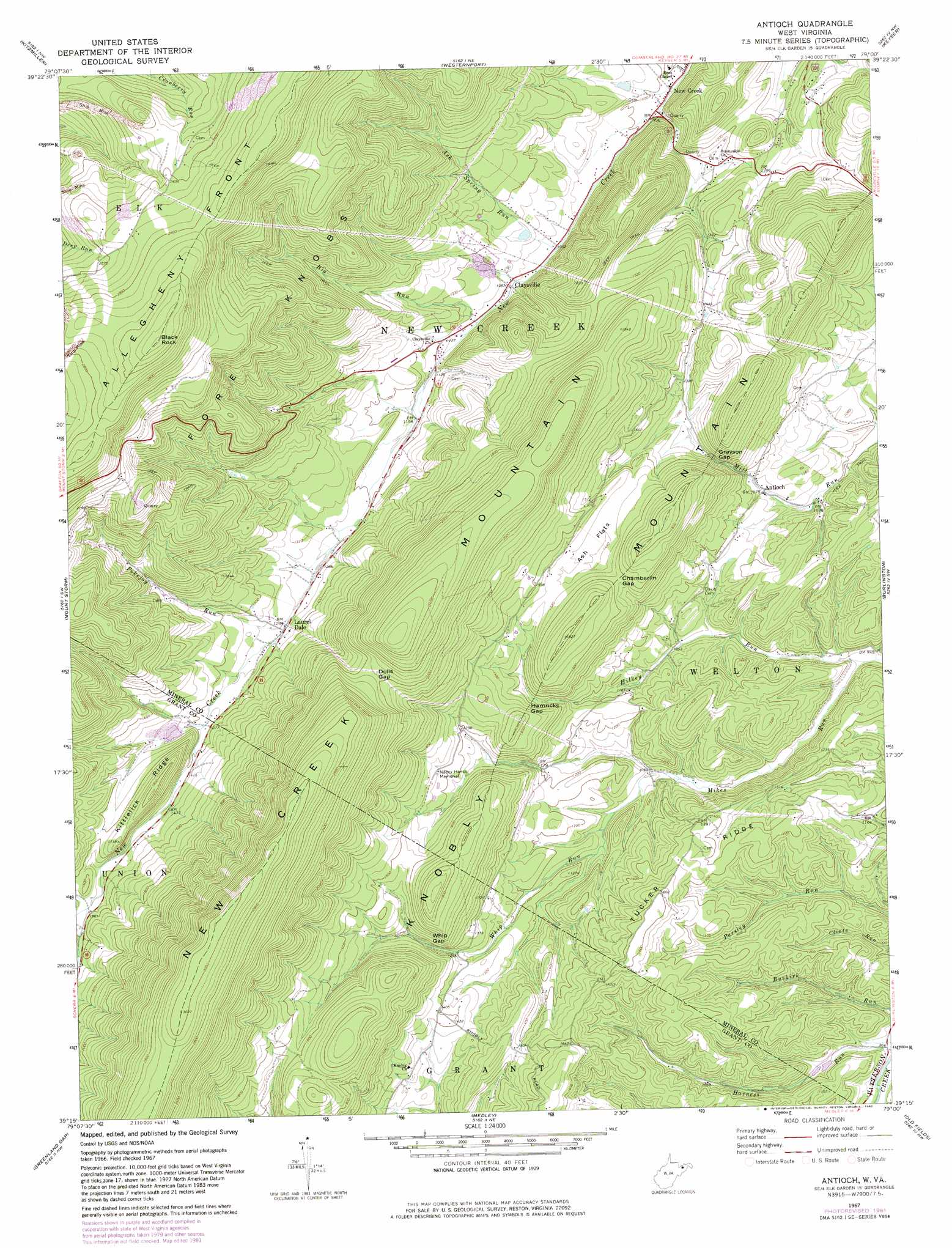
Antioch Topo Map West Virginia
To zoom in, hover over the map of Antioch
USGS Topo Quad 39079c1 - 1:24,000 scale
| Topo Map Name: | Antioch |
| USGS Topo Quad ID: | 39079c1 |
| Print Size: | ca. 21 1/4" wide x 27" high |
| Southeast Coordinates: | 39.25° N latitude / 79° W longitude |
| Map Center Coordinates: | 39.3125° N latitude / 79.0625° W longitude |
| U.S. State: | WV |
| Filename: | o39079c1.jpg |
| Download Map JPG Image: | Antioch topo map 1:24,000 scale |
| Map Type: | Topographic |
| Topo Series: | 7.5´ |
| Map Scale: | 1:24,000 |
| Source of Map Images: | United States Geological Survey (USGS) |
| Alternate Map Versions: |
Antioch WV 1967, updated 1972 Download PDF Buy paper map Antioch WV 1967, updated 1982 Download PDF Buy paper map Antioch WV 2011 Download PDF Buy paper map Antioch WV 2014 Download PDF Buy paper map Antioch WV 2016 Download PDF Buy paper map |
1:24,000 Topo Quads surrounding Antioch
Mchenry |
Bittinger |
Barton |
Lonaconing |
Cresaptown |
Deer Park |
Kitzmiller |
Westernport |
Keyser |
Headsville |
Gorman |
Mount Storm |
Antioch |
Burlington |
Romney |
Mount Storm Lake |
Greenland Gap |
Medley |
Old Fields |
Sector |
Blackbird Knob |
Maysville |
Rig |
Moorefield |
Needmore |
> Back to 39079a1 at 1:100,000 scale
> Back to 39078a1 at 1:250,000 scale
> Back to U.S. Topo Maps home
Antioch topo map: Gazetteer
Antioch: Dams
New Creek Site 10 Dam elevation 357m 1171′New Creek Structure 12 Dam elevation 446m 1463′
New Creek Structure 17 Dam elevation 338m 1108′
New Creek Structure Seven Dam elevation 315m 1033′
Patterson Creek Structure 14 Dam elevation 262m 859′
Antioch: Flats
Ash Flats elevation 444m 1456′Antioch: Gaps
Chamberlin Gap elevation 474m 1555′Dolls Gap elevation 619m 2030′
Grayson Gap elevation 362m 1187′
Hamricks Gap elevation 410m 1345′
Whip Gap elevation 414m 1358′
Antioch: Parks
Nancy Hanks Memorial elevation 445m 1459′Antioch: Populated Places
Antioch elevation 329m 1079′Claysville elevation 331m 1085′
Laurel Dale elevation 393m 1289′
Antioch: Post Offices
New Creek Post Office elevation 296m 971′Antioch: Ranges
Knobly Mountain elevation 551m 1807′Antioch: Ridges
Kittlelick Ridge elevation 560m 1837′Tucker Ridge elevation 464m 1522′
Antioch: Springs
Big Spring elevation 404m 1325′Elk Garden Spring elevation 846m 2775′
Lemons Spring elevation 444m 1456′
Liller Farm Spring elevation 437m 1433′
Mill Run Spring elevation 373m 1223′
Mineral County Spring elevation 766m 2513′
Antioch: Streams
Ash Spring Run elevation 321m 1053′Big Run elevation 337m 1105′
Hilkey Run elevation 278m 912′
Linton Creek elevation 466m 1528′
Pokejoy Run elevation 396m 1299′
Whip Run elevation 315m 1033′
Antioch: Summits
Black Rock elevation 963m 3159′Antioch digital topo map on disk
Buy this Antioch topo map showing relief, roads, GPS coordinates and other geographical features, as a high-resolution digital map file on DVD:
 map DVD")