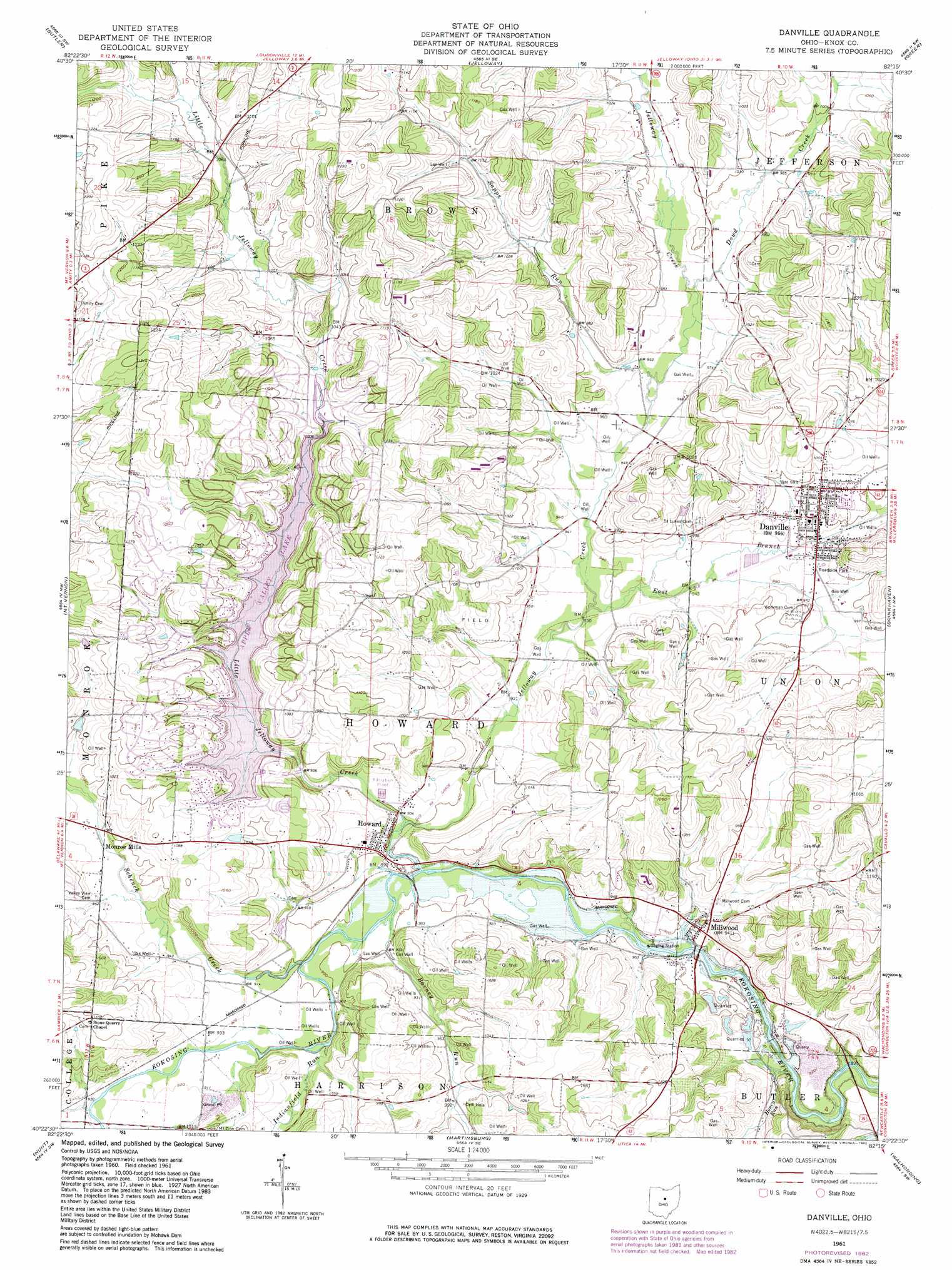
Danville Topo Map Ohio
To zoom in, hover over the map of Danville
USGS Topo Quad 40082d3 - 1:24,000 scale
| Topo Map Name: | Danville |
| USGS Topo Quad ID: | 40082d3 |
| Print Size: | ca. 21 1/4" wide x 27" high |
| Southeast Coordinates: | 40.375° N latitude / 82.25° W longitude |
| Map Center Coordinates: | 40.4375° N latitude / 82.3125° W longitude |
| U.S. State: | OH |
| Filename: | o40082d3.jpg |
| Download Map JPG Image: | Danville topo map 1:24,000 scale |
| Map Type: | Topographic |
| Topo Series: | 7.5´ |
| Map Scale: | 1:24,000 |
| Source of Map Images: | United States Geological Survey (USGS) |
| Alternate Map Versions: |
Danville OH 1961, updated 1963 Download PDF Buy paper map Danville OH 1961, updated 1975 Download PDF Buy paper map Danville OH 1961, updated 1983 Download PDF Buy paper map Danville OH 2010 Download PDF Buy paper map Danville OH 2013 Download PDF Buy paper map Danville OH 2016 Download PDF Buy paper map |
1:24,000 Topo Quads surrounding Danville
Mansfield South |
Lucas |
Perrysville |
Loudonville |
Shreve |
Bellville |
Butler |
Jelloway |
Greer |
Glenmont |
Fredericktown |
Mount Vernon |
Danville |
Brinkhaven |
Spring Mountain |
Homer |
Hunt |
Martinsburg |
Walhonding |
Warsaw |
Fredonia |
Utica |
Hickman |
Perryton |
Trinway |
> Back to 40082a1 at 1:100,000 scale
> Back to 40082a1 at 1:250,000 scale
> Back to U.S. Topo Maps home
Danville topo map: Gazetteer
Danville: Dams
Apple Valley Lake Dam elevation 319m 1046′Danville: Falls
Grove Falls elevation 260m 853′Danville: Populated Places
Buckeye City elevation 297m 974′Danville elevation 303m 994′
Howard elevation 275m 902′
Millwood elevation 284m 931′
Monroe Mills elevation 290m 951′
Pleasant Valley (historical) elevation 331m 1085′
Danville: Post Offices
Buckeye City Post Office (historical) elevation 297m 974′Danville Post Office elevation 304m 997′
Howard Post Office elevation 274m 898′
Millwood Post Office (historical) elevation 286m 938′
Monroe Mills Post Office (historical) elevation 290m 951′
Danville: Reservoirs
Apple Valley Lake elevation 319m 1046′Danville: Streams
Barney Run elevation 271m 889′Dowd Creek elevation 291m 954′
East Branch Jelloway Creek elevation 280m 918′
Honey Run elevation 270m 885′
Indianfield Run elevation 274m 898′
Jelloway Creek elevation 273m 895′
Little Jelloway Creek elevation 274m 898′
Ransoms Run elevation 280m 918′
Sapps Run elevation 286m 938′
Schenck Creek elevation 274m 898′
Shadley Valley Creek elevation 300m 984′
Danville: Valleys
Doudy Valley elevation 295m 967′Danville digital topo map on disk
Buy this Danville topo map showing relief, roads, GPS coordinates and other geographical features, as a high-resolution digital map file on DVD:
 map DVD")