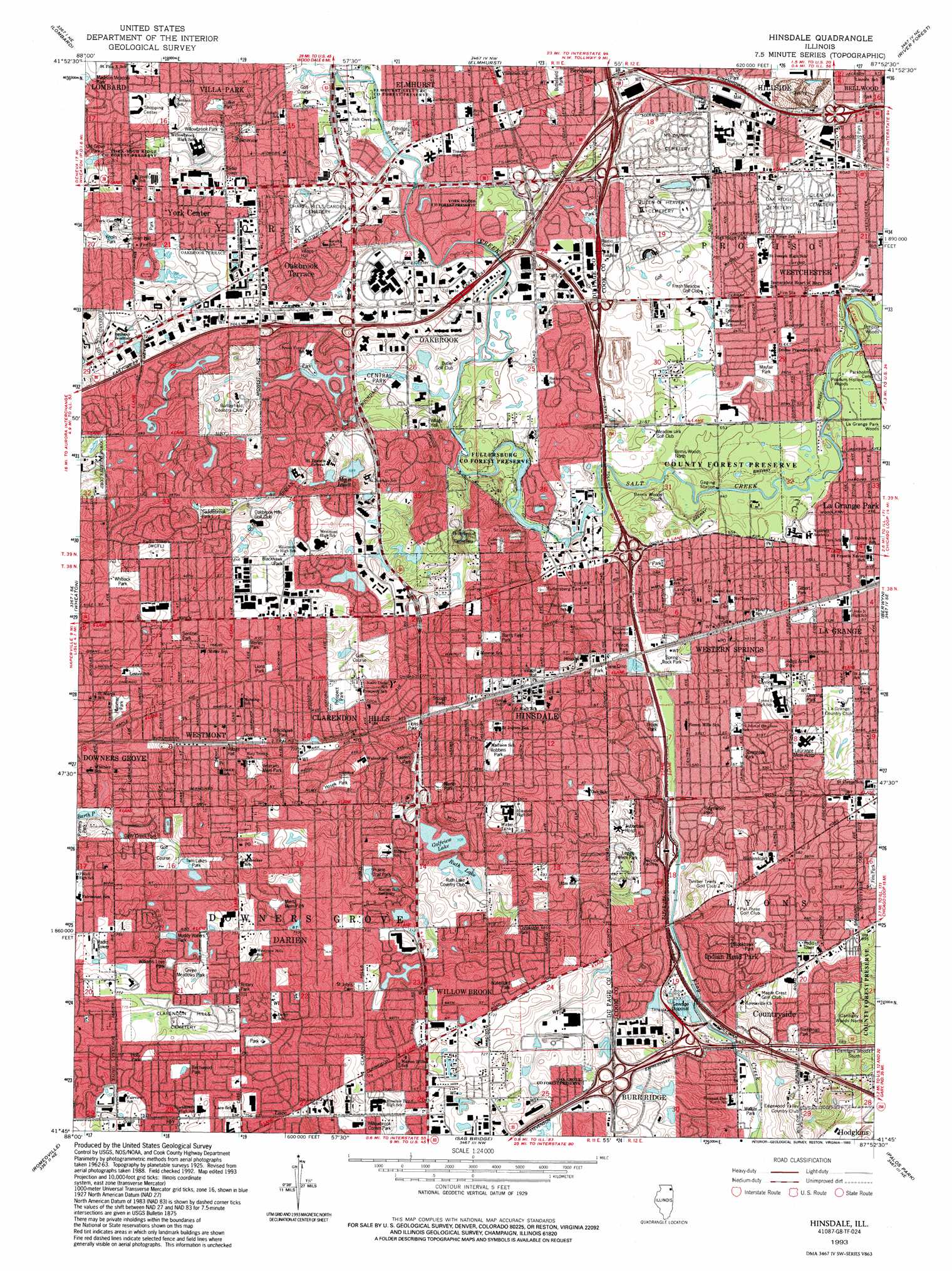
Hinsdale Topo Map Illinois
To zoom in, hover over the map of Hinsdale
USGS Topo Quad 41087g8 - 1:24,000 scale
| Topo Map Name: | Hinsdale |
| USGS Topo Quad ID: | 41087g8 |
| Print Size: | ca. 21 1/4" wide x 27" high |
| Southeast Coordinates: | 41.75° N latitude / 87.875° W longitude |
| Map Center Coordinates: | 41.8125° N latitude / 87.9375° W longitude |
| U.S. State: | IL |
| Filename: | o41087g8.jpg |
| Download Map JPG Image: | Hinsdale topo map 1:24,000 scale |
| Map Type: | Topographic |
| Topo Series: | 7.5´ |
| Map Scale: | 1:24,000 |
| Source of Map Images: | United States Geological Survey (USGS) |
| Alternate Map Versions: |
Hinsdale IL 1927 Download PDF Buy paper map Hinsdale IL 1927 Download PDF Buy paper map Hinsdale IL 1927, updated 1946 Download PDF Buy paper map Hinsdale IL 1953, updated 1956 Download PDF Buy paper map Hinsdale IL 1963, updated 1964 Download PDF Buy paper map Hinsdale IL 1963, updated 1973 Download PDF Buy paper map Hinsdale IL 1963, updated 1981 Download PDF Buy paper map Hinsdale IL 1993, updated 1993 Download PDF Buy paper map Hinsdale IL 1997, updated 1999 Download PDF Buy paper map Hinsdale IL 2012 Download PDF Buy paper map Hinsdale IL 2015 Download PDF Buy paper map |
1:24,000 Topo Quads surrounding Hinsdale
Streamwood |
Palatine |
Arlington Heights |
Park Ridge |
Evanston |
West Chicago |
Lombard |
Elmhurst |
River Forest |
Chicago Loop |
Naperville |
Wheaton |
Hinsdale |
Berwyn |
Englewood |
Normantown |
Romeoville |
Sag Bridge |
Palos Park |
Blue Island |
Plainfield |
Joliet |
Mokena |
Tinley Park |
Harvey |
> Back to 41087e1 at 1:100,000 scale
> Back to 41086a1 at 1:250,000 scale
> Back to U.S. Topo Maps home
Hinsdale topo map: Gazetteer
Hinsdale: Airports
Chicago Bridge and Iron Heliport elevation 203m 666′J W Scott Heliport elevation 208m 682′
La Grange Memorial Hospital Heliport elevation 206m 675′
Madison Avenue Venture Heliport elevation 216m 708′
McDonalds Plaza Heliport elevation 204m 669′
Official Airline Guides Heliport elevation 200m 656′
Waste Management Inc Heliport elevation 218m 715′
Hinsdale: Crossings
Interchange 276 elevation 213m 698′Interchange 277 elevation 207m 679′
Hinsdale: Lakes
Barth Pond elevation 216m 708′Golfview Lake elevation 215m 705′
Johnson Slough elevation 215m 705′
Mays Lakes elevation 213m 698′
Ruth Lake elevation 214m 702′
Hinsdale: Parks
Bellerive Park elevation 226m 741′Birchwood Park elevation 233m 764′
Blackhawk Park elevation 223m 731′
Blackhawk Park elevation 225m 738′
Blackhawk Park elevation 215m 705′
Brook Park elevation 198m 649′
Burns Field Park elevation 219m 718′
Burnside Park elevation 219m 718′
Butterfield Park elevation 213m 698′
Central Park elevation 203m 666′
Cerran Park elevation 191m 626′
Creekside Park elevation 215m 705′
Darien Community Park elevation 224m 734′
Darien Sportsplex elevation 221m 725′
Deer Creek Park elevation 219m 718′
Denning Park elevation 204m 669′
Eastern Park elevation 219m 718′
Eldridge Park elevation 202m 662′
Finn Park elevation 203m 666′
Fritz Werley Park elevation 227m 744′
Fullersberg Park elevation 196m 643′
Fullersburg County Forest Preserve elevation 197m 646′
Gilbert Park elevation 197m 646′
Gladstone Park elevation 192m 629′
Green Meadows Park elevation 228m 748′
Holly Park elevation 233m 764′
Hosek Park elevation 224m 734′
Hummer Park elevation 221m 725′
Kiwanis Park elevation 225m 738′
Knolls Park elevation 218m 715′
Laidlaw Park elevation 204m 669′
Lebeck Park elevation 228m 748′
Legge Memorial Park elevation 200m 656′
Lions Park elevation 221m 725′
Lions Park elevation 228m 748′
Lufkin Park elevation 205m 672′
Mary Egan Park elevation 229m 751′
Mayfair Park elevation 196m 643′
Merlin Park elevation 222m 728′
Mertz Memorial Park elevation 228m 748′
Muddy Waters Park elevation 224m 734′
Oak Grove County Forest Preserve elevation 220m 721′
Oakwood Park elevation 225m 738′
Old Grove Park elevation 211m 692′
Peirce Park elevation 197m 646′
Prairie Trail Park elevation 221m 725′
Prospect Park elevation 223m 731′
Ridge Acres Park elevation 204m 669′
Ridgewood Park elevation 198m 649′
Robbins Park elevation 217m 711′
Rock Springs Park elevation 196m 643′
Rotary Park elevation 229m 751′
Sadlebrook Park elevation 223m 731′
Salt Creek Woods Nature Preserve elevation 198m 649′
Sentinel Park elevation 225m 738′
Soehrman Park elevation 213m 698′
Spring Rock Park elevation 197m 646′
Springdale Park elevation 199m 652′
Stone and Monroe Park elevation 196m 643′
Stough Park elevation 215m 705′
Twin Lakes Park elevation 222m 728′
Ty Warner Park elevation 224m 734′
Veterans Memorial Park elevation 227m 744′
Waiola Park elevation 199m 652′
Walker Park elevation 190m 623′
Waterford Park elevation 221m 725′
Whitlock Park elevation 233m 764′
Williams Love Park elevation 223m 731′
Willowbrook Community Park elevation 222m 728′
Willowbrook Park elevation 212m 695′
Wolf Road Prairie Nature Preserve elevation 196m 643′
York Woods County Forest Preserve elevation 205m 672′
York-High Ridge County Forest Preserve elevation 209m 685′
Hinsdale: Populated Places
Clarendon Hills elevation 222m 728′Countryside elevation 202m 662′
Darien elevation 231m 757′
Fullersburg elevation 202m 662′
Hinsdale elevation 213m 698′
Indian Head Park elevation 199m 652′
Lace elevation 227m 744′
Mammoth Springs elevation 201m 659′
Oak Brook elevation 202m 662′
Oakbrook Terrace elevation 209m 685′
Utopia elevation 215m 705′
Westchester elevation 194m 636′
Western Springs elevation 205m 672′
Westmont elevation 228m 748′
Willowbrook elevation 223m 731′
York Center elevation 220m 721′
Yorkfield elevation 200m 656′
Hinsdale: Post Offices
Clarendon Hills Post Office elevation 222m 728′Westchester Post Office elevation 194m 636′
Western Springs Post Office elevation 205m 672′
Westmont Post Office elevation 232m 761′
Hinsdale: Reservoirs
Lake Hinsdale elevation 219m 718′Hinsdale: Woods
Bemis Woods North elevation 198m 649′Bemis Woods South elevation 196m 643′
Cantigny Woods North elevation 202m 662′
Cantigny Woods South elevation 204m 669′
La Grange Park Woods elevation 195m 639′
Possum Hollow Woods elevation 194m 636′
Hinsdale digital topo map on disk
Buy this Hinsdale topo map showing relief, roads, GPS coordinates and other geographical features, as a high-resolution digital map file on DVD:
Northern Illinois, Northern Indiana & Southwestern Michigan
Buy digital topo maps: Northern Illinois, Northern Indiana & Southwestern Michigan