Pepperell Topo Map Massachusetts
To zoom in, hover over the map of Pepperell
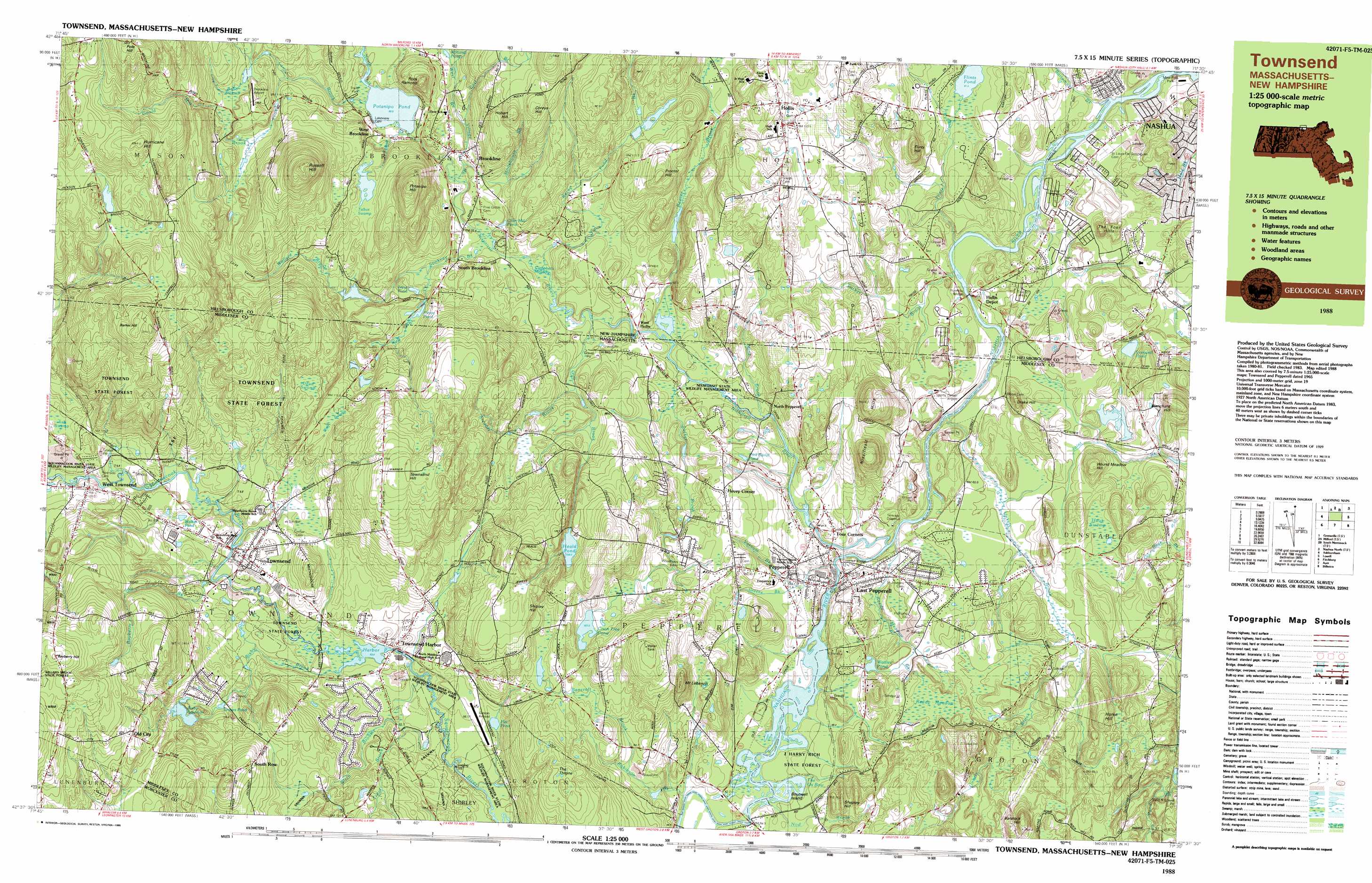
USGS Topo Quad 42071f5 - 1:25,000 scale
| Topo Map Name: | Pepperell |
| USGS Topo Quad ID: | 42071f5 |
| Print Size: | ca. 39" wide x 24" high |
| Southeast Coordinates: | 42.625° N latitude / 71.5° W longitude |
| Map Center Coordinates: | 42.6875° N latitude / 71.625° W longitude |
| U.S. States: | MA, NH |
| Filename: | k42071f5.jpg |
| Download Map JPG Image: | Pepperell topo map 1:25,000 scale |
| Map Type: | Topographic |
| Topo Series: | 7.5´x15´ |
| Map Scale: | 1:25,000 |
| Source of Map Images: | United States Geological Survey (USGS) |
| Alternate Map Versions: |
Townsend MA 1988, updated 1988 Download PDF Buy paper map |
1:24,000 Topo Quads surrounding Pepperell
Greenfield |
New Boston |
Pinardville |
Manchester South |
Derry |
Greenville |
Milford |
South Merrimack |
Nashua North |
Windham |
Ashby |
Pepperell |
Lowell |
||
Fitchburg |
Ayer |
Billerica |
||
Sterling |
Hudson |
Concord |
> Back to 42071e1 at 1:100,000 scale
> Back to 42070a1 at 1:250,000 scale
> Back to U.S. Topo Maps home
Pepperell topo map: Gazetteer
Pepperell: Airports
Brookline Airport elevation 123m 403′Sports Center Airport elevation 53m 173′
The Barn Heliport elevation 72m 236′
Zim Stolport elevation 159m 521′
Pepperell: Basins
Devils Den elevation 78m 255′Pepperell: Bends
The Ox Bow elevation 61m 200′Pepperell: Bridges
Bohannon Bridge elevation 71m 232′Pond Bridge elevation 80m 262′
Runnells Bridge elevation 55m 180′
Pepperell: Dams
Adams Dam elevation 86m 282′Bixby Reservoir Dam elevation 118m 387′
Heald Pond Dam elevation 108m 354′
Mason Road Dam elevation 93m 305′
Mine Falls Dam elevation 52m 170′
Pepperell Paper Company Dam elevation 70m 229′
Potanipo Pond Dam elevation 88m 288′
Rocky Pond Brook Dam elevation 100m 328′
Taylor Pond Dam elevation 112m 367′
Townsend Harbor Dam elevation 85m 278′
Turner Dam elevation 60m 196′
Pepperell: Forests
J Harry Rich State Forest elevation 60m 196′Townsend State Forest elevation 88m 288′
Pepperell: Islands
Boutwell Island elevation 59m 193′Pepperell: Lakes
Cider Mill Pond elevation 73m 239′Dead Pond elevation 131m 429′
Flat Pond elevation 79m 259′
Flints Pond elevation 60m 196′
Graves Pond elevation 105m 344′
Hawk Pond elevation 64m 209′
Lovewell Pond elevation 64m 209′
Pierce Pond elevation 91m 298′
Pork Barrel Pond elevation 77m 252′
Pout Pond elevation 77m 252′
Trout Pond elevation 86m 282′
Walker Pond elevation 95m 311′
Wattles Pond elevation 69m 226′
Williams Pond elevation 86m 282′
Pepperell: Parks
Mine Falls Park elevation 50m 164′Squannacook River State Wildlife Management Area elevation 102m 334′
Pepperell: Populated Places
Babbatasset Village elevation 67m 219′Brookline elevation 87m 285′
Burkinshaws Factory elevation 88m 288′
East Pepperell elevation 70m 229′
Four Corners elevation 64m 209′
Green Acres Trailer Park elevation 68m 223′
Hollis elevation 123m 403′
Hollis Depot elevation 51m 167′
Hovey Corner elevation 97m 318′
North Pepperell elevation 66m 216′
Old City elevation 158m 518′
Paper Mill Village elevation 64m 209′
Pepperell elevation 75m 246′
South Brookline elevation 77m 252′
South Pepperell elevation 81m 265′
South Row elevation 142m 465′
Suburban Village Trailer Park elevation 134m 439′
Townsend elevation 95m 311′
Townsend Harbor elevation 85m 278′
West Brookline elevation 87m 285′
West Hollis elevation 67m 219′
West Townsend elevation 99m 324′
Pepperell: Post Offices
Hollis Post Office elevation 115m 377′Pepperell Post Office elevation 69m 226′
Townsend Post Office elevation 92m 301′
Pepperell: Reservoirs
Beaver Brook Association Pond elevation 100m 328′Bixby Reservoir elevation 118m 387′
Coon Tree Pond elevation 101m 331′
Harbor Pond elevation 85m 278′
Heald Pond elevation 108m 354′
Nashua River Reservoir elevation 70m 229′
Nissitissit River Reservoir elevation 60m 196′
Potanipo Pond elevation 88m 288′
Squannacook River Reservoir elevation 93m 305′
Squannacook River Reservoir elevation 86m 282′
Taylor Pond elevation 112m 367′
Pepperell: Streams
Bancroft Brook elevation 79m 259′Bartemus Brook elevation 48m 157′
Bayberry Hill Brook elevation 87m 285′
Beaver Brook elevation 62m 203′
Bixby Brook elevation 83m 272′
Cow Pond Brook elevation 59m 193′
East Branch Village Brook elevation 75m 246′
Flints Brook elevation 50m 164′
Gould Mill Brook elevation 98m 321′
Gratuity Brook elevation 65m 213′
Greens Brook elevation 71m 232′
Gulf Brook elevation 67m 219′
Gulf Brook elevation 68m 223′
Lancy Brook elevation 81m 265′
Mine Brook elevation 63m 206′
Nissitissit River elevation 53m 173′
Nissitissit River elevation 51m 167′
Nod Brook elevation 59m 193′
North Stream elevation 80m 262′
Nutting Stream elevation 76m 249′
Reedy Meadow Brook elevation 52m 170′
Robinson Brook elevation 61m 200′
Rocky Pond Brook elevation 67m 219′
Stewart Brook elevation 73m 239′
Stickney Brook elevation 70m 229′
Stonehouse Brook elevation 72m 236′
Sucker Brook elevation 64m 209′
Sucker Brook elevation 51m 167′
Talbot Brook elevation 80m 262′
Trout Brook elevation 81m 265′
Unkety Brook elevation 51m 167′
Varnum Brook elevation 51m 167′
Village Brook elevation 70m 229′
Wallace Brook elevation 82m 269′
West Branch Village Brook elevation 75m 246′
Willard Brook elevation 99m 324′
Witch Brook elevation 78m 255′
Wolf Brook elevation 91m 298′
Pepperell: Summits
Baralock Hill elevation 133m 436′Barker Hill elevation 229m 751′
Bayberry Hill elevation 210m 688′
Blanchard Hill elevation 112m 367′
Clarkes Hill elevation 64m 209′
Coreys Hill elevation 156m 511′
Drake Hill elevation 99m 324′
Flints Hill elevation 120m 393′
Hobart Hill elevation 136m 446′
Horse Hill elevation 112m 367′
Hound Meadow Hill elevation 100m 328′
Hurricane Hill elevation 227m 744′
Mount Lebanon elevation 151m 495′
Nissitissit Hills elevation 147m 482′
Oak Hill elevation 138m 452′
Potanipo Hill elevation 185m 606′
Proctor Hill elevation 133m 436′
Rock Ramond elevation 142m 465′
Russell Hill elevation 223m 731′
Shepley Hill elevation 107m 351′
Shipley Hill elevation 142m 465′
The Four Hills elevation 93m 305′
The Throne elevation 135m 442′
Townsend Hill elevation 180m 590′
West Hill elevation 182m 597′
West Hill elevation 183m 600′
Pepperell: Swamps
Babb Swamp elevation 113m 370′Campbells Meadow elevation 68m 223′
Dead Swamp elevation 134m 439′
Hauk Swamp elevation 59m 193′
Reedy Meadow elevation 80m 262′
Talbot Swamp elevation 112m 367′
Wolf Swamp elevation 109m 357′
Pepperell: Valleys
Lost Valley elevation 98m 321′Pepperell digital topo map on disk
Buy this Pepperell topo map showing relief, roads, GPS coordinates and other geographical features, as a high-resolution digital map file on DVD:
Maine, New Hampshire, Rhode Island & Eastern Massachusetts
Buy digital topo maps: Maine, New Hampshire, Rhode Island & Eastern Massachusetts