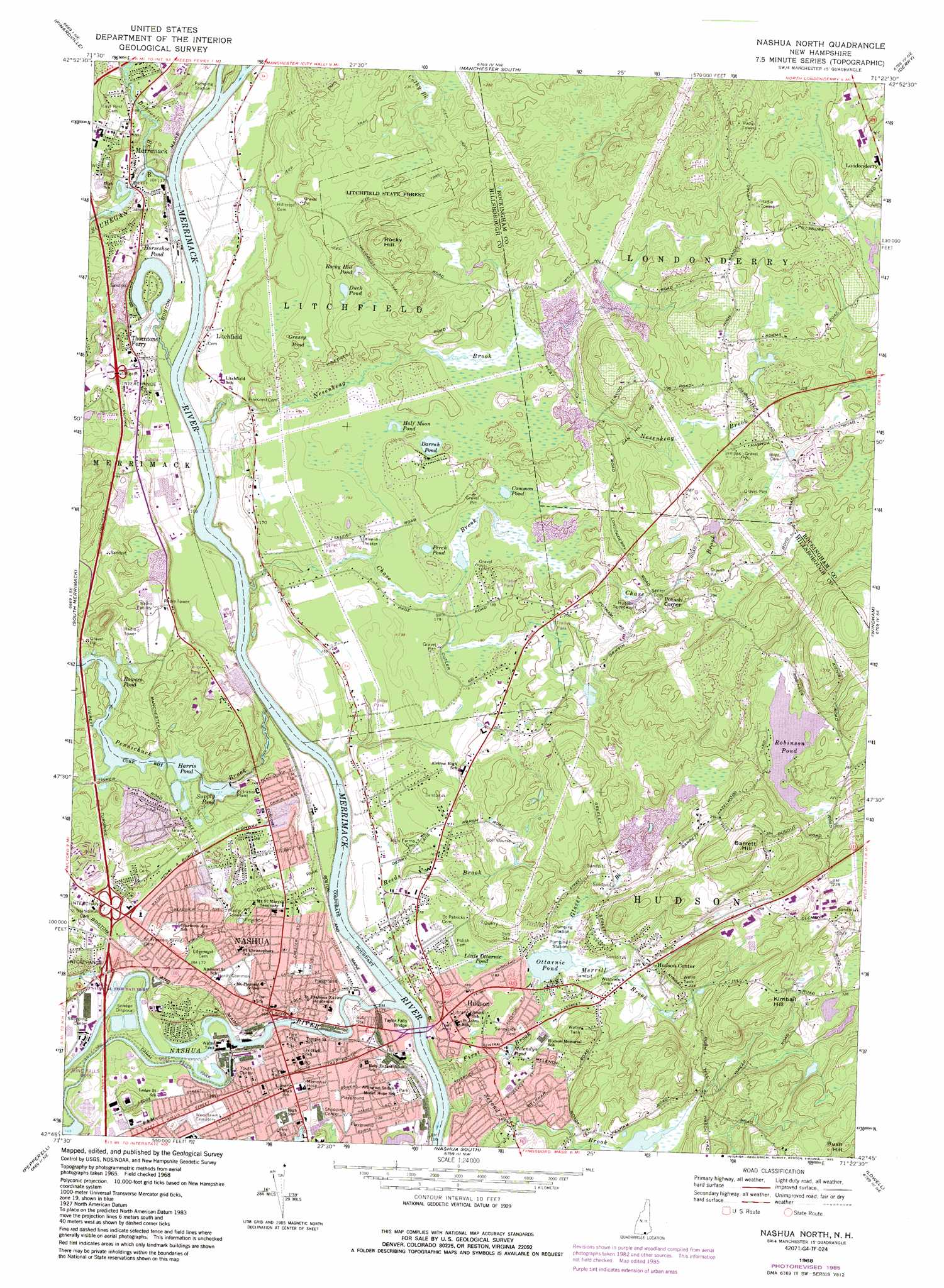
Nashua North Topo Map New Hampshire
To zoom in, hover over the map of Nashua North
USGS Topo Quad 42071g4 - 1:24,000 scale
| Topo Map Name: | Nashua North |
| USGS Topo Quad ID: | 42071g4 |
| Print Size: | ca. 21 1/4" wide x 27" high |
| Southeast Coordinates: | 42.75° N latitude / 71.375° W longitude |
| Map Center Coordinates: | 42.8125° N latitude / 71.4375° W longitude |
| U.S. State: | NH |
| Filename: | o42071g4.jpg |
| Download Map JPG Image: | Nashua North topo map 1:24,000 scale |
| Map Type: | Topographic |
| Topo Series: | 7.5´ |
| Map Scale: | 1:24,000 |
| Source of Map Images: | United States Geological Survey (USGS) |
| Alternate Map Versions: |
Nashua North NH 1968, updated 1971 Download PDF Buy paper map Nashua North NH 1968, updated 1976 Download PDF Buy paper map Nashua North NH 1968, updated 1985 Download PDF Buy paper map Nashua North NH 2012 Download PDF Buy paper map Nashua North NH 2015 Download PDF Buy paper map |
1:24,000 Topo Quads surrounding Nashua North
Weare |
Goffstown |
Manchester North |
Candia |
Mount Pawtuckaway |
New Boston |
Pinardville |
Manchester South |
Derry |
Sandown |
Milford |
South Merrimack |
Nashua North |
Windham |
|
Pepperell |
Lowell |
|||
Ayer |
Billerica |
> Back to 42071e1 at 1:100,000 scale
> Back to 42070a1 at 1:250,000 scale
> Back to U.S. Topo Maps home
Nashua North topo map: Gazetteer
Nashua North: Airports
David Webster Airfield elevation 62m 203′Nashua North: Bridges
Taylor Falls Bridge elevation 32m 104′Nashua North: Capes
Indian Head elevation 39m 127′Nashua North: Crossings
Interchange 6 elevation 42m 137′Interchange 7 elevation 53m 173′
Interchange 8 elevation 58m 190′
Nashua North: Dams
Bowers Dam elevation 53m 173′Harris Pond Dam elevation 49m 160′
Improved Machinery Pond Dam elevation 34m 111′
International Paper Box Company Dam elevation 48m 157′
Jackson Plant Dam elevation 38m 124′
Merrimack Village Dam elevation 36m 118′
Nashua Canal Dike elevation 43m 141′
Supply Pond Dam elevation 39m 127′
Nashua North: Forests
Litchfield State Forest elevation 73m 239′Nashua North: Lakes
Common Pond elevation 56m 183′Darrah Pond elevation 56m 183′
Duck Pond elevation 64m 209′
Half Moon Pond elevation 57m 187′
Horseshoe Pond elevation 29m 95′
Little Ottarnic Pond elevation 50m 164′
Melendys Pond elevation 45m 147′
Ottarnic Pond elevation 50m 164′
Perch Pond elevation 53m 173′
Robinson Pond elevation 65m 213′
Rocky Hill Pond elevation 69m 226′
Nashua North: Parks
Deschenes Oval elevation 45m 147′Greeley Park elevation 45m 147′
Holman Stadium elevation 48m 157′
Kids Kove elevation 43m 141′
Litchfield Town Park elevation 38m 124′
Lyons Field elevation 38m 124′
Nashua Manufacturing Company Historic District elevation 39m 127′
Nashville Historic District elevation 51m 167′
North Common elevation 48m 157′
Russell Memorial Field elevation 45m 147′
Nashua North: Populated Places
East Merrimack elevation 29m 95′Hudson elevation 46m 150′
Hudson Center elevation 58m 190′
Litchfield elevation 37m 121′
Merrimack elevation 47m 154′
Nashua elevation 49m 160′
Potash Corner elevation 66m 216′
Thorntons Ferry elevation 46m 150′
Nashua North: Post Offices
Hudson Post Office elevation 48m 157′Merrimack Post Office elevation 57m 187′
Nashua Post Office elevation 46m 150′
Nashua North: Reservoirs
Bowers Pond elevation 53m 173′Harris Pond elevation 49m 160′
Improved Machinery Pond elevation 34m 111′
Mill Pond elevation 39m 127′
Nashua Canal Reservoir elevation 43m 141′
Salmon Brook Main Street Pond elevation 48m 157′
Souhegan River Reservoir elevation 36m 118′
Supply Pond elevation 39m 127′
Nashua North: Streams
Baboosic Brook elevation 30m 98′Chase Brook elevation 30m 98′
First Brook elevation 29m 95′
Glover Brook elevation 50m 164′
Merrill Brook elevation 50m 164′
Nashua River elevation 29m 95′
Naticook Brook elevation 30m 98′
Nesenkeag Brook elevation 30m 98′
Pennichuck Brook elevation 30m 98′
Reeds Brook elevation 30m 98′
Second Brook elevation 30m 98′
Souhegan River elevation 35m 114′
Nashua North: Summits
Barrett Hill elevation 150m 492′Breakneck Hill elevation 82m 269′
Bush Hill elevation 156m 511′
Kimball Hill elevation 122m 400′
Library Hill elevation 44m 144′
Rocky Hill elevation 105m 344′
Wiley Hill elevation 134m 439′
Nashua North: Swamps
Grassy Pond elevation 57m 187′Nashua North digital topo map on disk
Buy this Nashua North topo map showing relief, roads, GPS coordinates and other geographical features, as a high-resolution digital map file on DVD:
Maine, New Hampshire, Rhode Island & Eastern Massachusetts
Buy digital topo maps: Maine, New Hampshire, Rhode Island & Eastern Massachusetts