South Merrimack Topo Map New Hampshire
To zoom in, hover over the map of South Merrimack
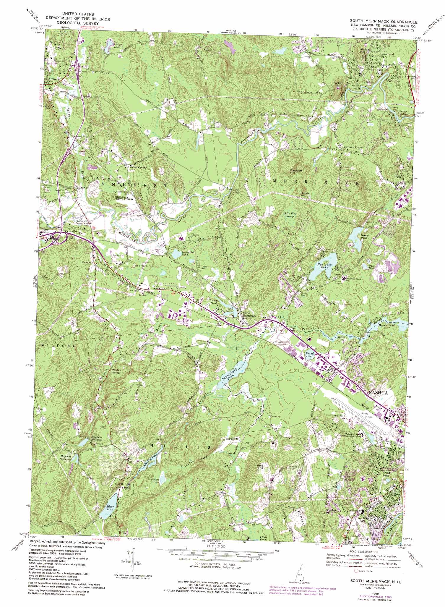
USGS Topo Quad 42071g5 - 1:24,000 scale
| Topo Map Name: | South Merrimack |
| USGS Topo Quad ID: | 42071g5 |
| Print Size: | ca. 21 1/4" wide x 27" high |
| Southeast Coordinates: | 42.75° N latitude / 71.5° W longitude |
| Map Center Coordinates: | 42.8125° N latitude / 71.5625° W longitude |
| U.S. State: | NH |
| Filename: | o42071g5.jpg |
| Download Map JPG Image: | South Merrimack topo map 1:24,000 scale |
| Map Type: | Topographic |
| Topo Series: | 7.5´ |
| Map Scale: | 1:24,000 |
| Source of Map Images: | United States Geological Survey (USGS) |
| Alternate Map Versions: |
South Merrimack NH 1968, updated 1971 Download PDF Buy paper map South Merrimack NH 1968, updated 1977 Download PDF Buy paper map South Merrimack NH 1968, updated 1985 Download PDF Buy paper map South Merrimack NH 1968, updated 1985 Download PDF Buy paper map South Merrimack NH 2012 Download PDF Buy paper map South Merrimack NH 2015 Download PDF Buy paper map |
1:24,000 Topo Quads surrounding South Merrimack
Deering |
Weare |
Goffstown |
Manchester North |
Candia |
Greenfield |
New Boston |
Pinardville |
Manchester South |
Derry |
Greenville |
Milford |
South Merrimack |
Nashua North |
Windham |
Ashby |
Pepperell |
Lowell |
||
Fitchburg |
Ayer |
Billerica |
> Back to 42071e1 at 1:100,000 scale
> Back to 42070a1 at 1:250,000 scale
> Back to U.S. Topo Maps home
South Merrimack topo map: Gazetteer
South Merrimack: Airports
Boire Field elevation 59m 193′Merrimack Heliport elevation 63m 206′
Norden Systems Heliport elevation 63m 206′
South Merrimack: Bridges
Fields Bridge elevation 62m 203′South Merrimack: Crossings
Interchange 1 elevation 89m 291′Interchange 7 elevation 83m 272′
South Merrimack: Dams
Dunklee Pond Dam elevation 82m 269′Farley Brook Dam elevation 60m 196′
Haydens Mill Pond Dam elevation 103m 337′
Holt Dam elevation 54m 177′
Naticook Lake Dam elevation 64m 209′
South Merrimack: Falls
Wildcat Falls elevation 44m 144′South Merrimack: Forests
Hodgman State Forest elevation 76m 249′South Merrimack: Lakes
Beaver Ponds elevation 76m 249′Dream Lake elevation 79m 259′
Duck Pond elevation 63m 206′
Greens Pond elevation 57m 187′
Honey Pot Pond elevation 67m 219′
Little Honey Pot Pond elevation 66m 216′
Parker Pond elevation 82m 269′
Pennichuck Pond elevation 57m 187′
Round Pond elevation 61m 200′
Silver Lake elevation 83m 272′
South Merrimack: Parks
Ponemah Bog Wildlife Refuge elevation 94m 308′Silver Lake State Park elevation 82m 269′
Veterans Memorial Park elevation 63m 206′
Wasseman Park elevation 78m 255′
South Merrimack: Populated Places
Blood (historical) elevation 61m 200′Broad Acres elevation 52m 170′
Cricket Corner elevation 71m 232′
Lawrence Corner elevation 69m 226′
Lincoln Park elevation 50m 164′
Ponemah elevation 71m 232′
South Merrimack elevation 66m 216′
Woodland Park elevation 68m 223′
South Merrimack: Reservoirs
Dunklee Pond elevation 82m 269′Haydens Millpond elevation 92m 301′
Haydens Reservoir elevation 103m 337′
Holts Pond elevation 54m 177′
Naticook Lake elevation 64m 209′
Stump Pond elevation 58m 190′
Worcesters Millpond elevation 121m 396′
South Merrimack: Springs
Witches Spring elevation 68m 223′South Merrimack: Streams
Beaver Brook elevation 65m 213′Muddy Brook elevation 58m 190′
Parker Pond Brook elevation 61m 200′
Witches Brook elevation 58m 190′
South Merrimack: Summits
Blodgett Hill elevation 123m 403′Horse Hill elevation 116m 380′
Middle Hill elevation 100m 328′
Pine Hill elevation 133m 436′
Shipley Hill elevation 117m 383′
Turkey Hill elevation 109m 357′
South Merrimack: Swamps
White Pine Swamp elevation 94m 308′South Merrimack: Woods
Ponemah Forest elevation 67m 219′South Merrimack digital topo map on disk
Buy this South Merrimack topo map showing relief, roads, GPS coordinates and other geographical features, as a high-resolution digital map file on DVD:
Maine, New Hampshire, Rhode Island & Eastern Massachusetts
Buy digital topo maps: Maine, New Hampshire, Rhode Island & Eastern Massachusetts