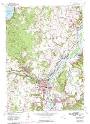
Mechanicville Topo Map New York
To zoom in, hover over the map of Mechanicville
USGS Topo Quad 42073h6 - 1:24,000 scale
| Topo Map Name: | Mechanicville |
| USGS Topo Quad ID: | 42073h6 |
| Print Size: | ca. 21 1/4" wide x 27" high |
| Southeast Coordinates: | 42.875° N latitude / 73.625° W longitude |
| Map Center Coordinates: | 42.9375° N latitude / 73.6875° W longitude |
| U.S. State: | NY |
| Filename: | o42073h6.jpg |
| Download Map JPG Image: | Mechanicville topo map 1:24,000 scale |
| Map Type: | Topographic |
| Topo Series: | 7.5´ |
| Map Scale: | 1:24,000 |
| Source of Map Images: | United States Geological Survey (USGS) |
| Alternate Map Versions: |
Mechanicville NY 1954, updated 1956 Download PDF Buy paper map Mechanicville NY 1954, updated 1967 Download PDF Buy paper map Mechanicville NY 1954, updated 1980 Download PDF Buy paper map Mechanicville NY 1954, updated 1988 Download PDF Buy paper map Mechanicville NY 2010 Download PDF Buy paper map Mechanicville NY 2013 Download PDF Buy paper map Mechanicville NY 2016 Download PDF Buy paper map |
1:24,000 Topo Quads surrounding Mechanicville
> Back to 42073e1 at 1:100,000 scale
> Back to 42072a1 at 1:250,000 scale
> Back to U.S. Topo Maps home
Mechanicville topo map: Gazetteer
Mechanicville: Airports
Burrello-Mechanicville Airport elevation 58m 190′Mechanicville: Areas
Pachgatgoch elevation 20m 65′Mechanicville: Dams
Lock Number 2 elevation 8m 26′Lock Number 3 elevation 22m 72′
Lock Number 4 elevation 25m 82′
Mechanicville: Islands
Green Island elevation 32m 104′Quack Island elevation 21m 68′
Mechanicville: Lakes
Black Pond elevation 102m 334′Mechanicville: Parks
Blockhouse Park elevation 20m 65′Saratoga National Historical Park elevation 76m 249′
Talmadge Park elevation 35m 114′
Village Cannon Park elevation 26m 85′
Mechanicville: Populated Places
Bemis Heights elevation 31m 101′Canfield Trailer Park elevation 89m 291′
Coons elevation 52m 170′
East Saratoga Junciton elevation 39m 127′
Hallum Trailer Park elevation 33m 108′
Hemstreet Park elevation 21m 68′
Hillside Colony elevation 98m 321′
John S Moore Homes elevation 30m 98′
Mechanicville elevation 27m 88′
Reynolds elevation 61m 200′
Riverside elevation 25m 82′
Riviera Estates elevation 28m 91′
Stillwater elevation 28m 91′
Stillwater Center elevation 124m 406′
Stillwater Junction elevation 38m 124′
Thompson Trailer Park elevation 30m 98′
Willow Glen elevation 36m 118′
Mechanicville: Reservoirs
Mechanicville Reservoir elevation 75m 246′Mechanicville: Ridges
Bemis Heights elevation 98m 321′Mechanicville: Streams
Anthony Kill elevation 16m 52′Hoosic River elevation 20m 65′
Mill Hollow Brook elevation 25m 82′
Plum Brook elevation 32m 104′
Schuyler Creek elevation 22m 72′
Tomhannock Creek elevation 31m 101′
Mechanicville: Summits
Cornell Hill elevation 131m 429′Mechanicville: Valleys
Middle Ravine elevation 58m 190′Mechanicville digital topo map on disk
Buy this Mechanicville topo map showing relief, roads, GPS coordinates and other geographical features, as a high-resolution digital map file on DVD:
New York, Vermont, Connecticut & Western Massachusetts
Buy digital topo maps: New York, Vermont, Connecticut & Western Massachusetts


