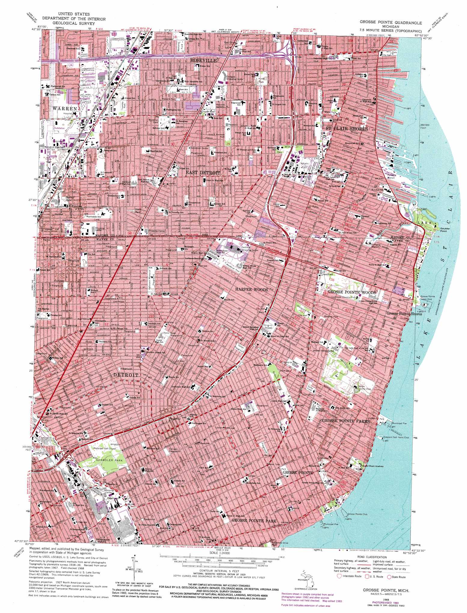
Grosse Pointe Topo Map Michigan
To zoom in, hover over the map of Grosse Pointe
USGS Topo Quad 42082d8 - 1:24,000 scale
| Topo Map Name: | Grosse Pointe |
| USGS Topo Quad ID: | 42082d8 |
| Print Size: | ca. 21 1/4" wide x 27" high |
| Southeast Coordinates: | 42.375° N latitude / 82.875° W longitude |
| Map Center Coordinates: | 42.4375° N latitude / 82.9375° W longitude |
| U.S. State: | MI |
| Filename: | o42082d8.jpg |
| Download Map JPG Image: | Grosse Pointe topo map 1:24,000 scale |
| Map Type: | Topographic |
| Topo Series: | 7.5´ |
| Map Scale: | 1:24,000 |
| Source of Map Images: | United States Geological Survey (USGS) |
| Alternate Map Versions: |
Grosse Pointe MI 1940 Download PDF Buy paper map Grosse Pointe MI 1952, updated 1953 Download PDF Buy paper map Grosse Pointe MI 1968, updated 1971 Download PDF Buy paper map Grosse Pointe MI 1968, updated 1974 Download PDF Buy paper map Grosse Pointe MI 1968, updated 1984 Download PDF Buy paper map Grosse Pointe MI 1968, updated 1984 Download PDF Buy paper map Grosse Pointe MI 2011 Download PDF Buy paper map Grosse Pointe MI 2014 Download PDF Buy paper map Grosse Pointe MI 2017 Download PDF Buy paper map |
1:24,000 Topo Quads surrounding Grosse Pointe
Rochester |
Utica |
Waldenburg |
New Haven |
New Baltimore |
Birmingham |
Warren |
Mount Clemens West |
Mount Clemens East |
Saint Clair Flats |
Royal Oak |
Highland Park |
Grosse Pointe |
||
Dearborn |
Detroit |
Belle Isle |
||
Wyandotte |
> Back to 42082a1 at 1:100,000 scale
> Back to 42082a1 at 1:250,000 scale
> Back to U.S. Topo Maps home
Grosse Pointe topo map: Gazetteer
Grosse Pointe: Parks
Balduck Memorial Park elevation 178m 583′Chandler Park elevation 184m 603′
Conner Playground elevation 186m 610′
Corrigan Playground elevation 182m 597′
Ghesquiere Park elevation 178m 583′
Goetz Park elevation 187m 613′
Heilmann Memorial Playground elevation 185m 606′
Huron Park elevation 183m 600′
John F Kennedy Park elevation 184m 603′
Kerby Field elevation 177m 580′
Lakefront Park elevation 177m 580′
Macomb Gardens elevation 186m 610′
Packard Park elevation 189m 620′
Saint Clair Shores Park elevation 175m 574′
Sasser Playground elevation 180m 590′
Sweeney Park elevation 178m 583′
Trombly Park elevation 189m 620′
Winters Park elevation 190m 623′
Grosse Pointe: Populated Places
Conners Creek elevation 189m 620′Eastpointe elevation 187m 613′
Grosse Pointe elevation 179m 587′
Grosse Pointe Farms elevation 186m 610′
Grosse Pointe Park elevation 177m 580′
Grosse Pointe Shores elevation 177m 580′
Grosse Pointe Woods elevation 178m 583′
Harper Woods elevation 179m 587′
Roseville elevation 187m 613′
Saint Clair Shores elevation 177m 580′
Grosse Pointe: Post Offices
Eastpointe Post Office elevation 187m 613′Grosse Pointe: Streams
Milk River elevation 175m 574′Grosse Pointe digital topo map on disk
Buy this Grosse Pointe topo map showing relief, roads, GPS coordinates and other geographical features, as a high-resolution digital map file on DVD:
 map DVD")