Waldenburg Topo Map Michigan
To zoom in, hover over the map of Waldenburg
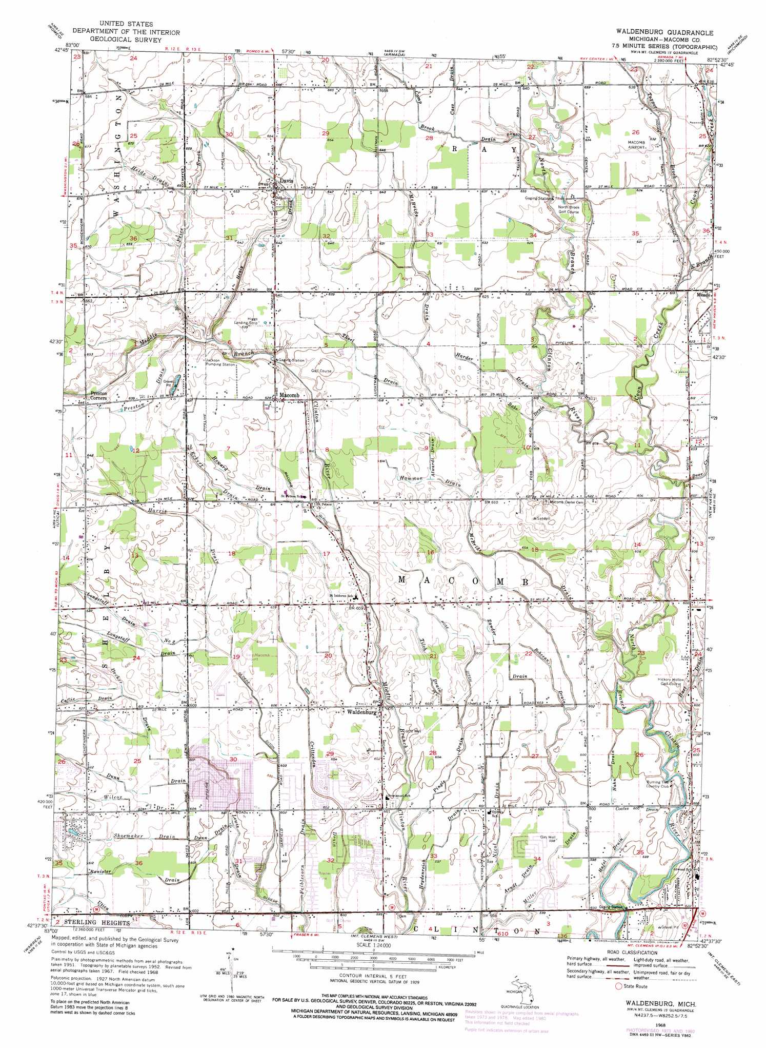
USGS Topo Quad 42082f8 - 1:24,000 scale
| Topo Map Name: | Waldenburg |
| USGS Topo Quad ID: | 42082f8 |
| Print Size: | ca. 21 1/4" wide x 27" high |
| Southeast Coordinates: | 42.625° N latitude / 82.875° W longitude |
| Map Center Coordinates: | 42.6875° N latitude / 82.9375° W longitude |
| U.S. State: | MI |
| Filename: | o42082f8.jpg |
| Download Map JPG Image: | Waldenburg topo map 1:24,000 scale |
| Map Type: | Topographic |
| Topo Series: | 7.5´ |
| Map Scale: | 1:24,000 |
| Source of Map Images: | United States Geological Survey (USGS) |
| Alternate Map Versions: |
Waldenburg MI 1952, updated 1954 Download PDF Buy paper map Waldenburg MI 1968, updated 1970 Download PDF Buy paper map Waldenburg MI 1968, updated 1974 Download PDF Buy paper map Waldenburg MI 1968, updated 1981 Download PDF Buy paper map Waldenburg MI 2011 Download PDF Buy paper map Waldenburg MI 2014 Download PDF Buy paper map Waldenburg MI 2017 Download PDF Buy paper map |
1:24,000 Topo Quads surrounding Waldenburg
Thornville |
Almont |
Allenton |
Memphis |
Goodells |
Lake Orion |
Romeo |
Armada |
Richmond |
Adair |
Rochester |
Utica |
Waldenburg |
New Haven |
New Baltimore |
Birmingham |
Warren |
Mount Clemens West |
Mount Clemens East |
Saint Clair Flats |
Royal Oak |
Highland Park |
Grosse Pointe |
> Back to 42082e1 at 1:100,000 scale
> Back to 42082a1 at 1:250,000 scale
> Back to U.S. Topo Maps home
Waldenburg topo map: Gazetteer
Waldenburg: Airports
Berz-Macomb Airport elevation 186m 610′Jott Heliport elevation 191m 626′
Macomb Airport elevation 192m 629′
Waldenburg: Canals
Gloede Ditch elevation 181m 593′Lewis Ditch elevation 185m 606′
Macomb Ditch elevation 186m 610′
Rose Ditch elevation 184m 603′
Waldenburg: Populated Places
Davis elevation 198m 649′Macomb elevation 191m 626′
Preston Corners elevation 197m 646′
Waldenburg elevation 184m 603′
Waldenburg: Streams
Alwardt Drain elevation 186m 610′Arndt Drain elevation 181m 593′
Banister Drain elevation 181m 593′
Bobcean Drain elevation 183m 600′
Caflic Drain elevation 187m 613′
Camp Brook Drain elevation 189m 620′
Cass Drain elevation 194m 636′
Coates Drain elevation 180m 590′
Conklin Drain elevation 179m 587′
Coon Creek elevation 182m 597′
Decker Drain elevation 184m 603′
Deer Creek elevation 182m 597′
Dunn Drain elevation 181m 593′
East Branch Coon Creek elevation 186m 610′
Eckert Drain elevation 185m 606′
Feiblecorn Drain elevation 180m 590′
Hafel Drain elevation 178m 583′
Hahn Drain elevation 182m 597′
Hammon Drain elevation 185m 606′
Harder Drain elevation 186m 610′
Harris Drain elevation 184m 603′
Hart Drain elevation 178m 583′
Healy Drain elevation 189m 620′
Heide Drain elevation 196m 643′
Heydenreich Drain elevation 179m 587′
Howard Drain elevation 186m 610′
Lewis Drain elevation 180m 590′
Longstaff Drain elevation 184m 603′
Longstaff Drain Number Two elevation 184m 603′
McBride Drain elevation 180m 590′
Nicol Drain elevation 180m 590′
Pingle Drain elevation 179m 587′
Preston Drain elevation 190m 623′
Price Brook elevation 189m 620′
Rabe Drain elevation 184m 603′
Shoemaker Drain elevation 183m 600′
Steinbrink Drain elevation 180m 590′
Thoel Drain elevation 186m 610′
Tilch Drain elevation 182m 597′
Tupper Brook elevation 186m 610′
Wilcox Drain elevation 183m 600′
Zander Drain elevation 183m 600′
Waldenburg digital topo map on disk
Buy this Waldenburg topo map showing relief, roads, GPS coordinates and other geographical features, as a high-resolution digital map file on DVD:
 map DVD")