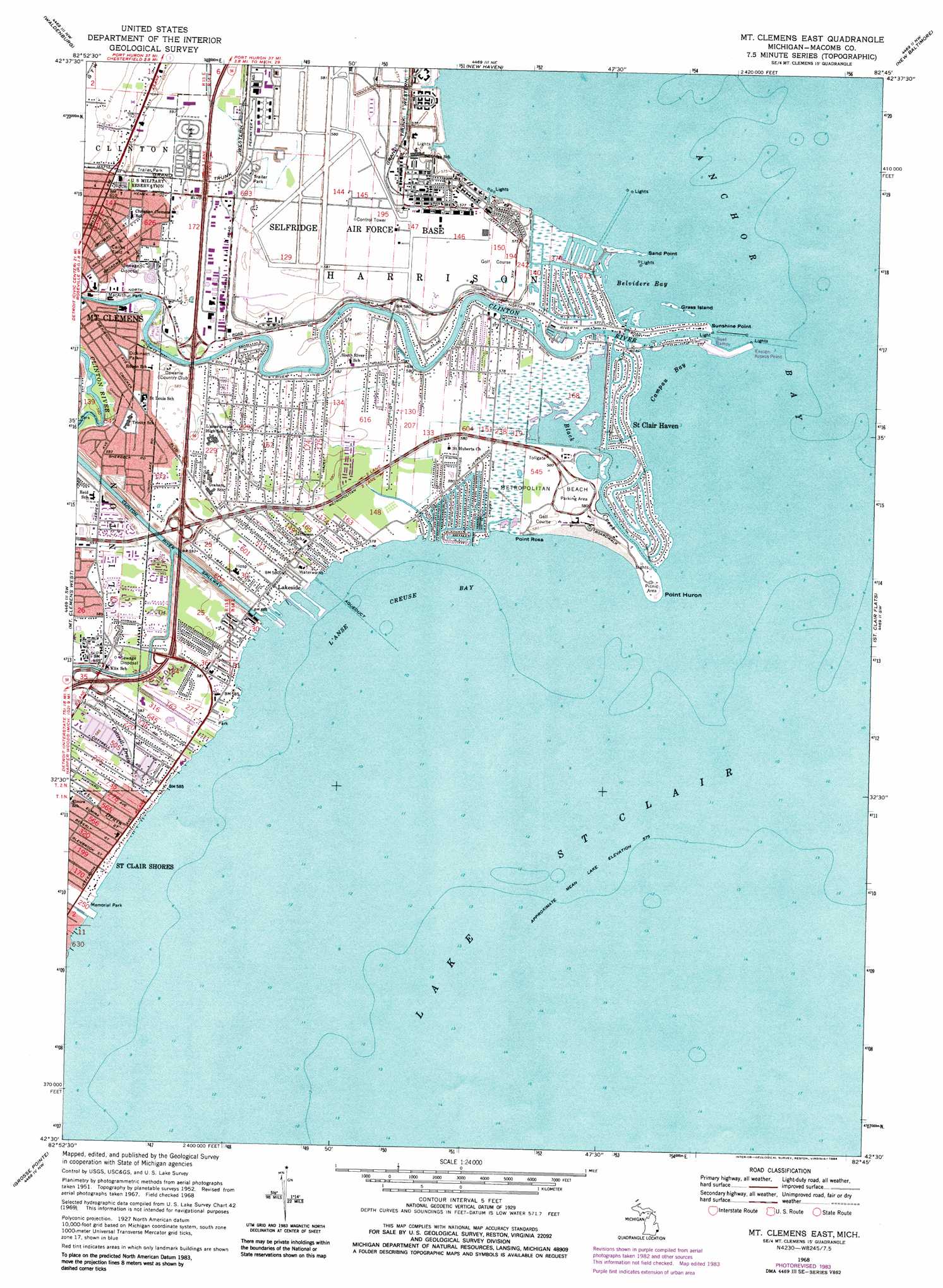
Mount Clemens East Topo Map Michigan
To zoom in, hover over the map of Mount Clemens East
USGS Topo Quad 42082e7 - 1:24,000 scale
| Topo Map Name: | Mount Clemens East |
| USGS Topo Quad ID: | 42082e7 |
| Print Size: | ca. 21 1/4" wide x 27" high |
| Southeast Coordinates: | 42.5° N latitude / 82.75° W longitude |
| Map Center Coordinates: | 42.5625° N latitude / 82.8125° W longitude |
| U.S. State: | MI |
| Filename: | o42082e7.jpg |
| Download Map JPG Image: | Mount Clemens East topo map 1:24,000 scale |
| Map Type: | Topographic |
| Topo Series: | 7.5´ |
| Map Scale: | 1:24,000 |
| Source of Map Images: | United States Geological Survey (USGS) |
| Alternate Map Versions: |
Mt Clemens East MI 1952, updated 1954 Download PDF Buy paper map Mt Clemens East MI 1968, updated 1971 Download PDF Buy paper map Mt Clemens East MI 1968, updated 1974 Download PDF Buy paper map Mt Clemens East MI 1968, updated 1984 Download PDF Buy paper map Mount Clemens East MI 2011 Download PDF Buy paper map Mount Clemens East MI 2014 Download PDF Buy paper map Mount Clemens East MI 2017 Download PDF Buy paper map |
1:24,000 Topo Quads surrounding Mount Clemens East
Romeo |
Armada |
Richmond |
Adair |
Rattle Run |
Utica |
Waldenburg |
New Haven |
New Baltimore |
Marine City |
Warren |
Mount Clemens West |
Mount Clemens East |
Saint Clair Flats |
Algonac |
Highland Park |
Grosse Pointe |
|||
Detroit |
Belle Isle |
> Back to 42082e1 at 1:100,000 scale
> Back to 42082a1 at 1:250,000 scale
> Back to U.S. Topo Maps home
Mount Clemens East topo map: Gazetteer
Mount Clemens East: Airports
Selfridge ANGB Airport elevation 177m 580′Mount Clemens East: Bays
Belvidere Bay elevation 175m 574′Campau Bay elevation 175m 574′
L'anse Creuse Bay elevation 175m 574′
Mount Clemens East: Canals
Clinton River Spillway elevation 175m 574′Mount Clemens East: Capes
Point Huron elevation 176m 577′Point Rosa elevation 177m 580′
Sand Point elevation 175m 574′
Sunshine Point elevation 176m 577′
Mount Clemens East: Islands
Grass Island elevation 176m 577′Mount Clemens East: Parks
Cairns Field elevation 181m 593′Dickinson Park elevation 179m 587′
MacArthur Park elevation 178m 583′
Metropolitan Beach elevation 177m 580′
Mount Clemens East: Populated Places
Lakeside elevation 177m 580′Saint Clair Haven elevation 176m 577′
Mount Clemens East: Streams
Black Creek elevation 175m 574′Clinton River elevation 175m 574′
Cottrell Drain elevation 178m 583′
Peltier Drain elevation 178m 583′
Tebo Drain elevation 177m 580′
Mount Clemens East digital topo map on disk
Buy this Mount Clemens East topo map showing relief, roads, GPS coordinates and other geographical features, as a high-resolution digital map file on DVD:
 map DVD")