Busseyville Topo Map Wisconsin
To zoom in, hover over the map of Busseyville
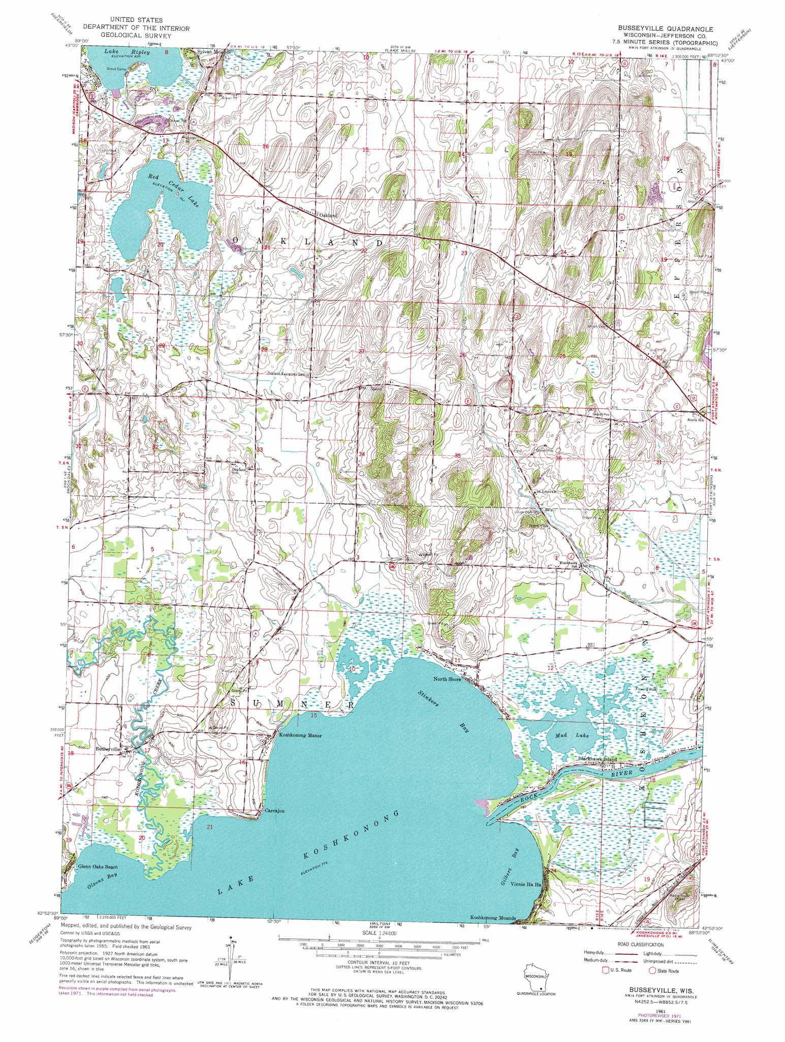
USGS Topo Quad 42088h8 - 1:24,000 scale
| Topo Map Name: | Busseyville |
| USGS Topo Quad ID: | 42088h8 |
| Print Size: | ca. 21 1/4" wide x 27" high |
| Southeast Coordinates: | 42.875° N latitude / 88.875° W longitude |
| Map Center Coordinates: | 42.9375° N latitude / 88.9375° W longitude |
| U.S. State: | WI |
| Filename: | o42088h8.jpg |
| Download Map JPG Image: | Busseyville topo map 1:24,000 scale |
| Map Type: | Topographic |
| Topo Series: | 7.5´ |
| Map Scale: | 1:24,000 |
| Source of Map Images: | United States Geological Survey (USGS) |
| Alternate Map Versions: |
Busseyville WI 1961, updated 1964 Download PDF Buy paper map Busseyville WI 1961, updated 1972 Download PDF Buy paper map Busseyville WI 2010 Download PDF Buy paper map Busseyville WI 2013 Download PDF Buy paper map Busseyville WI 2016 Download PDF Buy paper map |
1:24,000 Topo Quads surrounding Busseyville
Sun Prairie |
Marshall |
Waterloo |
Richwood |
Watertown |
Cottage Grove |
Deerfield |
Lake Mills |
Jefferson |
Helenville |
Stoughton |
Rockdale |
Busseyville |
Fort Atkinson |
Rome |
Cooksville |
Edgerton |
Milton |
Lima Center |
Whitewater |
Footville |
Janesville West |
Janesville East |
Avalon |
Delavan |
> Back to 42088e1 at 1:100,000 scale
> Back to 42088a1 at 1:250,000 scale
> Back to U.S. Topo Maps home
Busseyville topo map: Gazetteer
Busseyville: Airports
Christie Aerodrome elevation 245m 803′Busseyville: Bays
Gilbert Bay elevation 236m 774′Olsons Bay elevation 236m 774′
Stinkers Bay elevation 236m 774′
Busseyville: Lakes
Mud Lake elevation 237m 777′Red Cedar Lake elevation 257m 843′
Busseyville: Parks
Red Cedar Lake State Natural Area elevation 259m 849′Busseyville: Populated Places
Blackhawk Island elevation 238m 780′Busseyville elevation 241m 790′
Carcajou elevation 245m 803′
Glenn Oaks Beach elevation 244m 800′
Koshkonong Manor elevation 247m 810′
Lake Koshkonong elevation 238m 780′
North Shore elevation 240m 787′
Oakland elevation 268m 879′
Sylvan Mounds elevation 262m 859′
Vinnie Ha Ha elevation 250m 820′
Busseyville: Streams
Koshkonong Creek elevation 236m 774′Busseyville digital topo map on disk
Buy this Busseyville topo map showing relief, roads, GPS coordinates and other geographical features, as a high-resolution digital map file on DVD:
Northern Illinois, Northern Indiana & Southwestern Michigan
Buy digital topo maps: Northern Illinois, Northern Indiana & Southwestern Michigan